Mangaia facts for kids
|
Native name:
A'ua'u
|
|
|---|---|

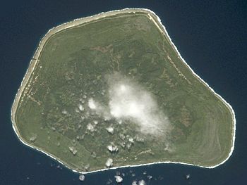
NASA picture of Mangaia Island
|
|

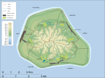
Map of Mangaia Island
|
|
| Geography | |
| Location | Central-Southern Pacific Ocean |
| Coordinates | 21°55′S 157°57′W / 21.917°S 157.950°W |
| Archipelago | Cook Islands |
| Area | 51.8 km2 (20.0 sq mi) |
| Administration | |
| Villages |
|
| Demographics | |
| Demonym | Mangaian |
| Population | 499 (2016) |
Mangaia (also known as A'ua'u Enua, meaning terraced) is the most southern island in the Cook Islands. It is the second largest island there, after Rarotonga. Mangaia is a round-shaped island, covering about 51.8 square kilometers (20 square miles). It is about 203 kilometers (126 miles) away from Rarotonga. Long ago, many people lived on Mangaia. However, its population has dropped by 75% in the last 50 years.
Contents
History
People first settled on Mangaia around the year 1000 CE. This was found by digging at a place called the Tangatatau Rockshelter. Old stories say the island didn't just get discovered. Instead, it rose from an underworld called Avaiki with people already living on it. Later, more people came to Mangaia from other islands like Rarotonga, Aitutaki, Atiu, Tonga, and Tahiti.
Tools made of stone found on the island show that people traded with Rarotonga, Samoa, and Raiatea. At first, people lived in villages along the coast. But by the 1500s, they moved further inland. Trading between islands almost stopped. Stories from this time tell of chiefs fighting for land and power.
Europeans first found Mangaia on March 29, 1777. This was when Captain James Cook arrived. A few more ships visited, possibly including the HMS Bounty. Then, John Williams, a missionary, arrived in 1823. He couldn't land at first. But in 1824, he came back and left two preachers from Taha'a. These preachers started to teach the islanders about Christianity.
Before the missionaries came, Mangaian society was often violent. War leaders fought to become the mangaia, which meant having the most power. The Ariki were like priests, not chiefs who inherited their power. The last mangaia, Pangemiro, died soon after the missionaries arrived. When war was stopped because of Christianity, the power structure stayed the same as it was in 1823. The Numangatini Ariki family became the most powerful.
In 1888, Mangaia became a British protectorate. This meant Britain would protect the island. It was part of the Cook Islands Federation. In 1901, New Zealand took control of the island. After this, Mangaia sent fruits like citrus, bananas, and coffee to New Zealand. But these exports stopped during the First World War.
In 1946, people started growing pineapples. In the 1960s and 1970s, Mangaia had a very successful pineapple export business. But this business failed in the 1980s. An economic problem in 1996 made things worse. This has caused many people to leave the island over time.
Mangaia was badly damaged by Cyclone Trina in December 2001. This slow-moving storm brought heavy rain for eight days. It caused the worst flooding in 50 years. Some parts of the island were under up to 2 meters (6.6 feet) of water. About 95% of the taro crop and 60% of the farm animals were lost. Because of the food shortage, aid groups gave food to everyone on the island. Due to the severe damage, the name Trina was later removed from the list of cyclone names.
Geography
The island was first called A'ua'u or A'ua'u Enua, meaning "terraced." It was named Mangaia (or Mangaianui-Neneva, meaning "Mangaia monstrously-great") by Tamaeu. He came to the island from Aitutaki in 1775.
Scientists believe the island is at least 18 million years old. It rises 4,750 meters (15,600 feet) from the ocean floor. The land area is 51.8 square kilometers (20 square miles). Like many southern Cook Islands, Mangaia has a coral reef around it. It is also surrounded by high cliffs of old coral, about 60 meters (200 feet) tall. These cliffs are called the makatea.
The inside edge of the makatea forms a steep cliff. Inside this cliff are swamps and a central area made of volcanic rock. Water from the island's center flows through underground channels in the makatea. This has created many caves. These caves were used in the past as safe places and for burying people.
The highest point on Mangaia is Rangi-motia. It is 169 meters (554 feet) above sea level and is near the island's center. Lake Tiriara is a freshwater lake in the south of the island.
Demographics and Settlement
In 1823, John Williams estimated Mangaia's population was between two and three thousand people. Even after diseases came with Europeans, and again in 1844, the population grew to 3,567 by 1846. However, people leaving the island and more diseases reduced the population to 2,237 in 1867, and 1,700 in 1892.
In the 1900s, the population grew, reaching its highest point of 2,002 people in 1966. But the pineapple business failed, and the economy got worse. This caused many more people to leave. The population dropped by 75% from its highest point, to 499 people in 2016.
Mangaia is divided into six main areas called Puna. These are Tamarua, Veitatei, Kei'a, Tava'enga, Karanga, and Ivirua. These areas are like slices of a pie, meeting near the highest point of the island, Rangi-motia. These areas are also divided into 38 smaller traditional parts called Tapere.
The main village, or capital, is Oneroa. It is on the west coast and about half of the island's people live there. There are two other villages: Tamarua in the south and Ivirua in the northeast.
Culture
Mangaia is different from other southern Cook Islands in one way. It has kept its traditional system for owning land. This means that land use is decided by the kavana (leaders) of each district. They make decisions about land without the Land Court. Mangaia has also kept its own special way of speaking Cook Islands Māori, called reo Mangaia.
Economy
Mangaia's economy relies a lot on the government. About 50% of the people who work on the island are employed by the government. In the past, the economy was based on farming. Mangaia could easily sell its farm products to New Zealand. But when this special access ended, and shipping became difficult, the farming industry was ruined.
Because many people have left the island, Mangaia now lacks some basic services. For example, there is no doctor or dentist. Today, one of the things Mangaia exports are eis necklaces. These are made from the shells of a small snail called pupu.
Mangaia is connected to the other Cook Islands by Mangaia Airport. The island used to get its electricity from diesel generators. But since 2018, it has been powered by a solar-battery power station. This is much better for the environment!
Ecology
Flora (Plants)
The plants on Mangaia can be divided into five different natural areas.
- The pa tai, or coast, has many coconut trees, Pandanus tectorius, Barringtonia asiatica, and other small plants.
- The Rautuitui, or high makatea area, has native forests. Here you can find trees like Elaeocarpus tonganus, Hernandia moerenhoutiana, and Guettarda speciosa. Near villages, there are also coconuts and Morinda citrifolia.
- The tougher parts of the makatea are covered in scrub, including pandanus and a special plant found only here, Geniostoma sykesii.
- The Puna (swampy lowlands) have the best soil on the island. Here, you'll find many plants that people have brought and grown, like taro, coconut, and Hibiscus tiliaceus.
- The Rautuanue (slopes) and maunga (mountain) areas have been changed a lot by people. They are covered in pineapple plants, coconuts, scrub, ferns, and grass.
Fauna (Animals)
When humans first arrived on Mangaia, some local animals became extinct, meaning they completely disappeared. Animals that still live on the land include the insular flying fox (a type of bat), Pacific reef heron, Pacific black duck, spotless crake, mewing kingfisher, and Cook reed warbler. There are also 12 types of seabirds.
Some animals were brought to the island by people. These include the red junglefowl (a type of chicken), Polynesian rat, Oceania gecko, and mourning gecko.
Scientists have found old bones (called subfossil remains) of birds that used to live on Mangaia but are now extinct. These include the Mangaia rail (Gallirallus ripleyi) and the Mangaia crake (Porzana rua). They disappeared because humans settled on the island and brought new animals.
BirdLife International has named Mangaia an Important Bird Area (IBA). This means it's a very important place for birds.
See also
 In Spanish: Mangaia para niños
 | May Edward Chinn |
 | Rebecca Cole |
 | Alexa Canady |
 | Dorothy Lavinia Brown |


