Manhood Peninsula facts for kids
| Hundred of Manhood | |
| Geography | |
| Status | Abolished |
| History | |
| Created | 7th Century |
| Abolished | 19th Century |
| Succeeded by | Chichester District Council |
Quick facts for kids Subdivisions |
|
|---|---|
| Type | Seven Parishes |
| Units | *Birdham
|
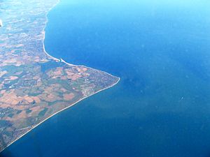
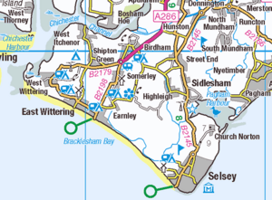
The Manhood Peninsula is a piece of land in the southwest of West Sussex, England. It has the English Channel to its south. To the north is the city of Chichester.
The peninsula is surrounded by water on three sides. Chichester Harbour is to its west. Pagham Harbour is to its east. The very tip of the southern coast is called Selsey Bill.
Long ago, this area, including some land further inland, was known as the Hundred of Manwood. The name "Manhood" actually comes from this older word. This "Hundred" system was set up when the Anglo-Saxons ruled England. It had its own local courts and government. Over time, this system changed. It was finally stopped by the English Parliament in the 1800s.
Contents
What's in a Name? The Manhood's History
The name of the peninsula has changed a bit over the years. The way it was spelled and even how the third letter sounded varied.
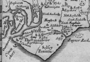
For example, on a map from 1587, it was called Manwed. A map from 1663 showed it as Manhode. Then, in 1695, Morden's map called it Manhope.
The name likely comes from an old English word, gemǣnewudu. This word meant "woodland held in common." This means it was a forest area that everyone in the community could use. This shared woodland stayed that way until 1793. That's when about 693 acres (2.80 km2) of it became private land. This happened because of special laws passed by Parliament.
A Look Back: The Manhood's Past
The Manhood Peninsula was a big part of the Hundred of Manwood. This hundred was located in the Rape of Chichester. A "Rape" was a special way that the county of Sussex was divided up.
Early Days: Saints and Kings
Around AD 681, a saint named Wilfrid came to the land of the South Saxons. He spent five years teaching people about Christianity. The king of the South Saxons, Æthelwealh, gave land on the Manhood to Wilfrid.
Soon after, the Kingdom of Wessex conquered the South Saxons. Their king, Cædwalla, confirmed the land gift. This gift of 87 "hides" (a measure of land) helped Wilfrid start a local monastery, Selsey Abbey.
There's an old document about this land gift from AD 673 (or maybe 683). However, historians think it might have been made up later, in the 900s. It's believed this fake document was created to help a bishop named Brihthelm. He wanted to get back land on the Manhood that someone else had taken.
Norman Times and Local Government
After the Normans took over England, the area became a "barony." This meant the Bishop of Chichester had special rights. He could even sit in Parliament as a peer.
The "Hundred" was an old way of organizing local areas. When the Domesday Survey was done, Sussex had 59 hundreds. Each hundred in Sussex was quite small, about 25 square miles (65 km2). In other parts of England, hundreds could be much larger.
During Norman times, hundreds had to pay a land tax called "geld." To figure out how much everyone owed, the king sent officials to each county. They worked with the county's sheriff and local knights. Two knights from each hundred would help. After the tax was set, these knights and the hundred's bailiff (an official) collected the money. They then sent it to the sheriff, who sent it to the king's treasury.
The Hundred Courts
From perhaps the 900s onwards, Manwood had its own hundred court. This court handled local issues, much like a local council today. It helped solve arguments and managed roads.
At the time of the Domesday Survey, the Hundred was known by two names: Westeringes and Somerley. A powerful lord named Earl Roger of Montgomery held the Hundred of 'Westeringes'. This included Birdham, Itchenor, Somerley in East Wittering, and West Wittering. The Bishop of Chichester held the Hundred of Somerley. This included land in Selsey, Sidlesham, and West Wittering.
By the 1100s, these two hundreds joined to become the Hundred of Manwood. It was a "liberty" of the Bishop of Chichester. This meant the Bishop had special control over the land. This land was the same land originally given to St Wilfrid by King Cædwalla.
The Bishop of Chichester's hundred court met several times a year. It also managed common land and rights to the foreshore (the land between high and low tide). Representatives from different areas, called "tithings," attended these meetings. These areas included West Wittering, Birdham, East Wittering, Selsey, and others. This continued until about 1835. The meetings likely took place at a special meeting place called the "hundred-moot" at Hundredsteddle Farm near Birdham. The name Hundredsteddle probably refers to the platform where the court sat.
In 1561, Queen Elizabeth I passed a law. This law took some church lands (called rectories) away from the Bishop of Chichester. These lands were often sold to private owners. For example, Sir William Morley (1606-1658) bought the rectory of Selsey for £4,100 in 1635.
Villages in the Manhood Hundred
Here are the villages that were part of the Hundred of Manwood, later called Manhood:
- Birdham
- Earnley
- East Wittering
- Selsey
- Sidlesham
- West Itchenor
- West Wittering
Some smaller areas, like East Itchenor and Almodington, were never full parishes. They were just small church areas called "chapelries." Bracklesham, which was mostly washed away by the sea, became part of East Wittering in 1518. For tax purposes, the hundred was divided into four main areas: Sidlesham, Selsey, Wittering, and Birdham.
The Manhood Today
The old "Hundred" system, as a way of governing, became less important in the 1800s. Today, the Manhood Peninsula is managed by Chichester District Council. The villages and towns on the peninsula also have their own local councils.
Many groups and businesses on the Manhood Peninsula use "Manhood" in their names. Some organizations work to solve common problems for everyone living there. One example is the Manhood Peninsula Partnership. This group was started in 2001 by local people. It brings together communities, government agencies, and other groups to help the Manhood area.
A large project called the Medmerry managed realignment scheme was finished in 2013. This project helps protect the coast from flooding. It allows a certain area near the sea to flood on purpose. This protects the town of Selsey and other buildings further inland. This new wetland area has also created new places for tourists and a home for wildlife.
Studies by Princeton University and McGill University show that the Manhood Peninsula is at high risk of flooding. Much of the land is less than 5 metres (16 ft) above sea level. Experts believe that without better sea defenses, parts of the area could be underwater by 2050. By 2100, larger areas, including the Witterings, Bracklesham, Selsey, Birdham, Almodington, and Sidlesham, could be permanently flooded. Chichester District Council is working on plans to deal with this flood risk.
See also
- Hundred of Manhood and Selsey Tramway
- List of hundreds of England and Wales
 | Delilah Pierce |
 | Gordon Parks |
 | Augusta Savage |
 | Charles Ethan Porter |


