East Wittering facts for kids
Quick facts for kids East Wittering |
|
|---|---|
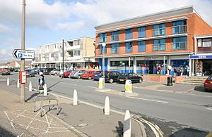
 East Wittering shops |
|
| Population | 4,658 (2011.Civil Parish) |
| OS grid reference | SZ795972 |
| • London | 60 miles (97 km) NNE |
| Civil parish |
|
| District |
|
| Shire county | |
| Region | |
| Country | England |
| Sovereign state | United Kingdom |
| Post town | CHICHESTER |
| Postcode district | PO20 |
| Dialling code | 01243 |
| Police | Sussex |
| Fire | West Sussex |
| Ambulance | South East Coast |
| EU Parliament | South East England |
| UK Parliament |
|
| Website | http://www.ewbpc.org.uk/ |
East Wittering is a large village located right by the sea in West Sussex, England. It's part of the Chichester area. Most of the village is in the civil parish of East Wittering and Bracklesham. A small part on the west side is in the West Wittering parish.
The village is about 7 miles southwest of Chichester. It sits on the B2179 road, on a piece of land called the Manhood Peninsula.
Contents
History of East Wittering
People have lived in East Wittering for more than a thousand years. The Witterings were first mentioned in official records in the late 600s. This was when the land was given to a bishop named Wilfrid.
The village is also in the Domesday Book from 1086. This book was a huge survey of England ordered by King William the Conqueror. It helped him know what land and resources he had.
For many centuries, a family called Wystryng owned the land in East Wittering. They even took their name from the village!
The original church, built in the 1100s, was called the Church of the Assumption of St Mary the Virgin. It was replaced by a newer church, St Anne's Church. St Anne's was built in the village center in the 1950s. The old church was no longer used after 1983.
In Victorian times, the RNLI (a charity that saves lives at sea) had a rescue boat here. Today, the Fire Service handles similar emergencies. In the last century, more holidaymakers started visiting the area.
In May 1944, East Wittering played a secret role in World War II. It was used as a practice landing beach for Canadian soldiers. This was a dummy run for D-Day, called Operation Fabius.
After the war, East Wittering became a quiet place again. It has a small primary school and is popular with surfers. A famous expert named Nikolaus Pevsner once described the village. He said it was "a jumble of bungalows and chalets near the beach."
St Anne's Anglican Church was designed by an architect named Harry Sherwood. He also worked on Chichester Cathedral. The church's first stone was laid on June 6, 1958. The Bishop of Chichester officially opened it on May 14, 1959.
Inside the church, there is a special plaque. It says that no lives were lost from this village during World War I (1914–1918). This makes East Wittering one of the very rare "Thankful Villages" in England. These are places where every soldier who went to war came home safely.
Surfing in East Wittering
The whole area of Bracklesham Bay is a very popular spot for surfers. The beach here slopes gently, and there are no dangerous currents or obstacles. This makes it a great place for people who are just learning to surf. East Wittering is also home to one of the UK's oldest surf clubs, Shore Surf Club.
How East Wittering is Governed
East Wittering has an "electoral ward" with the same name. An electoral ward is an area that elects its own representatives to a local council. This ward includes East Wittering and the areas around it. In 2011, the total population of this ward was 5,117 people.
Important Landmarks
- A war memorial stands at the eastern meeting point of the B2179 and Cakeham roads. This memorial mentions that East Wittering is a "Thankful Village." This special memorial, costing £25,000, replaced an older, smaller one. It was officially opened in September 2015.
Getting to East Wittering
You can reach East Wittering by car in a few ways. One common route is to take the A286 road from Chichester to Birdham. Then, you take the B2198 road to Bracklesham, and finally the B2179 road.
Another option is to take the B2179 road from Birdham. This route is a bit longer and goes through West Wittering. The B2179 road goes around the edge of the village center, which is on Cakeham Road.
East Wittering also has a regular bus service. Buses run frequently from Chichester and Birdham. They travel in a loop around Birdham, Bracklesham, East Wittering, and West Wittering. This loop is formed by the B2198 and B2179 roads.
See also
 In Spanish: East Wittering para niños
 | Mary Eliza Mahoney |
 | Susie King Taylor |
 | Ida Gray |
 | Eliza Ann Grier |


