Mapleview, Minnesota facts for kids
Quick facts for kids
Mapleview, Minnesota
|
|
|---|---|

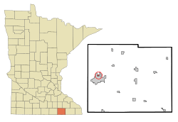
Location in Mower County and the state of Minnesota
|
|
| Country | United States |
| State | Minnesota |
| County | Mower |
| Area | |
| • Total | 0.18 sq mi (0.48 km2) |
| • Land | 0.18 sq mi (0.48 km2) |
| • Water | 0.00 sq mi (0.00 km2) |
| Elevation | 1,198 ft (365 m) |
| Population
(2020)
|
|
| • Total | 144 |
| • Density | 778.38/sq mi (300.06/km2) |
| Time zone | UTC-6 (Central (CST)) |
| • Summer (DST) | UTC-5 (CDT) |
| ZIP Code |
55912
|
| Area code(s) | 507 |
| FIPS code | 27-40346 |
| GNIS feature ID | 2395845 |
Mapleview is a small city in Mower County, Minnesota, United States. It is located in Lansing Township. Mapleview is like a neighbor to Austin, which is the main city (county seat) of Mower County. In 2020, about 144 people lived there. The city got its name from a line of maple trees that used to grow on its western side.
Contents
History of Mapleview
Mapleview became an official village in 1945. This was done to help about 100 families living there. In 1948, the city bought land north of town. Over time, a liquor store, fire station, water tower, and equipment garages were built there.
In 1954, Mapleview bought a piece of land next to Murphy Creek. This area became Hillside Park, a nice place for people to enjoy. The fire station was built in 1958. Today, it has two fire trucks and 13 volunteer firefighters. Michael Langstaff is the Fire Chief.
In 1962, homes in Mapleview got access to Natural gas. This made heating and cooking easier for residents. For many years, Mapleview shared a police department with the city of Lyle. This shared police service ended in 2013.
Where is Mapleview?
Mapleview is in the western part of Mower County. The city of Austin surrounds it on the south, east, and west sides. Oakwood Cemetery is just south of Mapleview's border with Austin. Austin's Wildwood Park is also nearby, to the southeast.
The Cedar River flows through the eastern part of Mapleview. Murphy Creek, which is a smaller stream, crosses the western part of the city. All the land in Mapleview is about 0.48 square kilometers (0.18 square miles). The water from Mapleview flows into the Iowa River.
County Road 45 is an important road that goes through Mapleview. A major highway, Interstate 90, is only about half a mile south of the city. Also, U.S. Highway 218 is less than a mile to the west.
People in Mapleview
| Historical population | |||
|---|---|---|---|
| Census | Pop. | %± | |
| 1950 | 435 | — | |
| 1960 | 381 | −12.4% | |
| 1970 | 328 | −13.9% | |
| 1980 | 253 | −22.9% | |
| 1990 | 206 | −18.6% | |
| 2000 | 189 | −8.3% | |
| 2010 | 176 | −6.9% | |
| 2020 | 144 | −18.2% | |
| U.S. Decennial Census | |||
The population of Mapleview has changed over the years. In 1950, there were 435 people. By 2020, the population was 144.
2010 Census Information
According to the census from 2010, there were 176 people living in Mapleview. These people lived in 83 households, and 44 of these were families. The city had 93 housing units in total.
Most of the people in Mapleview were White (90.3%). There were also people of Asian background and other races. About 14.2% of the population identified as Hispanic or Latino.
In 2010, about 22.9% of households had children under 18 living with them. Many households were married couples. Some households were led by a single parent, either a mother or a father. About 34.9% of all households were individuals living alone. Some of these individuals were 65 years old or older. The average household had about 2.12 people.
See also
 In Spanish: Mapleview (Minnesota) para niños
 | Laphonza Butler |
 | Daisy Bates |
 | Elizabeth Piper Ensley |

