Marlborough (CDP), New Hampshire facts for kids
Quick facts for kids
Marlborough, New Hampshire
|
|
|---|---|

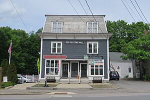
Odd Fellows Hall
|
|
| Country | United States |
| State | New Hampshire |
| County | Cheshire |
| Town | Marlborough |
| Area | |
| • Total | 1.69 sq mi (4.37 km2) |
| • Land | 1.69 sq mi (4.37 km2) |
| • Water | 0.00 sq mi (0.00 km2) |
| Elevation | 800.5 ft (244.0 m) |
| Population
(2020)
|
|
| • Total | 1,066 |
| • Density | 631.89/sq mi (243.99/km2) |
| Time zone | UTC-5 (Eastern (EST)) |
| • Summer (DST) | UTC-4 (EDT) |
| ZIP code |
03455
|
| Area code(s) | 603 |
| FIPS code | 33-45380 |
| GNIS feature ID | 2378080 |
Marlborough is a small community, also called a census-designated place (CDP). It's the main village within the larger town of Marlborough in Cheshire County, New Hampshire, United States. In 2020, about 1,066 people lived in this part of Marlborough. The entire town had a population of 2,096 people.
Contents
Where is Marlborough Located?
Marlborough CDP is in the northwest part of the town of Marlborough. It sits in a valley near Minnewawa Brook. This brook flows west and is part of the Connecticut River watershed. The CDP shares borders with Keene to the northwest and Swanzey to the west.
The southern edge of Marlborough CDP follows streets like Laurel Street and Ryan Road. Its eastern border is along New Hampshire Route 101 and Roxbury Road. The northern border goes west towards the Keene town line.
Main Roads in Marlborough
New Hampshire Route 101 is Marlborough's Main Street. It goes east about 15 miles to Peterborough. If you go west, it's about 5 miles to Route 9 in Keene. Another road, Route 124, starts in the center of Marlborough CDP. It heads southeast about 12 miles to Jaffrey.
Land Area
The Marlborough CDP covers an area of about 4.4 square kilometers (1.7 square miles). All of this area is land, with no large bodies of water inside the CDP.
Who Lives in Marlborough?
The population of Marlborough CDP has changed over the years. Here's how many people lived there in different census years:
| Historical population | |||
|---|---|---|---|
| Census | Pop. | %± | |
| 1950 | 1,116 | — | |
| 1960 | 1,097 | −1.7% | |
| 1970 | 1,231 | 12.2% | |
| 1980 | 1,184 | −3.8% | |
| 1990 | 1,211 | 2.3% | |
| 2000 | 1,089 | −10.1% | |
| 2010 | 1,094 | 0.5% | |
| 2020 | 1,066 | −2.6% | |
| U.S. Decennial Census | |||
Population Details (2010)
In 2010, there were 1,094 people living in Marlborough CDP. They lived in 457 households, and 282 of these were families. Most residents (96.6%) were White. A small number of people were African American (0.6%) or Asian (0.6%). About 1.1% of the population identified as Hispanic or Latino.
About 28.4% of households had children under 18 living with them. Many households (42.5%) were married couples. About 13.3% of households had a female head with no husband present.
The average household had about 2.39 people. The average family had about 2.85 people.
Age and Income
In Marlborough CDP, about 21.2% of people were under 18 years old. About 17.4% were 65 years or older. The average age was around 40.1 years.
From 2011 to 2015, the estimated average yearly income for a household was about $44,391. For families, the average income was about $54,038. The per capita income (income per person) was $27,466. About 13.3% of the population lived below the poverty line.
See also
 In Spanish: Marlborough (condado de Cheshire) para niños
 | Stephanie Wilson |
 | Charles Bolden |
 | Ronald McNair |
 | Frederick D. Gregory |


