
Masada facts for kids
|
מצדה
|
|

An aerial view of Masada, from the north
|
|

Location in Israel
|
|
| Location | Southern District, Israel |
|---|---|
| Region | Judaean Desert |
| Coordinates | 31°18′56″N 35°21′14″E / 31.31556°N 35.35389°E |
| Type | Fortification |
| History | |
| Builder | Alexander Jannaeus (?) Herod the Great |
| Founded | 1st century BC |
| Events | Siege of Masada |
| Site notes | |
| Excavation dates | 1963–1965 |
| Archaeologists | Yigael Yadin |
| UNESCO World Heritage Site | |
| Criteria | Cultural: iii, iv, vi |
| Inscription | 2001 (25th Session) |
| Area | 276 ha |
| Buffer zone | 28,965 ha |
Masada (which means 'fortress' in Hebrew) is an ancient mountain-top fortress. It sits high above the western shore of the Dead Sea in southeastern Israel. This amazing fort was built in the first century BC. It stands on a natural flat-topped mountain, rising over 400 meters (1,300 feet) above the land around it.
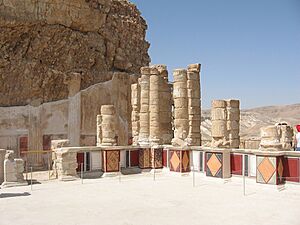
The most important parts of Masada that we can still see today were built by Herod the Great. He was King of Judaea from about 37–4 BC. Herod turned Masada into a strong desert hideaway early in his rule. He built a thick wall with towers around the top of the mountain. He also added storerooms, a clever water system, and fancy bathhouses. There were even two grand palaces, one on the west side and another on the northern cliff. These palaces are still great examples of Herod's building style.
Masada is most famous for its role in the First Jewish–Roman War (66–73 AD). It became the last place where Jewish rebels held out after Jerusalem was destroyed. A group called the Sicarii, led by Eleazar ben Ya'ir, defended Masada. They fought against the powerful Roman Tenth Legion. In modern times, the story of Masada has become a symbol of bravery for the people of Israel.
Archaeologist Yigael Yadin led excavations at Masada in the 1960s. His team found incredibly well-preserved remains. These included Herod's palaces, storerooms with old food, ritual baths, a synagogue, and even ancient scrolls. They also found pottery pieces with names on them, including one that said "ben Ya'ir." This might have been the leader of the defenders. The Roman siege works, like their camps and walls, are still visible. They are some of the best examples of Roman military engineering we have. Today, Masada is a UNESCO World Heritage Site. It is also one of Israel's most popular tourist spots, with about 750,000 visitors each year.
Contents
Masada's Amazing Geography
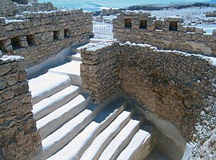
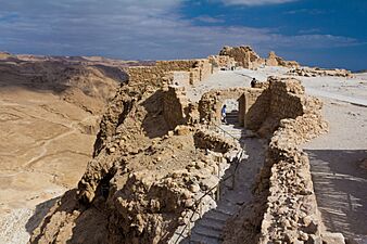
The Masada cliff is like a giant block of rock that was pushed up from the earth. It has steep cliffs that drop about 400 meters (1,300 feet) on the east side. On the west, they drop about 90 meters (300 feet). This makes it very hard to reach the fortress naturally. The top of the mountain is flat and shaped like a diamond, about 550 meters (1,800 feet) long and 270 meters (890 feet) wide. Herod built a 4-meter (13-foot) high wall around the plateau. This wall was 1,300 meters (4,300 feet) long and had many towers.
The fortress had storerooms, places for soldiers to live, a weapons room, and a palace. It also had many large cisterns (water tanks). These cisterns could hold about 40,000 cubic meters (1.4 million cubic feet) of water. They were filled by rainwater. It's said that just one day's rain could collect enough water to keep over 1,000 people alive for two to three years! Only three narrow, winding paths led up to the fortified gates of the fortress.
A Look at Masada's History
Most of what we know about Masada comes from Josephus. He was a Jewish-Roman historian from the first century. Masada is also mentioned in some of the Judean Desert Documents.
Early Fortifications
Josephus wrote that the site was first fortified by a Hasmonean ruler named Alexander Jannaeus. This happened in the first century BC. However, archaeologists have not yet found any buildings from that exact time.
Josephus also wrote that Herod the Great took control of Masada around 43 BC. This was during a power struggle after his father died. Masada survived a siege by the last Hasmonean king, Antigonus II Mattathias.
Herod's Grand Fortress

According to Josephus, Herod the Great built a huge fortress on the plateau. This was between 37 and 31 BC. He planned it as a safe place for himself if there was a revolt. He also built two palaces and made sure there was an endless supply of food.
The Great Jewish-Roman War
In 66 CE, a group of Jewish rebels called the Sicarii took over Masada. They used a clever trick to defeat the Roman soldiers stationed there. Josephus described the Sicarii as an extreme Jewish group. They were different from the larger group of Jewish rebels called the Zealots. Josephus said the Sicarii attacked nearby Jewish villages, including Ein Gedi.
In 73 AD, the Roman governor, Lucius Flavius Silva, led the Roman legion X Fretensis to besiege Masada. The Roman army surrounded Masada. They built a wall around it and then a massive ramp against the western side of the mountain. This ramp was about 114 meters (375 feet) high. It was mostly made of a natural rock spur.
The ramp was finished in the spring of 73 AD, after about two to three months of siege. This allowed the Romans to break through the fortress wall with a battering ram on April 16. The Romans used about 15,000 soldiers, including auxiliary units and Jewish prisoners. They crushed the Jewish resistance at Masada.
A giant siege tower with a battering ram was built and slowly moved up the ramp. Josephus wrote that when Roman troops entered the fortress, they found something shocking. The defenders had set fire to all the buildings except the food storerooms. In total, 960 men, women, and children died. Josephus wrote about two powerful speeches the Sicarii leader gave to convince his people to take their own lives. Only two women and five children were found alive.
Josephus likely based his story on reports from the Roman commanders. There are some differences between what Josephus wrote and what archaeologists found. For example, Josephus mentioned only one palace, but two have been found. He also claimed 960 people died, but remains of at most 28 bodies have been found. However, some details Josephus gave were correct. He described the baths and the colorful mosaic floors, which Yadin's team later found.
A Monastery on the Mountain
Masada was last used during the Byzantine period. A small church was built there. This church was part of a monastery known as Marda. This name means "fortress" in Aramaic.
Discovering Masada's Secrets
Ancient Seeds
In a hard-to-reach cave on Masada's southern cliff, scientists found ancient plant remains. Among them were 6,000-year-old barley seeds. These seeds were so well-preserved that their DNA could be studied. This was the first time such an old plant genome was sequenced. It helped scientists learn that barley was first grown by people further north in the Jordan Rift Valley.
Modern Exploration
Americans Edward Robinson and Eli Smith first identified Masada in 1838. In 1842, Samuel W. Wolcott and W. Tipping were the first modern people to climb it. Shmarya Guttman did the first small excavation in 1959.
Yigael Yadin's Expedition

Israeli archaeologist Yigael Yadin led a big excavation of Masada from 1963 to 1965. Because Masada is far from towns and in a dry desert, it remained mostly untouched for 2,000 years.
Many of the old buildings have been rebuilt from their remains. This includes the wall paintings of Herod's palaces and the Roman-style bathhouses. The synagogue, storerooms, and homes of the Jewish rebels have also been found and restored.
The water cisterns, located two-thirds of the way up the cliff, collected water from nearby dry riverbeds. This explains how the rebels had enough water for so long.
The Roman attack ramp still stands on the western side. You can even climb it today. The meter-high wall the Romans built around Masada is also visible. Eight Roman siege camps are just outside this wall. These Roman siege structures are the best preserved of their kind. This is one reason Masada is a UNESCO World Heritage site.
Yadin wrote a book about Masada in 1966 for everyone to read.
Amazing Finds
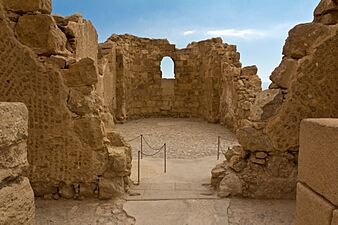
Inside the synagogue, archaeologists found a pottery shard with "tithe for the priest" written on it. They also found pieces of two scrolls: parts of Deuteronomy and the Book of Ezekiel. These were hidden under the floor of a small room in the synagogue. Other finds included parts of the books of Genesis, Leviticus, Psalms, and Sirach.
Near the Northern Palace, 11 small pottery shards were found, each with a single name. One said "ben Ya'ir," which might be short for Eleazar ben Ya'ir, the leader of the fortress. The other 10 names might belong to the men chosen to kill the others and then themselves, as Josephus described.
Human Remains
.jpg)
The remains of a maximum of 28 people were found at Masada. The skeletons of 25 people were found in a cave below the southern wall. The remains of two males and one female were found in the bathhouse of the Northern Palace.
The rabbinical leaders decided that the remains in the cave belonged to the Jewish defenders. In July 1969, they were reburied in a state ceremony. However, carbon dating of textiles found with the remains suggests they are from the time of the revolt. Also, pig bones were found, which sometimes happened in Roman burials. This suggests the remains might belong to non-Jewish Roman soldiers or civilians who were at the site.
An Ancient Date Palm Seed
A 2,000-year-old Judean date palm seed was found during excavations in the 1960s. It was successfully grown into a date plant! This plant is famously known as "Methuselah" after a very long-living person in the Hebrew Bible. This was the oldest known seed germination at the time. As of 2024, it is still the oldest germination from a seed.
Byzantine Church
The remains of a Byzantine church from the fifth and sixth centuries have been found on the plateau.
Masada's Building Phases
Masada is a great example of Herod's building style. It was the first place he fortified after becoming king.
First Building Phase
The first phase of building by Herod started in 35 BC. During this time, the Western Palace was built. Three smaller palaces, a storeroom, and army barracks were also constructed. Three pigeon towers and a swimming pool at the south end were also completed.
The main part of the Western Palace was square. You entered through an open courtyard. This courtyard led to a reception area and then to the throne room. The king had a private dressing room off the throne room. There was also a mosaic room with steps to a second floor for the king and queen's bedrooms.
Second Building Phase
The second building phase was in 25 BC. This included an addition to the Western Palace. A large storage complex for food and the Northern Palace were also built. The Northern Palace is one of Herod's most luxurious palace-fortresses. It was built on the northern side of Masada and goes down two levels over the cliffs. The top level had living quarters for the king and a curved porch with great views. A staircase led down to the middle level, which was a fancy circular reception hall. The lower level was also for parties and banquets. It had porches on all sides and a Roman bathhouse.
Third Building Phase
In 15 BC, during the third and final building phase, almost all of Masada was enclosed by a casemate wall. This was a double wall with rooms in between. These rooms were used by soldiers and for extra storage. The Western Palace was also made bigger to add more rooms for servants.
| Site Plan | |
|---|---|
 |
A. ostraca cache found in casemate B. Herod's throne room C. colorful mosaic D. Roman breaching point E. coin cache found F. ostraca cache found G. three skeletons found |
Visiting Masada Today
Masada was named a UNESCO World Heritage Site in 2001. In 2007, the Masada Museum opened. It shows off archaeological finds in a fun, theatrical way. Many items were found by Yadin's team in the 1960s.
_on_the_Dead_Sea,_Edward_Lear,_1858.jpg)
The archaeological site is part of the Masada National Park. You need to pay an entrance fee to get in. There are two very steep hiking paths:
- The Snake Trail starts on the eastern side near the Masada Museum. It climbs about 301 meters (988 feet).
- The Roman Ramp trail is also steep but has less climbing. You can reach it from the western side of the mountain.
Many hikers start an hour before sunrise to avoid the hot midday sun. The paths are often closed in summer because of the extreme heat. Remember to bring plenty of water, as it's only available at the top.
If you prefer, you can take a cable car to the top. It opens at 8 am. A visitors' center and the museum are at the bottom of the cable car. On some summer nights, there's a cool light-and-sound show on the western side of the mountain.
The Masada Story and Its Meaning
The Masada story is often seen in modern Israel as "a symbol of Jewish heroism." It represents the bravery of the Masada warriors. It shows their strength in holding Masada for almost three years. It also shows their choice of death over slavery when fighting a powerful empire. Masada has become a special place for national heritage and military ceremonies.
Masada in the Israeli Army

The head of the Israel Defense Forces (IDF), Moshe Dayan, started a tradition. Soldiers finishing their basic training would have their swearing-in ceremony on top of Masada. The ceremony ends with the declaration: "Masada shall not fall again." Soldiers climb the Snake Path at night, and the ceremony is lit by torches.
Masada in Pop Culture
- A miniseries about the fortress was shown in 1981.
- Masada was a featured location in The Amazing Race Australia 1 (2011).
- In 2017, Jean Michel Jarre performed an electronic music concert near the fortress.
- Masada is a main location in the fourth season of Preacher.
- Masada is the main location for the novel The Dovekeepers and the TV show of the same name.
- "Masada" is the title of a song and album by Ivorian reggae singer Alpha Blondy.
Images for kids
-
The Northern Palace's lower terrace (#39 on plan)
-
Stepped pool interpreted by Yadin as a Herodian swimming pool, possibly used as a public ritual immersion bath (mikveh) by the rebels (#17 on plan)
-
Byzantine church (#26 on plan)
-
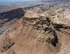
Aerial view showing Masada and the Snake Path from the northeast
-
Masada's western Byzantine gate (#23 on plan)
-

Roman siege camp F and section of the Roman circumvallation wall
-

Cable car (Masada cableway) heading down from Masada


_-_Masada_(1).jpg)


See also
 In Spanish: Masada para niños
- Masada myth
- Archaeology of Israel
- Tourism in Israel
