Matamec River facts for kids
Quick facts for kids Matamec River |
|
|---|---|

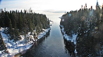
The river looking south from Quebec Route 138 in December 2011
|
|
| Other name(s) | Rivière Matamec |
| Country | Canada |
| Province | Quebec |
| Region | Côte-Nord |
| RCM | Sept-Rivières |
| Physical characteristics | |
| River mouth | Gulf of Saint Lawrence 0 metres (0 ft) 50°17′01″N 65°58′00″W / 50.2836111°N 65.9666667°W |
| Length | 66.5 kilometres (41.3 mi) |
| Basin features | |
| Basin size | 679 square kilometres (262 sq mi) |
The Matamec River (French: Rivière Matamec) is a special river in the Côte-Nord region of Quebec, Canada. It flows into the Gulf of Saint Lawrence. This river was important for studying Atlantic salmon and brook trout. Scientists from the Woods Hole Oceanographic Institution (WHOI) did research here from 1966 to 1984. Today, the southern part of the river's area is strictly protected as the Matamec Ecological Reserve.
Contents
Exploring the Matamec River
The Matamec River is about 66.5 kilometres (41.3 mi) long. It starts near Lake Cacaoni and flows from north to south. The river passes through Lake Matamec, which is less than 10 kilometres (6.2 mi) from where it meets the sea. This river is known for having lots of fish. The river's mouth is in the town of Sept-Îles. It flows into Moisie Bay, near the small community of Matamec.
What's in a Name?
The name "Matamec" comes from the Innu language word matamek. This word means "trout." An old map from 1865 showed the Matamek River as the eastern border of the Moisie area. The official name "Matamek River" was set in 1916. Later, in the early 1960s, the name changed slightly to "Matamec River."
The Matamec River Basin
The area drained by the Matamec River, called its basin, covers 679 square kilometres (262 sq mi). This basin is located between the Moisie River to the west and the Loups Marins River to the east. Parts of the basin are in the wild area of Rivière-Nipissis. Other parts are within the municipality of Sept-Îles.
Geology of the Basin
The land here is part of the Precambrian shield, which is very old rock. Close to the coast, the bedrock is covered by sand and clay left by the sea. Further inland, the bedrock is often close to the surface. The rocks here include gneiss, granite, and other types of metamorphic and igneous rocks.
Thousands of years ago, this area was covered by a thick ice sheet. When the ice melted around 9,000 years ago, it left behind deposits of glacial till. After the ice retreated, the southern part of the basin was covered by the Goldthwait Sea. As the land slowly rose from the weight of the ice, the sea pulled back. This left behind sea clay in the low areas, often now covered by ombrotrophic peat bogs.
Lakes and Tributaries
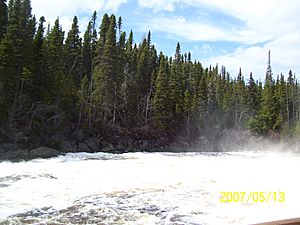
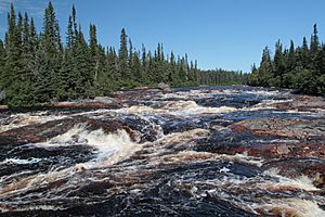
The Matamec watershed has 31 lakes, ponds, and bogs. The rivers and lakes often follow cracks and breaks in the bedrock. They are usually surrounded by steep, rocky hills. The main rivers that flow into the Matamec are the Tchinicanam and Rats-Musqués rivers. There are five waterfalls in the 10 kilometres (6.2 mi) stretch of the river between Matamec Lake and the Gulf. Important lakes include Lake Matamec and Lake La Croix. Lake Matamec is 105 metres (344 ft) deep.
Climate and Nature
The average yearly temperature in the Matamec basin is very cold, ranging from −1.5 to −1.9 °C (29.3 to 28.6 °F). The area is part of the boreal forest. You can find old, untouched forests of black spruce (Picea mariana) and balsam fir (Abies balsamea) here.
People and the Matamec River
In 1912, Walter Amory and his son Copley Amory bought land at the river's mouth. Copley Amory, who was American, started a boat-building company where the small community of Matamec is today. Some families moved there to work at the factory. There was even a post office from 1917 to 1941.
Walter Amory was a naturalist, someone who studies nature. He was very interested in how the numbers of fish and game animals changed. These changes sometimes made life very hard for the local Innu people. In 1931, Amory invited important scientists to a meeting called the Matamek Conference on Biological Cycles. Charles Sutherland Elton, a famous ecologist, was one of them. Amory's support helped Elton start the Bureau of Animal Population at the University of Oxford.
In the mid-1930s, Amory had to stop his work at Matamec because of money problems. The property was eventually sold and became a fishing camp for people who liked to fish. It had a lodge and cabins for visitors. W. Gallienne was the first owner after Amory, and he later sold it to J. Seward Johnson. In 1966, Johnson gave about 150 acres (61 ha) of land at the river's mouth to the Woods Hole Oceanographic Institution (WHOI).
Protecting the Matamec River
The Woods Hole Oceanographic Institution (WHOI) got the land at the river mouth in 1966. They wanted to do experiments with salmon and trout. Also in 1966, the Quebec government created the Matamek River Reserve. This reserve limited public access and helped protect Atlantic salmon and brook trout.
In 1970, the entire Matamec river basin became a reserve. This meant that hunting and fishing were only allowed for research. The Innu people could still use their traditional trapping rights. WHOI first studied salmon in the lower river and Matamec Lake. Then, they expanded their research to include brook trout in other parts of the watershed. They also studied salmon in the nearby Moisie and Corneille rivers. Their research also looked at lakes, sediments, water flow, and the physical geography of the area. During this time, the government built a special "salmon-pass" on the Matamec River to help fish move upstream.
Woods Hole closed their research station at the end of 1984. They left partly because of money issues. They also wanted to focus more on their main goal of oceanography. They tried to find a Canadian group to take over the station and continue the research, but they couldn't. When the research stopped, the basin could then be opened up for logging.
In 1975, Woods Hole and INRS-eau suggested creating an ecological reserve. Twenty-five years later, the southern part of the watershed became an ecological reserve. This reserve is mostly covered by untouched forest or wetlands and covers 184.86 square kilometres (71.37 sq mi). This is a little more than a quarter of the entire watershed. As of 2015, the Matamec Ecological Reserve has very strict protection. There are also plans for another protected area in the northern part of the river. Another proposed area would allow careful, sustainable use of the environment.
 | John T. Biggers |
 | Thomas Blackshear |
 | Mark Bradford |
 | Beverly Buchanan |


