
Mbabane facts for kids
Quick facts for kids
Mbabane
|
|
|---|---|

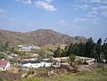
Panoramic view of Mbabane
|
|

Mbabane
Location in Eswatini

Mbabane
Location in Africa
|
|
| Country | |
| District | Hhohho |
| Founded | 1902 |
| Area | |
| • Total | 81.76 km2 (31.57 sq mi) |
| Elevation | 1,243 m (4,078 ft) |
| Population
(2010)
|
|
| • Total | 94,874 |
| • Density | 1,160.40/km2 (3,005.41/sq mi) |
| Time zone | UTC+02:00 (South African Standard Time) |
| • Summer (DST) | (Not Observed) |
| Postal code |
H100
|
| Climate | Cwb |
Mbabane is the largest city in Eswatini, a country in Southern Africa. It used to be called Swaziland. Mbabane is one of the two capitals of Eswatini, serving as the main government capital. The other capital is Lobamba.
About 94,874 people lived here in 2010. The city is located near the Mbabane River and its smaller river, the Polinjane River. It sits among the Mdzimba Mountains. Mbabane is in the Hhohho Region, and it is also the capital of this region. The city is about 1,243 meters (4,078 feet) above sea level. You can find it along the MR3 road.
Contents
History of Mbabane
The town of Mbabane started to grow after 1902. This was when the country's main government office moved here from a place called Bremersdorp (which is now known as Manzini). The city got its name from a chief named Mbabane Kunene. He lived in the area when British settlers first arrived.
Mickey Wells founded Mbabane in 1887. It was built where a route from Transvaal to Mozambique crossed the Mbabane River. In 1902, it was declared the capital of the new Protectorate of Swaziland. A protectorate is like a country that is protected and controlled by a stronger country.
At first, Mbabane had only a few shops, churches, and schools. These were started by white settlers. Initially, the town was mainly for white settlers, and Black Africans lived in nearby rural areas. By the 1930s, Mbabane had modern services like electricity, running water, telephone connections, and a hospital.
Before World War II, most people from Eswatini lived in the countryside. Many also worked outside the country. This meant the town did not grow much. After the war, things changed. New trade schools opened in the city. A railway line, called the Goba railway, connected Maputo to mines in South Africa. Also, foreign countries started investing money in Eswatini, especially in sugar production. All these things helped Mbabane grow a lot. It became the main center for development in the Hhohho district.
After Eswatini became an independent country, more government buildings were built in Mbabane. For example, the British Consulate was built here. The city has continued to grow because of its tourism industry. Mbabane is now a central place for tourists. It has many hotels and fun places like clubs and golf courses for visitors.
Mbabane's Economy
Mbabane is close to the Ngwenya-Oshoek border crossing with South Africa. While siSwati is the main language, English is also widely spoken. Mbabane, and Eswatini as a whole, rely on tourism and selling sugar to other countries.
The city is also a busy place for trade in the area around it. In the past, tin and iron were mined nearby. Mbabane also has two areas where smaller factories operate. The financial services sector is also very important in Mbabane. This includes banking, managing investments, and insurance. This growth has made Mbabane a key financial center in the region. It helps Eswatini's economy grow overall.
Education in Mbabane
Mbabane is home to several important schools and universities. One of them is the Waterford-Kamhlaba United World College of Southern Africa. It is also where one of the three campuses of the University of Eswatini is located. Another university, Limkokwing University of Creative Technology, is a private international university. It is located near the border between South Africa and Eswatini.
Culture in Mbabane
The Indingilizi Gallery is an art gallery in Mbabane. It was started in 1982. The gallery displays many types of Swazi art. You can see sculptures, paintings, batiks (a type of fabric art), mohair items, traditional jewelry, and pottery.
Places of Worship
In Mbabane, you can find various places of worship. Most of them are Christian churches. These include the Roman Catholic Diocese of Manzini (part of the Catholic Church), the Swaziland Reformed Church (part of the World Communion of Reformed Churches), and the Zion Christian Church. There are also Muslim mosques in the city.
Geography of Mbabane
Mbabane is located in the Hhohho district, where it serves as the capital. The city is built along the Mbabane River and its smaller branch, the Polinjane River. These rivers flow through the Mdzimba Mountains. The city's average height above sea level is 1,243 meters (4,078 feet). Some of the neighborhoods and suburbs in Mbabane include Mbangweni, Sidvwashini, Kent Rock, Sandla, Westridge Park, Malunge, New Checkers, Msunduza and Vukutentele.
Mbabane's Climate
Because Mbabane is high up, it has a mild subtropical highland climate. This type of climate is known as Cwb in the Köppen climate classification system. The city's weather is generally mild. Snow is very rare, having fallen only three times since 1900. On average, the city experiences only four days of frost each year.
The average temperature in July is about 11°C (52°F). In January, the average temperature is around 22°C (72°F). The temperature does not change much between day and night. However, winter nights can be quite cold for a subtropical climate. Most of the rain falls during the summer months. The difference in rainfall between the driest month (June) and the wettest month (January) is 210 mm (8.3 inches).
| Climate data for Mbabane (1961-1990 normals, extremes 1957-1977) | |||||||||||||
|---|---|---|---|---|---|---|---|---|---|---|---|---|---|
| Month | Jan | Feb | Mar | Apr | May | Jun | Jul | Aug | Sep | Oct | Nov | Dec | Year |
| Record high °C (°F) | 33.4 (92.1) |
32.2 (90.0) |
33.5 (92.3) |
31.0 (87.8) |
29.4 (84.9) |
26.8 (80.2) |
28.6 (83.5) |
31.2 (88.2) |
33.6 (92.5) |
34.2 (93.6) |
34.5 (94.1) |
32.4 (90.3) |
34.5 (94.1) |
| Mean daily maximum °C (°F) | 24.9 (76.8) |
24.5 (76.1) |
24.1 (75.4) |
22.6 (72.7) |
21.4 (70.5) |
19.3 (66.7) |
19.8 (67.6) |
21.3 (70.3) |
23.2 (73.8) |
22.8 (73.0) |
22.5 (72.5) |
23.7 (74.7) |
22.5 (72.5) |
| Daily mean °C (°F) | 19.9 (67.8) |
19.5 (67.1) |
18.8 (65.8) |
16.8 (62.2) |
14.7 (58.5) |
12.0 (53.6) |
12.2 (54.0) |
14.0 (57.2) |
16.4 (61.5) |
17.1 (62.8) |
17.7 (63.9) |
19.0 (66.2) |
16.5 (61.7) |
| Mean daily minimum °C (°F) | 14.9 (58.8) |
14.5 (58.1) |
13.4 (56.1) |
11.0 (51.8) |
7.9 (46.2) |
4.7 (40.5) |
4.6 (40.3) |
6.6 (43.9) |
9.5 (49.1) |
11.3 (52.3) |
12.9 (55.2) |
14.2 (57.6) |
10.5 (50.8) |
| Record low °C (°F) | 8.6 (47.5) |
6.4 (43.5) |
6.0 (42.8) |
3.4 (38.1) |
−1.3 (29.7) |
−4.5 (23.9) |
−6.1 (21.0) |
−2.5 (27.5) |
−1.0 (30.2) |
−1.0 (30.2) |
5.5 (41.9) |
6.6 (43.9) |
−6.1 (21.0) |
| Average rainfall mm (inches) | 253.2 (9.97) |
224.6 (8.84) |
151.6 (5.97) |
87.9 (3.46) |
33.8 (1.33) |
19.4 (0.76) |
20.1 (0.79) |
35.1 (1.38) |
69.4 (2.73) |
141.9 (5.59) |
197.8 (7.79) |
206.9 (8.15) |
1,441.7 (56.76) |
| Average rainy days | 16.9 | 14.3 | 13.8 | 9.8 | 5.1 | 2.8 | 3.1 | 6.5 | 9.2 | 14.9 | 17.0 | 16.5 | 129.9 |
| Mean monthly sunshine hours | 172.7 | 162.1 | 194.6 | 195.2 | 226.0 | 233.0 | 238.9 | 246.3 | 209.2 | 178.4 | 160.9 | 170.1 | 2,387.1 |
| Percent possible sunshine | 41 | 45 | 52 | 57 | 68 | 75 | 73 | 72 | 59 | 45 | 40 | 40 | 55 |
| Source 1: WMO | |||||||||||||
| Source 2: NOAA (extremes, sunshine 1970-1975) | |||||||||||||
International Connections
Twin Towns and Sister Cities
Mbabane has special partnerships with other cities around the world. These are called "twin towns" or "sister cities." These partnerships help cities share culture and ideas.
 Fort Worth, Texas, US
 Taipei, Taiwan
- Kaohsiung, Taiwan
 Mersing, Malaysia
 Melilla, Spain
 Maputo, Mozambique
Healthcare
- Young Heroes (organization) (2006) is an organization that helps children in Eswatini.
Images for kids
-
View of Mbabane
-
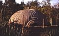
Portable market hut in Mbabane, 1979


See also
 In Spanish: Babane para niños
