
McArthur Lake (Saskatchewan) facts for kids
Quick facts for kids McArthur Lake |
|
|---|---|

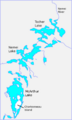
McArthur, Nemei and Tocher lakes drain into the Nemei River
|
|

McArthur Lake
Location in Saskatchewan
|
|
| Coordinates | 55°15′00″N 102°24′01″W / 55.2501°N 102.4004°W |
| Type | Lake |
| Basin countries | Canada |
| Surface elevation | 328 metres (1,076 ft) |
McArthur Lake is a beautiful lake located in Saskatchewan, Canada. It sits in a flat area of the Canadian Shield, which is a huge rocky region. The weather here is quite cold, like in the sub-arctic. Around the lake, you'll find many evergreen forests, along with some marshy areas called muskeg and rocky spots.
Where is McArthur Lake?
McArthur Lake is found at 55°15′00″N 102°24′01″W / 55.2501°N 102.4004°W. It is about 328 metres (1,076 ft) above sea level. Inside the lake, there is an island called Charbonneau Island.
This lake is located northwest of Flin Flon, a town in Manitoba. It's also east of Pelican Narrows, Saskatchewan. Water from McArthur Lake flows north into the Churchill River through the Nemei River.
The lake was named to honor Duncan Archibald McArthur. He was a soldier who sadly passed away on August 28, 1944. This happened during the invasion of Normandy in World War II.
What the Land Looks Like

The area around McArthur Lake, including Attitti Lake, is very flat. It's a typical part of the Canadian Shield. The hills here are not very tall, usually rising only about 100 to 150 feet (30 to 46 m) above the lakes.
The land has long, wavy ridges of rock sticking out. Between these ridges, you'll find marshy areas (muskeg), loose soil, and lakes. The rocks in this area are very old, from a time called the Precambrian era. They are mostly sedimentary rocks that have been changed by heat and pressure.
Near the northern part of McArthur Lake, there's a steep cliff. It's about 75 to 100 feet (23 to 30 m) high and runs along the east side of the lake.
Nature and Wildlife
McArthur Lake is in a subarctic climate zone. This means it gets very cold! The average temperature for the whole year is about −2 °C (28 °F). July is the warmest month, with an average of 16 °C (61 °F). January is the coldest, averaging −29 °C (−20 °F).
The lake is surrounded by thick forests of evergreen trees. The most common trees are black spruce, jack pine, and poplar. There are also some balsam trees. These trees usually grow taller than 20 feet (6.1 m). You can also find small patches of muskeg, which are wet, mossy areas. In these spots, you might see plants like laurel and labrador tea, along with a few larch and black spruce trees.
Many animals live in this area. People hunt animals like moose, woodland caribou, black bear, beaver, otter, and muskrat for their meat or fur. Spruce partridges are also very common here.
Images for kids
-
McArthur, Nemei and Tocher lakes drain into the Nemei River
-
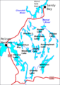
Attitti and surrounding lakes
