Attitti Lake facts for kids
Quick facts for kids Attitti Lake |
|
|---|---|

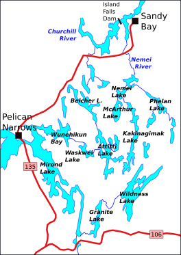
Attitti (center) and surrounding lakes
|
|
| Coordinates | 55°07′N 102°27′W / 55.117°N 102.450°W |
| Type | Lake |
| Basin countries | Canada |
| Surface elevation | 362 metres (1,188 ft) |
Attitti Lake is a beautiful lake found in Saskatchewan, Canada. It is located in a flat, forested area known as the Canadian Shield. The weather here is very cold, like in the subarctic climate zone.
Contents
Where is Attitti Lake?
Attitti Lake is located at about 55 degrees North and 102 degrees West. It sits at an elevation of about 362 metres (1,188 ft) (1,188 feet) above sea level.
Getting There
The lake is northwest of Flin Flon, Manitoba. It is also about 30 miles (48 km) (48 km) east of Pelican Narrows, Saskatchewan. You can reach Attitti Lake by a special winter road. This road connects it to other lakes like Kakinagimak Lake and Wildnest Lake. It also links to Highway 106, which is about 2 miles (3.2 km) (3.2 km) south of Wildnest Lake.
You can also get to Attitti Lake by canoe from Pelican Narrows. This route goes through Wunehikun Bay and Waskwei Lake. Many well-kept portages (places to carry canoes between lakes) connect Attitti Lake to nearby lakes.
What is the Land Like?
The area around Attitti Lake is typical of the Canadian Shield. This means it has a mostly flat surface. There are low hills that usually rise only about 100 to 150 feet (30 to 46 m) (30 to 46 m) above the lakes. The land has long, winding ridges of rock sticking out of the ground. Between these ridges, you'll find wet, spongy areas called muskeg, along with loose soil and lakes.
Water Flow
The water around Attitti Lake flows into different river systems. Some lakes, like Robbestad Lake and the northern part of Kakinagimak Lake, drain north. Their water flows into the Churchill River. Other lakes, like the southern part of Kakinagimak Lake and Wildnest Lake, drain south. Their water goes into the Wildnest-Sturgeon-Weir River System. This system then flows into the Saskatchewan River.
Attitti Lake itself drains eastward. Its water travels through Waskwei Lake and Mirond Lake. Then it joins the Sturgeon-Weir River System, which also flows into the Saskatchewan River System.
Plants and Animals
Attitti Lake is in a subarctic climate zone. This means it has long, cold winters and short, cool summers. The average temperature for the year is about −2 °C (28 °F) (28°F). July is the warmest month, with an average of 16 °C (61 °F) (61°F). January is the coldest, averaging −22 °C (−8 °F) (-8°F).
Forest Life
The lake is surrounded by thick coniferous forest. The main trees you'll see are black spruce, jack pine, and poplar trees. There are also some balsam trees scattered around. These trees usually grow taller than 20 feet (6.1 m) (6 m). In some wet spots, you might find small patches of mossy muskeg. Here, you can see plants like laurel, labrador tea, and some larch trees.
Wildlife and Fishing
Many animals live around Attitti Lake. People hunt animals like moose, woodland caribou, black bear, beaver, otter, and muskrat for food or fur. You might also spot spruce grouse birds.
Attitti Lake is a popular spot for fishing. There's a special lodge on the lake that you can fly into. The lake is home to many fish, including lake trout, northern pike, and walleye.
 | Jackie Robinson |
 | Jack Johnson |
 | Althea Gibson |
 | Arthur Ashe |
 | Muhammad Ali |


