McDuffie County, Georgia facts for kids
Quick facts for kids
McDuffie County
|
|
|---|---|

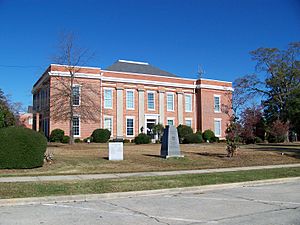
McDuffie County Courthouse in Thomson
|
|

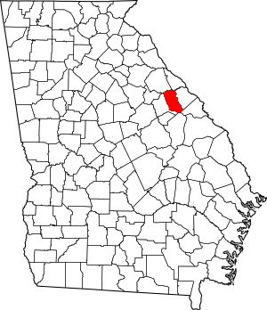
Location within the U.S. state of Georgia
|
|
 Georgia's location within the U.S. |
|
| Country | |
| State | |
| Founded | 1870 |
| Named for | George McDuffie |
| Seat | Thomson |
| Largest city | Thomson |
| Area | |
| • Total | 266 sq mi (690 km2) |
| • Land | 257 sq mi (670 km2) |
| • Water | 8.9 sq mi (23 km2) 3.4%% |
| Population
(2020)
|
|
| • Total | 21,632 |
| • Density | 84/sq mi (32/km2) |
| Time zone | UTC−5 (Eastern) |
| • Summer (DST) | UTC−4 (EDT) |
| Congressional district | 10th |
McDuffie County is a special area called a county in the state of Georgia, USA. It's like a smaller region within the state. In 2020, about 21,632 people lived here.
The main town and government center of the county is Thomson. McDuffie County was officially created on October 18, 1870. It was named after George McDuffie, who was a governor and senator from South Carolina. This county is also part of the larger Augusta-Richmond County area, which includes parts of Georgia and South Carolina.
Contents
Discovering McDuffie County's Past
Many towns and communities in McDuffie County existed even before the county itself was formed. Some of these old settlements have now disappeared. For example, the Historic Wrightsborough Foundation works to remember Wrightborough. This was a large settlement of 12,000 acres that existed from 1768 to 1920.
Geography and Natural Features
McDuffie County covers a total area of about 266 square miles. Most of this area, about 257 square miles, is land. The remaining 8.9 square miles (which is about 3.4%) is water.
The southern part of McDuffie County, especially south of Thomson, is mostly within the Brier Creek area. This area is part of the larger Savannah River basin. A small part of the eastern county, near Dearing, is in the Middle Savannah River area. The northern half of McDuffie County, north of Thomson, is part of the Little River area, which also flows into the Savannah River.
Main Roads in McDuffie County
Many important roads run through McDuffie County, connecting it to other places. These roads help people travel and transport goods.
Neighboring Counties
McDuffie County shares its borders with several other counties in Georgia:
- Lincoln County (to the northeast)
- Columbia County (to the east)
- Richmond County (to the southeast)
- Jefferson County (to the south)
- Warren County (to the west)
- Wilkes County (to the northwest)
Towns and Communities
McDuffie County has a few main towns and several smaller communities.
Cities
- Thomson is the largest city and the county seat. This means it's where the county government is located.
Towns
- Dearing is another town in the county.
Smaller Communities
These are smaller, unincorporated areas that are not officially cities or towns:
- Autney
- Boneville
- Cobbham
- Cobbham Crossroads
Population Over Time
| Historical population | |||
|---|---|---|---|
| Census | Pop. | %± | |
| 1880 | 9,449 | — | |
| 1890 | 8,789 | −7.0% | |
| 1900 | 9,804 | 11.5% | |
| 1910 | 10,325 | 5.3% | |
| 1920 | 11,509 | 11.5% | |
| 1930 | 9,014 | −21.7% | |
| 1940 | 10,878 | 20.7% | |
| 1950 | 11,443 | 5.2% | |
| 1960 | 12,627 | 10.3% | |
| 1970 | 15,276 | 21.0% | |
| 1980 | 18,546 | 21.4% | |
| 1990 | 20,119 | 8.5% | |
| 2000 | 21,231 | 5.5% | |
| 2010 | 21,875 | 3.0% | |
| 2020 | 21,632 | −1.1% | |
| 2023 (est.) | 21,799 | −0.3% | |
| U.S. Decennial Census 1790-1880 1890-1910 1920-1930 1930-1940 1940-1950 1960-1980 1980-2000 2010 |
|||
The population of McDuffie County has changed over many years. In 2020, there were 21,632 people living in the county. These people lived in 8,153 households, and 5,770 of these were families.
| Race | Num. | Perc. |
|---|---|---|
| White (non-Hispanic) | 11,417 | 52.78% |
| Black or African American (non-Hispanic) | 8,644 | 39.96% |
| Native American | 45 | 0.21% |
| Asian | 76 | 0.35% |
| Pacific Islander | 13 | 0.06% |
| Other/Mixed | 647 | 2.99% |
| Hispanic or Latino | 790 | 3.65% |
Education in McDuffie County
For more information about schools and learning in the area, you can check out the section on education in the article about Thomson, Georgia.
See also
 In Spanish: Condado de McDuffie para niños
 | William M. Jackson |
 | Juan E. Gilbert |
 | Neil deGrasse Tyson |

