McLean, Illinois facts for kids
Quick facts for kids
McLean, Illinois
|
|
|---|---|

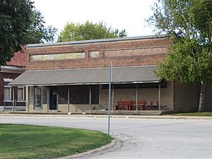
Old building in McLean
|
|

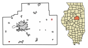
Location in McLean County, Illinois
|
|
| Country | United States |
| State | Illinois |
| County | McLean |
| Township | Mount Hope |
| Area | |
| • Total | 1.18 sq mi (3.05 km2) |
| • Land | 1.18 sq mi (3.05 km2) |
| • Water | 0.00 sq mi (0.00 km2) |
| Elevation | 709 ft (216 m) |
| Population
(2020)
|
|
| • Total | 743 |
| • Density | 631.27/sq mi (243.67/km2) |
| Time zone | UTC-6 (CST) |
| • Summer (DST) | UTC-5 (CDT) |
| ZIP code |
61754
|
| Area code(s) | 309 |
| FIPS code | 17-45811 |
| GNIS ID | 2399296 |
| Wikimedia Commons | McLean, Illinois |
McLean is a small village located in McLean County, Illinois, United States. In 2020, about 743 people lived there. This village is part of the larger Bloomington–Normal area. McLean is also known for being home to the Dixie Travel Plaza.
Contents
Exploring McLean's Location
McLean is found in the southwestern part of McLean County. A major highway, Interstate 55, runs along the east side of the village. You can get to McLean from Exit 145, which connects to U.S. Route 136.
Interstate 55 goes northeast about 15 miles to Bloomington, which is the main city of the county. If you head southwest on I-55, you'll reach Lincoln, about 16 miles away. U.S. Route 136, also called Dixie Road, runs along the southern edge of the village center. It goes east about 10 miles to Heyworth and west about 23 miles to San Jose.
The U.S. Census Bureau says that McLean covers a total area of about 1.18 square miles (3.05 square kilometers), and all of it is land.
McLean's Early Days
How McLean Was Started
The village of McLean was officially planned on June 22, 1855. A man named Franklin Price (1821–1908) created the layout for the town. Price was from Pennsylvania and was related to Kersey Fell, a real estate developer from Bloomington. Franklin Price moved to Bloomington in 1849. He worked as a clerk and wrote for newspapers. He even became the mayor of Bloomington in 1855 and 1856. Interestingly, Price never actually lived in McLean, the town he founded.
McLean was planned when the Alton and Springfield Railroad was being built through McLean County. This railroad later became known as the Alton Railroad. Other nearby towns like Atlanta, Normal, and Towanda were also started around the same time as McLean.
There was an earlier attempt to build a town close by. This town was called Mt. Hope and was started in 1836, two miles east of where McLean is now. It was created by a group from Rhode Island. However, this plan didn't work out very well, and only a few settlers arrived. When McLean was founded, the church building from Mt. Hope was moved to the new village.
The first people to live in McLean were two brothers, G.L. and F.A. Wheelock. They worked for the railroad and moved into the new station house to start their business. The first business in McLean was a blacksmith shop. H.H. Dillon built the first warehouse. McLean officially became a village on May 29, 1866. By the year 1900, its population had grown to 532 people.
The Village's Original Layout
The way McLean was originally designed is still mostly the same today. Its layout was similar to other towns along the Alton and Springfield Railroad, such as Normal and Dwight. The original town was mostly a square, with streets running north-south and east-west. The railroad tracks cut diagonally through the town, with rows of lots (pieces of land) running alongside the tracks.
In McLean, there was a wider rectangular area next to the tracks called "Depot Grounds." This area was only on the southeast side of the railroad. On the northwest side, there was a triangle of land between the lots and the rest of the town. This land was set aside for public use and is still a park today. The design of public land was similar in the village of Towanda.
McLean was unique because it didn't have streets between the diagonal rows of lots along the tracks. Because of this, many businesses grew along Morgan Street, which was just north of the park, or along Hamilton Street, which was just west of the park. The lots next to the tracks on the southeast side became the location for the hotel and the town jail. Later, new areas were added to the east side of town, with more lots along the railroad and regular blocks.
Population Over Time
| Historical population | |||
|---|---|---|---|
| Census | Pop. | %± | |
| 1870 | 600 | — | |
| 1880 | 490 | −18.3% | |
| 1890 | 500 | 2.0% | |
| 1900 | 532 | 6.4% | |
| 1910 | 707 | 32.9% | |
| 1920 | 697 | −1.4% | |
| 1930 | 676 | −3.0% | |
| 1940 | 652 | −3.6% | |
| 1950 | 667 | 2.3% | |
| 1960 | 758 | 13.6% | |
| 1970 | 820 | 8.2% | |
| 1980 | 836 | 2.0% | |
| 1990 | 797 | −4.7% | |
| 2000 | 808 | 1.4% | |
| 2010 | 830 | 2.7% | |
| 2020 | 743 | −10.5% | |
| Decennial US Census | |||
In 2000, there were 808 people living in McLean. There were 314 households and 248 families. The population density was about 1,874 people per square mile.
About 36% of households had children under 18 living with them. Most households (65%) were married couples. Around 9.6% had a female head of household without a husband. About 19.4% of households were individuals living alone.
The average age in the village was 37 years old. About 26.7% of the population was under 18. Around 13.5% were 65 years or older.
The average income for a household in the village was $47,337. For families, the average income was $52,614. Only a small number of families (1.2%) and people (0.7%) lived below the poverty line.
Fun Places to Visit
- Dixie Travel Plaza
- Arcadia: America's Playable Arcade Museum
Schools in McLean
Students in McLean attend schools that are part of the Olympia Community Unit School District 16.
See also
 In Spanish: McLean (Illinois) para niños
 | Sharif Bey |
 | Hale Woodruff |
 | Richmond Barthé |
 | Purvis Young |


