Meall na Teanga facts for kids
Quick facts for kids Meall na Teanga |
|
|---|---|

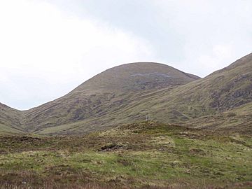
Approaching Meall na Teanga up the path to the Cam Bealach from the Cia-aig waterfall.
|
|
| Highest point | |
| Elevation | 918 m (3,012 ft) |
| Prominence | 303 m (994 ft) |
| Parent peak | Sron a' Choire Ghairbh |
| Listing | Munro, Marilyn |
| Naming | |
| English translation | Hill of the Tongue |
| Language of name | Gaelic |
| Pronunciation | English approximation: MYOWL-nə-TYEN-gə |
| Geography | |
| Location | Highland, Scotland |
| Parent range | Northwest Highlands |
| OS grid | NN220924 |
| Topo map | OS Landranger 34, OS Explorer 400 |
Meall na Teanga is a mountain in Scotland. It is located in the Highland area, about 11 kilometres north of Spean Bridge. This mountain is famous for its beautiful views and is a popular spot for hikers.
Contents
What is Meall na Teanga?
Meall na Teanga is a special kind of Scottish mountain called a Munro. A Munro is a mountain in Scotland that is over 914.4 metres (3,000 feet) tall. Meall na Teanga just makes the cut, standing at 918 metres high!
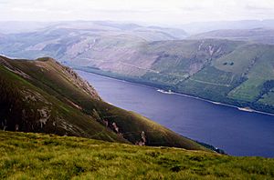
It sits on the northern side of Loch Lochy, a long, narrow lake. You can see Meall na Teanga clearly from the main road, the A82 road, on the other side of the loch. Its slopes look very steep from there.
The name "Meall na Teanga" comes from the Gaelic language. It means "Hill of the Tongue." This name likely refers to one of the mountain's long, tongue-shaped ridges. These ridges either curve around two large hollows or rise steeply from the loch to the top.
Mountain Neighbors
Meall na Teanga is very close to another Munro called Sròn a' Choire Ghairbh. This mountain is only two kilometres away, across a pass known as the Cam Bealach, which means "crooked pass." Because they are so close, people often climb both mountains on the same trip.
How the Mountain Looks
Meall na Teanga has several ridges and three interesting bowl-shaped hollows called corries.
Ridges and Corries
One long ridge stretches for two kilometres to the west. It then drops down grassy slopes towards Gleann Cia-aig. This ridge forms the edge of two big corries that face north: Coire Odhar Mor and Coire Odhar Beag. These corries are steep and rocky. Streams from them form the start of the Abhainn Chia-aig river. This river flows around the mountain and joins the River Arkaig.
There is also a shorter ridge to the north-east. It goes over a smaller peak called Meall Dubh, which is 839 metres high. This ridge then goes down to the Cam Beallach pass, connecting Meall na Teanga to Sròn a' Choire Ghairbh.
Meall na Teanga has three smaller peaks that are part of it, but they are not tall enough to be Munros themselves. Besides Meall Dubh, there is Meall Odhar (872 metres) on the western ridge. There is also Meall Coire Lochain (907 metres), which is near the mountain's third corrie, Coire Lochain. This corrie even has a small loch (lake) inside it!
All the water that flows off Meall na Teanga eventually makes its way to Loch Lochy. From there, it travels to the west coast of Scotland through Loch Linnhe.
Climbing Meall na Teanga
The most common way to climb Meall na Teanga is from the top of the Cam Beallach pass. From this pass, you can also easily climb the nearby Sròn a' Choire Ghairbh.
You can reach the Cam Beallach from the south, starting at the car park near the Cia-aig waterfall. Another popular way to start is from the north-east, near Laggan Locks. A track through the South Laggan Forest leads to the pass from there.
If you want a more exciting climb, you can start from the Cia-aig waterfall and climb the mountain's western ridge. This route lets you see the impressive corries on that ridge up close.
When you reach the top, you'll find a pile of stones called a cairn. From the summit, you get amazing views across the Great Glen. You can see other famous mountains like the Grey Corries, the Aonachs, and even Ben Nevis, the tallest mountain in the UK!
 | Precious Adams |
 | Lauren Anderson |
 | Janet Collins |


