Mermentau, Louisiana facts for kids
Quick facts for kids
Mermentau, Louisiana
|
|
|---|---|
|
Village
|
|
 |
|

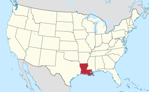
Location of Louisiana in the United States
|
|
| Country | United States |
| State | Louisiana |
| Parish | Acadia |
| Area | |
| • Total | 2.30 sq mi (5.96 km2) |
| • Land | 2.13 sq mi (5.52 km2) |
| • Water | 0.17 sq mi (0.44 km2) |
| Elevation | 7 ft (2 m) |
| Population
(2020)
|
|
| • Total | 516 |
| • Density | 242.03/sq mi (93.47/km2) |
| Time zone | UTC-6 (CST) |
| • Summer (DST) | UTC-5 (CDT) |
| Area code(s) | 337 |
| FIPS code | 22-49870 |
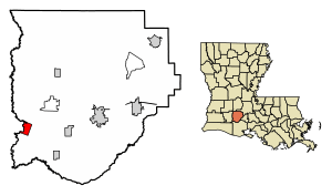
Mermentau is a small village located in Acadia Parish, Louisiana, United States. In 2020, about 516 people lived there. It is part of the Crowley area, which is a group of towns and cities that are close together.
Contents
History of Mermentau Village
How Mermentau Got Its Name
In the late 1700s, there was an Atakapa chief named Nementou. On April 16, 1784, he sold some land near Bayou Plaquemine Brule for $100. Chief Nementou was later known as the leader of a village on a river that had the same name as him. Over time, because of a mistake in writing, "Nementou" became "Mementou." Then, it changed to "Mermentau" because people confused it with the French word mer, which means "sea."
The Mermentau area was once known as a place where people might hide. It was a crossing point for travelers on the Old Spanish Trail. However, it had a reputation for being a wild place. Before the Louisiana Purchase, few people even visited to count how many lived there.
In 1818, a surveyor named John Landreth was sent to find timber for Navy ships. He wrote in his journal that the Mermentau and Calcasieu areas were known for people who were not following the law. These individuals would travel the coast in small boats. They would take things from other boats and sell them cheaply, finding many buyers.
Early Settlers and Growth
During and after the Civil War, there were stories of people hiding in the Mermentau woods. There were also tales of hidden treasures. One story says a man named Frank Quebedeaux found a pot of coins hidden between four copal trees.
One of the first known settlers was John Webb, an English sailor, who arrived in 1827. People say Webb was part of Admiral Horatio Nelson's crew at the famous Battle of Trafalgar in 1805. Nelson was killed in this battle where the British defeated French and Spanish fleets. Webb lived in an area called Webb's Cove, near where the Mermentau River meets Bayou Queue de Tortue. Cornelius Duson McNaughton, who was seeking a new life, joined Webb around 1837.
Jean Castex, from France, came to Mermentau around 1856. He opened a store in 1859 and became a leading merchant in Acadia Parish. He also farmed cotton and rice. In 1860, he built what might have been the first cotton gin in the parish. A sawmill was also built around that time. The Mermentau post office started on September 2, 1859.
Victorin Maignaud, another person from France, arrived in Mermentau in 1866. He opened a dry goods store. Maignaud ran the river ferry for about 40 years and was the postmaster for 17 years. He eventually owned a store, a hotel, a sawmill, and a rice mill.
Timber from the Mermentau area was very important. It provided much of the wood for building homes and fences for settlers on the prairie. This lumber was carried by oxcart to places as far away as Opelousas.
On May 18, 1872, the Opelousas Courier newspaper reported that many carts and wagons loaded with wood were coming from Mermentau. They saw eleven ox-wagons in one day. This shows how much timber was being moved.
Jesuit priests from Grand Coteau started visiting Mermentau in the 1860s. In 1871, Father Joseph Anthonioz began collecting wood to build a chapel, but it was not finished. The first church was built in 1882, but it burned down in 1886.
In 1891, a temporary chapel was built in a different spot. Land for the current church was given in 1889 by Jean Castex and Mrs. Marie U. Duhon. A larger church was built there, but a storm in August 1900 damaged it badly. It was finally rebuilt in 1908.
Connecting by Rail and River
The Louisiana Western Railroad reached Mermentau in 1880. By the end of July that year, the railroad was finished from Mermentau westward to the Texas border. By the end of August 1880, the train line from New Orleans to Houston was open for carrying goods. Passenger trains with sleeping cars began running regularly by the end of September.
Even with trains, moving goods was still a challenge. Products, lumber, and cattle still needed to get to the train line. Captain George W. Caldwell started carrying freight on the Mermentau River around 1890. He eventually owned many small boats and 24 barges. These barges carried rice, oil, cattle, cotton, wood, and other goods. Captain Caldwell also ran a store by the river and used special metal tokens for money, which became known as "Mermentau Money."
In the 1890s, a 96-ton boat called the Olive was popular for carrying passengers and goods on the Mermentau River. It made round trips every other day from Mermentau to Lake Arthur. People from Crowley would take the train to Mermentau, then board the Olive for a weekend trip to Lake Arthur. The boat was known as a "splendid sternwheel packet." The Louisiana Press Association members enjoyed a trip on the Olive in 1894. Tickets were 50 cents one-way or 75 cents for a round trip.
Mermentau officially became a village on November 11, 1899.
Mermentau Today
Today, you can still find arrow points in places where the Atakapa Indians once lived. Mermentau is also known for a legend that Captain James Campbell, a trusted helper of the pirate Jean Laffite, hid $9,000 in gold coins there.
Geography and Environment
Mermentau is located at 30°11′16″N 92°34′58″W / 30.18778°N 92.58278°W.
According to the United States Census Bureau, the village covers a total area of about 2.30 square miles (5.96 square kilometers). Most of this area, about 2.13 square miles (5.52 square kilometers), is land. The rest, about 0.17 square miles (0.44 square kilometers), is water.
Mermentau is located along the Mermentau River. This river provides fresh water to the Mermentau Basin. This basin includes about 450,000 acres (1,821 square kilometers) of wetlands. These wetlands are made up of different types of marsh:
- 190,000 acres (769 square kilometers) of fresh marsh
- 135,000 acres (546 square kilometers) of intermediate marsh
- 101,000 acres (409 square kilometers) of brackish marsh (a mix of fresh and salt water)
Since 1932, about 104,380 acres (422 square kilometers) of marsh in the basin have turned into open water. This means about 19 percent of the historical wetlands have been lost.
Population Information
| Historical population | |||
|---|---|---|---|
| Census | Pop. | %± | |
| 1910 | 323 | — | |
| 1920 | 364 | 12.7% | |
| 1930 | 394 | 8.2% | |
| 1940 | 571 | 44.9% | |
| 1950 | 636 | 11.4% | |
| 1960 | 334 | −47.5% | |
| 1970 | 716 | 114.4% | |
| 1980 | 771 | 7.7% | |
| 1990 | 760 | −1.4% | |
| 2000 | 721 | −5.1% | |
| 2010 | 661 | −8.3% | |
| 2020 | 516 | −21.9% | |
| U.S. Decennial Census | |||
In the year 2000, there were 721 people living in Mermentau. There were 277 households and 204 families. The population density was about 337.9 people per square mile (130.5 people per square kilometer). There were 344 housing units, with an average of 161.2 units per square mile (62.2 units per square kilometer).
The people living in the village were mostly White (85.99%) and African American (12.48%). A small number were Native American (0.42%) or from other races (0.42%). About 0.69% of people were from two or more races. About 2.08% of the population was Hispanic or Latino.
Out of 277 households, 34.3% had children under 18 living with them. About 50.5% were married couples living together. About 16.2% had a female head of household with no husband present. About 26.0% were not families. Around 21.7% of all households were made up of individuals. About 11.2% had someone living alone who was 65 years old or older. The average household size was 2.60 people, and the average family size was 3.02 people.
The population was spread out by age:
- 28.8% were under 18 years old.
- 7.6% were from 18 to 24 years old.
- 27.7% were from 25 to 44 years old.
- 24.0% were from 45 to 64 years old.
- 11.8% were 65 years or older.
The average age in the village was 35 years. For every 100 females, there were about 93.3 males. For every 100 females aged 18 and over, there were about 95.1 males.
The average income for a household in the village was $26,786. For a family, the average income was $31,250. Males had an average income of $32,917, while females had an average income of $13,977. The per capita income for the village was $11,408. About 25.0% of families and 26.4% of the total population lived below the poverty line. This included 31.3% of those under 18 and 39.3% of those aged 65 or older.
Education
The Acadia Parish School Board provides education services for the children in Mermentau.
See also
 In Spanish: Mermentau para niños
 | Frances Mary Albrier |
 | Whitney Young |
 | Muhammad Ali |

