Mialoquo (Cherokee town) facts for kids
Quick facts for kids |
|
|
Mialoquo
|
|

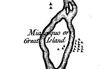
Mialoquo on Henry Timberlake's 1762 "Draught of the Cherokee Country"
|
|
| Location | Monroe County, Tennessee |
|---|---|
| Nearest city | Vonore |
| Built | c. 1760 A.D. |
| NRHP reference No. | 78002616 |
| Added to NRHP | 1978 |
Mialoquo (also called "Malaquo", "Big Island", or "Great Island") was an important ancient Native American site. It was located in Monroe County, Tennessee, in the southeastern United States. This area was home to people during the Mississippian period (around 1000-1600 AD). Later, it became a village for Cherokee people seeking safety.
The main Mialoquo site (Cherokee: ᎠᎹᏰᎴᏆ, romanized: Amayelequa) was on the southwest bank of the Little Tennessee River. However, the village likely also included part of Rose Island. This was a large island in the river right across from the main site. Rose Island was used by people as early as the Middle Archaic period.
Today, both the Mialoquo site and Rose Island are underwater. They were covered when Tellico Lake was created by building a dam on the Little Tennessee River. The area is now managed by the Tennessee Valley Authority and the Tennessee Wildlife Resources Agency. You can still see where these sites were by looking north from the U.S. Route 411 bridge in Vonore. You can also see them by looking west from Wildcat Point, a cliff on the river's eastern bank.
Contents
Where Was Mialoquo Located?
The Little Tennessee River flows into Tennessee from between the Great Smoky Mountains and the Unicoi Mountains. It travels about 50 miles (80 km) before joining the Tennessee River. Tellico Lake, which was formed in 1979, covers the lower 33 miles (53 km) of the river.
Before the lake was made, the Mialoquo site was located where Island Creek met the river. This was about 17 miles (27 km) upstream from the river's mouth. Rose Island stretched across the river between 16.8 miles (27 km) and 18.4 miles (29.6 km) from the river's mouth. Both sites were just south of a bend in the river called Wears Bend. They were also just north of where the Tellico River joins the Little Tennessee River.
Wildcat Point is a cliff that looks over the now-underwater Rose Island and Mialoquo sites. A hiking trail connects it to Tellico Parkway during certain seasons. The hills around the river are part of the Appalachian Ridge-and-Valley Physiographic Province.
History of the Great Island Village
The name "Mialoquo" comes from the Cherokee word for "Great Island." This name makes sense because the village was on and next to what is now called Rose Island. This island was the largest in the Little Tennessee River before Tellico Lake was created.
Mialoquo first appeared in historical records in 1761. It was shown on Henry Timberlake's map called "Draught of the Cherokee Country." Timberlake visited the Overhill settlements to make peace. He reported that Mialoquo had 18 houses, both on the mainland and on Rose Island. However, he didn't mention a townhouse. A Cherokee village was not considered a "town" without a townhouse. This might be why Mialoquo appeared in records later than other towns.
Timberlake also reported that 24 Overhill Cherokee warriors lived at Mialoquo. They were led by Attakullakulla, who was the chief of the nearby village of Tuskegee at the time.
Some historians believe Mialoquo was formed by Cherokee people who had to leave their homes. These people were fleeing from Colonial forces who destroyed their Lower and Middle towns in 1761. John Norton wrote that after James Grant destroyed the Cherokee town of Kittowa, the survivors went to "Big Island." Mialoquo was not on a 1757 map of the Overhill towns, but it was on Timberlake's 1761 map. This suggests the town was settled between those years.
During the American Revolutionary War, Dragging Canoe became the chief at Mialoquo. In 1776, the Cherokee sided with the British. Because of this, the colonies sent Colonel William Christian to stop the fighting in the Overhill towns. Christian arrived without a fight and set up his base at Mialoquo. There, he held peace talks with Cherokee leaders Attakullakulla and Oconastota. However, Dragging Canoe refused to talk. So, Christian destroyed Mialoquo and four other Overhill towns.
What Archaeologists Found
Archaeologists study the past by digging up and examining old objects and structures. Cyrus Thomas, working for the Smithsonian Institution, surveyed mounds in the Little Tennessee Valley in the 1880s. He believed he had found Mialoquo.
When the building of Tellico Dam was announced in 1967, the University of Tennessee began rescue excavations. They dug at both Rose Island (called 40MR44 by archaeologists) and Mialoquo (called 40MR3).
Discoveries on Rose Island
Rose Island was used by hunter-gatherers as early as 6000 BC, and possibly even 7500 BC. These early people likely used the chert (a type of rock) found in the nearby hills. Rose Island was also heavily used between about 350 BC and 100 AD, during the Woodland period.
Archaeologists found many artifacts from the Archaic period on Rose Island. These included pointed tools, wedges, and various ground stone objects. From the Woodland period, they found more pointed tools, scrapers, axes, and even a bird-shaped carving. Several burials from the Woodland period were also found on Rose Island.
Discoveries at Mialoquo
The Mialoquo site was probably used during the Archaic period, but we don't know how much. Of the 60 features found at the site, 8 were from the Mississippian period. These were mostly pits where trash was thrown. The rest of the features were from the Cherokee period. The way the features were spread out suggests people lived there for a short time.
Archaeologists found over 6,000 pieces of pottery at Mialoquo. About 13.5% of these were "Qualla pottery." This type of pottery is linked to the Cherokee Middle towns in North Carolina. This finding supports the idea that people from those towns came to live at Mialoquo in the 1760s. The pottery found here was similar to pottery from nearby Tomotley, which was also thought to be a "refugee town."
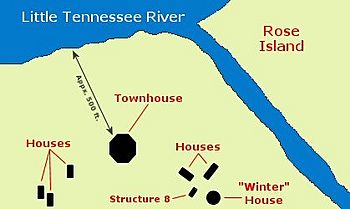
The structures found at Mialoquo included the outlines of a townhouse and 6 homes. There was also one smaller rectangular building whose purpose is unknown. The homes included a circular winter house and a rectangular summer house, which was common for Overhill Cherokee homes. The townhouse was octagonal (eight-sided) and measured between 52 feet (16 m) and 60 feet (18 m) across.
The rectangular homes were between 22 feet (6.7 m) and 32 feet (9.8 m) long, and 12 feet (3.7 m) to 14 feet (4.3 m) wide. The circular "winter house" was 23.5 feet (7.2 m) across. The unknown rectangular building was 15 feet (4.6 m) by 9.6 feet (2.9 m).
Almost 5,000 stone artifacts were found at Mialoquo. These included pointed tools, scrapers, drills, and a stone pipe. Archaeologists also found European items. These included tobacco pipes, gun parts, ammunition, glass beads, and two Jew's harps (a musical instrument).
 | Misty Copeland |
 | Raven Wilkinson |
 | Debra Austin |
 | Aesha Ash |


