
Middleburg, Florida facts for kids
Quick facts for kids
Middleburg, Florida
|
|
|---|---|

Top, left to right: Black Creek, Middleburg United Methodist Church, Middleburg High School, Jennings State Forest
|
|

Location in Clay County and the state of Florida
|
|
| Country | |
| State | |
| County | Clay |
| Area | |
| • Total | 19.62 sq mi (50.81 km2) |
| • Land | 19.62 sq mi (50.81 km2) |
| • Water | 0.00 sq mi (0.00 km2) |
| Elevation | 33 ft (10 m) |
| Population
(2020)
|
|
| • Total | 12,881 |
| • Density | 656.66/sq mi (253.53/km2) |
| Time zone | UTC−5 (Eastern (EST)) |
| • Summer (DST) | UTC−4 (EDT) |
| ZIP Codes |
32050, 32068
|
| Area code(s) | 904 |
| FIPS code | 12-45350 |
| GNIS feature ID | 0286819 |
Middleburg is a community in Clay County, Florida, in the United States. It's not officially a city, but a "census-designated place" (CDP). This means it's an area that the government counts as a separate place for population statistics.
Middleburg is about 26 miles southwest of Jacksonville. It's also 16 miles northwest of Green Cove Springs, which is the main town of Clay County. In 2020, about 12,881 people lived in Middleburg. It's part of the larger Jacksonville area.
The community is home to Middleburg High School. It also has the Middleburg Historic District, which is a special area with old buildings.
Contents
Exploring Middleburg's Location
Middleburg is located in the northwest part of Clay County. You can find it at these coordinates: 30.050783 degrees North, -81.902013 degrees West.
Florida State Road Blanding Boulevard is a main road here. It goes northeast for about 13 miles to the Orange Park area. If you go southwest on it, you'll reach Keystone Heights in about 23 miles.
The United States Census Bureau says that Middleburg covers a total area of about 19.6 square miles (50.7 square kilometers). All of this area is land.
Middleburg's Population Over Time
| Historical population | |||
|---|---|---|---|
| Census | Pop. | %± | |
| 1990 | 6,223 | — | |
| 2000 | 10,338 | 66.1% | |
| 2010 | 13,008 | 25.8% | |
| 2020 | 12,881 | −1.0% | |
| U.S. Decennial Census | |||
In 2010, there were 13,008 people living in Middleburg. They lived in 4,891 homes. The population grew quite a bit between 2000 and 2010.
Most people in Middleburg are White (92.9%). There are also African American (3.1%), Native American (0.6%), and Asian (0.7%) residents. About 4.1% of the population is Hispanic or Latino.
Looking at age groups, about 24.87% of the people were under 18 years old. About 10.36% were 65 years or older. The population is almost evenly split between females (49.7%) and males (50.3%).
Middleburg's Interesting Past
Middleburg has a long history, starting almost 200 years ago. It has changed names and played important roles in Florida's past.
Early Days and Name Changes
The area was first settled as a village in the early 1800s. Asa Clark ran the first ferry across Black Creek until 1828. Because of this, the settlement was first called Clark's Ferry.
A road called the Federal Military Road was built between 1824 and 1827. This road went through Clark's Ferry, which helped the community grow. It also became a postal route.
There was another settlement nearby called Whitesville. It was big enough to have its own post office in 1828. Around the same time, Isaac Boring started the Black Creek Methodist Church.
In 1828, John Hanson took over Clark's ferry. Later, in 1833, Samuel and Charlotte Garey bought it. This led to the area being known as Garey's Ferry.
Forts and Protection
The community grew a lot during the Second Seminole War. This was a conflict between the United States and the Seminole people.
Fort Heileman
In 1836, a wooden fort called Fort Heileman was quickly built. It was located near Black Creek. This fort protected settlers at Garey's Ferry. It was also a main storage and supply place for the army in eastern Florida.
Fort Heileman was used until 1841, when its weapons were moved. It was completely abandoned in 1842 and then destroyed by a flood. The only building that might be left from that time is the Clark-Chalker House. It was built in 1835 and might have been the fort's hospital.
Fort Sanderson
Another fort, Fort Sanderson, was built around 1840 in Garey's Ferry. Its exact location is unknown. It was mainly used for storage and was abandoned the next year.
Becoming Middleburgh and a County Seat
After the Seminole Wars, Garey's Ferry continued to grow. People traded timber, citrus fruits, cotton, and farm crops. In 1851, Garey's Ferry and Whitesville joined together. They formed a new town called Middleburgh. The post office moved to its current spot on Palmetto Street.
In December 1858, Clay County was created from Duval County. It was named after Henry Clay. Middleburgh became the main town, or "county seat," of Clay County. It remained the county seat until 1874.
Before the American Civil War, Middleburgh and Clay County supported the Whig Party. They also supported staying united with the rest of the country. In 1859, Whitesville residents even renamed their community Webster. This was to honor the Whig politician Daniel Webster.
Middleburg During the Civil War
During the American Civil War, Middleburg saw some fighting. On October 23, 1864, soldiers from the 4th Massachusetts Volunteer Cavalry fought local Confederate soldiers.
The next day, October 24, 1864, the Massachusetts soldiers raided downtown Middleburg. They set fire to buildings on Main Street and Thompson (now Wharf) Street. They destroyed warehouses, docks, and a hotel.
Confederate soldiers, led by Captain J.J. Dickison, fought back. The Massachusetts regiment retreated across Black Creek and burned the ferry bridge. Dickison's soldiers chased them and fought them again at Jeremiah Halsey's Plantation. This fight is known as the Battle of Halsey's Plantation. It resulted in a Confederate victory. The exact location of Halsey's Plantation is not known, but it was near Shadowlawn Elementary School.
There was another skirmish where Dickison's troops rescued cattle taken by Union soldiers. Local stories call this the Battle of the Tiger Head.

Changes and Growth
Middleburg struggled after the Civil War. Its population dropped to less than 100 residents. Between 1890 and 1920, it had about 700 people. A very cold winter in 1895, called the Great Freeze, also hurt the town. River trade also decreased, which added to its decline.
In the 1890s, African American families started settling in the Hill Top community. Grant Forman was one of the first in 1895. He developed the area known as Forman Circle.
The 1989 movie Brenda Starr had some scenes filmed on Black Creek.
Since the 1990s, Middleburg has grown a lot. Its population and businesses have expanded. This growth is happening along with nearby communities like Orange Park, Lakeside, Lake Asbury, and Fleming Island.
Because of this growth, a new highway called the First Coast Expressway is being built. It will go through Middleburg and add new exit ramps.
Famous People from Middleburg
Many interesting people have connections to Middleburg:
- Gary Barnidge, a professional football player (tight end)
- Lenny Curry, the mayor of Jacksonville, Florida
- Roy Geiger, a US Marine Corps general during World War II
- Ashley Greene, an actress
- Richard Owens, a professional football player (tight end)
- Donnie Van Zant, a musician from the bands 38 Special and Van Zant
- Johnny Van Zant, a musician from the bands Lynyrd Skynyrd and Van Zant
- Slim Whitman, a country music singer and songwriter
Bands
- The Red Jumpsuit Apparatus, a rock band
Images for kids
-
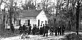
Methodist Church in the 1880s
See also
 In Spanish: Middleburg (Florida) para niños
