
Middletown, Dauphin County, Pennsylvania facts for kids
Quick facts for kids
Middletown, Pennsylvania
|
||
|---|---|---|
|
Borough
|
||

Union Street in Middletown
|
||
|
||

Location of Dauphin County in Pennsylvania (left) and of Middletown in Dauphin County (right)
|
||

Middletown, Dauphin County, Pennsylvania
Location in Pennsylvania

Middletown, Dauphin County, Pennsylvania
Location in the United States
|
||
| Country | United States | |
| State | Pennsylvania | |
| County | Dauphin | |
| Settled | 1755 | |
| Incorporated | 1828 | |
| Government | ||
| • Type | Borough Council | |
| Area | ||
| • Total | 2.08 sq mi (5.40 km2) | |
| • Land | 2.03 sq mi (5.26 km2) | |
| • Water | 0.06 sq mi (0.14 km2) | |
| Elevation | 360 ft (110 m) | |
| Population
(2020)
|
||
| • Total | 9,533 | |
| • Density | 4,696.06/sq mi (1,812.72/km2) | |
| Time zone | UTC-5 (Eastern (EST)) | |
| • Summer (DST) | UTC-4 (EDT) | |
| ZIP Code |
17057
|
|
| Area code(s) | 717 | |
| FIPS code | 42-49128 | |
| GNIS feature ID | 1215165 | |
|
Pennsylvania Historical Marker
|
||
| Designated: | April 17, 1952 | |

Middletown is a small town, called a borough, in Dauphin County, Pennsylvania. It sits right on the Susquehanna River, about 10 miles (16 km) southeast of Harrisburg. In 2020, about 9,550 people lived there. Middletown is part of the larger Harrisburg–Carlisle area.
Contents
History of Middletown
Early Beginnings: 18th Century
Middletown was started in 1755 along the Susquehanna River. It became an official borough in 1828. This happened after a big growth spurt! A new waterway, the Union Canal, was built, connecting Lancaster to Middletown.
In 1824, Pennsylvania's government decided to build this canal. It was part of a huge plan called the Main Line of Public Works. This project aimed to link Philadelphia to Pittsburgh using canals and rivers. The goal was to help Philadelphia compete with New York City and its Erie Canal for trade.
Middletown was chosen as the western end of the Union Canal. It got its name because it was halfway between Lancaster and Carlisle. It's the oldest town in Dauphin County and is in a rich farming area.
Growth and Change: 19th Century
A trust called the George Everhart (Frey) Trust still manages much of the land in Middletown. This trust was set up by a Middletown citizen from the 1800s. It used to run the Frey Orphanage for many years.
The orphanage eventually closed. Its last location is now the Frey Village Retirement Community. This is a place where older adults can live and be cared for.
Modern Times: 20th Century Events
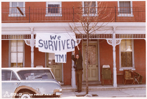
Middletown is only about 3 miles (5 km) north of the Three Mile Island Nuclear Power Plant. In 1979, one of the reactors at Three Mile Island had a partial meltdown. This means it got too hot and some parts melted.
Because of this, the governor of Pennsylvania, Dick Thornburgh, asked pregnant women and young children to leave the area. Within a few days, 140,000 people had left. President Jimmy Carter even visited Middletown to help calm everyone's worries.
Middletown is an old town, so you can see many different styles of buildings. There are old log houses and fancy Victorian mansions. Some historic buildings are listed on the National Register of Historic Places. These include the Simon Cameron House and Bank and the B'nai Jacob Synagogue.
Middletown's Location and Landscape
Middletown is in the southern part of Dauphin County. Its southern edge is along the Susquehanna River. The Swatara Creek forms its eastern border, with the town of Royalton on the other side.
Pennsylvania Route 230 (Main Street) goes northwest 10 miles (16 km) to Harrisburg. It goes southeast 8 miles (13 km) to Elizabethtown. If you take the PA 283 expressway, it's 28 miles (45 km) southeast to Lancaster. The Pennsylvania Turnpike (Interstate 76) runs through the northern part of Middletown.
The U.S. Census Bureau says that Middletown covers about 2.08 square miles (5.4 square kilometers). Most of this area is land, with a small part being water.
Middletown's Population
| Historical population | |||
|---|---|---|---|
| Census | Pop. | %± | |
| 1820 | 567 | — | |
| 1830 | 302 | −46.7% | |
| 1850 | 900 | — | |
| 1860 | 2,392 | 165.8% | |
| 1870 | 2,980 | 24.6% | |
| 1880 | 3,351 | 12.4% | |
| 1890 | 5,080 | 51.6% | |
| 1900 | 5,608 | 10.4% | |
| 1910 | 5,374 | −4.2% | |
| 1920 | 5,920 | 10.2% | |
| 1930 | 6,085 | 2.8% | |
| 1940 | 7,046 | 15.8% | |
| 1950 | 9,184 | 30.3% | |
| 1960 | 11,182 | 21.8% | |
| 1970 | 9,080 | −18.8% | |
| 1980 | 10,122 | 11.5% | |
| 1990 | 9,254 | −8.6% | |
| 2000 | 9,242 | −0.1% | |
| 2010 | 8,901 | −3.7% | |
| 2020 | 9,550 | 7.3% | |
| 2021 (est.) | 9,587 | 7.7% | |
| Sources: | |||
In 2000, there were 9,242 people living in Middletown. There were about 4,032 households, which are groups of people living together.
Most people in Middletown are White (88.77%). About 7.34% are African American. A small number of people are Native American, Asian, or Pacific Islander. About 3.18% of the population is Hispanic or Latino.
About 28.2% of households had children under 18 living with them. Many households (40.8%) were married couples. About 14.2% of households had someone living alone who was 65 or older. The average household had 2.23 people.
The median age in the borough was 37 years old. This means half the people were younger than 37, and half were older.
Education in Middletown
Middletown has several places for learning:
- Middletown Area School District
- Penn State Harrisburg
Arts and Culture in Middletown
Local Businesses and Events
- The Performo Toy Company is located here.
- The Middletown Area Historical Society holds an Annual Arts and Craft Fair. It happens in Hoffer Park on the first Saturday in June.
- Trick or Treat night is usually the Thursday closest to (before) Halloween. If a house has its porchlight on from 6 pm to 8 pm, it means they are participating.
Museums and Interesting Places
The Middletown Area Historical Society is a museum and visitor center. You can find it at 29 East Main Street.
Indian Echo Caverns is a cool place to visit about 5 miles (8 km) north of Middletown. These caves were once used by the Susquehannock tribe. They lived and hunted in the area a long time ago. The caverns opened to the public in 1929.
You can also ride on the Middletown and Hummelstown Railroad. This shortline train offers rides and carries freight between Middletown and Hummelstown. It even stops near the Indian Echo Caverns entrance!
Around Town
In Middletown, you'll find an American Legion building, a borough office building, and a post office. The American Legion is at High and Spruce Streets. The post office is on Main Street, and the borough office is on West Emaus Street. There are also several churches in town.
The Middletown Volunteer Fire Department sometimes helps give out Potassium Iodide pills. These pills are supplied by the Pennsylvania Department of Health. This is because Middletown is within 10 miles (16 km) of the Three Mile Island power plant.
See also
 In Spanish: Middletown (condado de Dauphin, Pensilvania) para niños
