
Mike O'Callaghan–Pat Tillman Memorial Bridge facts for kids
Quick facts for kids Mike O'Callaghan–Pat Tillman Memorial Bridge |
|
|---|---|

The bridge in front of the Hoover Dam
|
|
| Coordinates | 36°0′45″N 114°44′29″W / 36.01250°N 114.74139°W |
| Carries | Four lanes of |
| Crosses | Colorado River |
| Locale | Lake Mead National Recreation Area, Clark County, Nevada – Mohave County, Arizona |
| Official name | Mike O'Callaghan–Pat Tillman Memorial Bridge |
| Other name(s) | Hoover Dam Bypass Bridge |
| Maintained by | Arizona Department of Transportation (ADOT) Nevada Department of Transportation (NDOT) |
| Characteristics | |
| Design | concrete-steel composite arch bridge |
| Total length | 1,900 feet (579 m) |
| Longest span | 1,060 ft (323 m) |
| Clearance below | 890 ft (270 m) |
| History | |
| Designer | Bridge Designer T.Y. Lin International Design Manager HDR, Inc. |
| Construction begin | February 14, 2005 |
| Construction end | October 14, 2010 |
| Construction cost | $240 million |
| Opened | October 16, 2010 (to pedestrians); October 19, 2010 (regular traffic) |
| Statistics | |
| Daily traffic | 15,000 |

The Mike O'Callaghan–Pat Tillman Memorial Bridge is a special kind of bridge called an arch bridge. It connects the states of Arizona and Nevada by crossing the Colorado River. This amazing bridge is found in the Lake Mead National Recreation Area, about 30 miles (48 km) southeast of Las Vegas. It carries two major highways, Interstate 11 and U.S. Route 93, over the river.
Opened in 2010, this bridge was a very important part of the Hoover Dam Bypass project. Before the bridge, US 93 went right over the top of the famous Hoover Dam. This old route had many sharp turns and blind spots, which made it dangerous. The new bridge helped make travel much safer and smoother.
The bridge is named after two important people: Mike O'Callaghan and Pat Tillman. Mike O'Callaghan was the Governor of Nevada from 1971 to 1979. Pat Tillman was a talented American football player for the Arizona Cardinals. He bravely left his sports career to join the United States Army and sadly died while serving in Afghanistan in 2004.
Even in the 1960s, people knew that the US 93 route over Hoover Dam was not safe enough for the growing amount of traffic. From 1998 to 2001, officials from Arizona, Nevada, and the government worked together. They wanted to find the best way to build a new river crossing. In March 2001, they chose a route that would cross the Colorado River about 1,500 feet (460 m) downstream from Hoover Dam.
Building the roads leading to the bridge started in 2003. The bridge itself began construction in February 2005. The bridge was finished in 2010, and the entire new highway route opened to cars on October 19, 2010. The whole Hoover Dam Bypass project cost $240 million, and the bridge part cost $114 million.
This bridge was the first of its kind in the United States. It is a concrete-steel composite arch bridge. It also has the widest concrete arch in the Western Hemisphere. At 890 feet (270 m) above the Colorado River, it is the second highest bridge in the United States. Only the Royal Gorge Bridge in Colorado is taller. It is also the world's highest concrete arch bridge.
Contents
Why the Bridge Was Needed
Traffic and Safety Concerns
In 1935, a highway called U.S. Route 93 was extended to cross the Colorado River over the newly built Hoover Dam. At that time, the area around Clark County was not very populated. But over the years, Las Vegas grew into a huge tourist attraction. This made US 93 a very important road for both cars and trucks traveling between Las Vegas and Phoenix.
More and more cars and tourists visiting Hoover Dam caused big traffic jams on the dam itself. The roads leading to the dam had very sharp turns and places where drivers couldn't see well. This created safety problems. Officials were also worried about the safety of Hoover Dam. They feared a car accident could harm the dam or the water in Lake Mead.
People first talked about needing a new river crossing to bypass the dam in the 1960s. The United States Bureau of Reclamation, which runs the dam, started a project in 1989. But this project was stopped in 1995. Then, in 1997, the Federal Highway Administration took over. They looked at different routes and ways to cross the river.
Choosing the Best Route
In March 2001, the Federal Highway Administration decided on the "Sugarloaf Mountain Alternative" route. This plan included about 2.2 miles (3.5 km) of highway in Nevada and 1.1 miles (1.8 km) in Arizona. The bridge itself would be 1,900 feet (580 m) long. It would cross the river about 1,500 feet (460 m) south of Hoover Dam. The design work for the bridge began in July 2001.
After the September 11 attacks, large trucks were not allowed to drive across Hoover Dam for security reasons. Before the new bridge opened, commercial trucks had to take a long detour. This detour was 104 miles (167 km) long. It added about 23 miles (37 km) to their trip. The new bridge solved this problem.
How the Bridge Was Designed

The design of the bridge was handled by a team called the Hoover Support team. This team included several engineering companies.
The bridge is 1,900 feet (579 m) long, with a main arch span of 1,060 ft (320 m). The road is about 900 ft (270 m) above the Colorado River and has four lanes for traffic. This bridge is special because it's the first concrete-and-steel composite arch bridge built in the United States. It also has the widest concrete arch in the Western Hemisphere. The arch itself is 840 ft (260 m) above the river. The two arch ribs are connected by strong steel supports.
Designers chose to use both concrete for the arch and columns, and steel for the road deck. This mix of materials helped keep the project on schedule and within budget. It also made the bridge look good next to the Hoover Dam. Many people have praised the bridge's design. USA Today even called it "America's Newest Wonder" when it opened.
There is a special walkway on the bridge for people who want to walk or bike. From here, you can get a great view of the nearby dam and the river below. However, drivers crossing the bridge cannot see the dam. There's a parking area on the Nevada side where you can leave your car. From there, stairs and ramps lead to the sidewalk on the bridge.
Building the Bridge

Work on the roads leading to the bridge started in 2003. The contract to build the arch bridge was given out in October 2004. The biggest challenge was crossing the river itself. Many different government agencies and construction companies worked together on this huge project.
One problem that caused a four-month delay happened in May 2006. It was about getting concrete for the project. Later, in September 2006, strong winds caused a special crane system to break. This crane was used to lift workers and materials high above the river. This accident caused another two-year delay in building the bridge.

The parts of the bridge leading up to the main arch were finished in March 2008. These parts have seven pairs of concrete columns. Five are on the Nevada side and two are on the Arizona side. Sadly, in November 2008, a construction worker named Sherman Jones died in an accident.
The main arches of the bridge are made of 106 pieces, 53 for each arch. Most of these pieces were cast (poured) in place. The arches were built from both sides of the river at the same time. They were held up by strong diagonal cables attached to temporary towers. The two halves of the arch were completed in August 2009. They were only 3⁄8 inch (9.5 mm) apart. This small gap was filled with a block of reinforced concrete. After that, the temporary cables were removed, and the arch could stand on its own.

By December 2009, all eight vertical supports on the arch were in place. Soon after, the first of 36 large steel beams were set. By mid-April 2010, all the beams were in place. For the first time, construction workers could walk across the structure from Arizona to Nevada. Then, they started pouring the concrete for the bridge deck.

The bridge deck was fully paved in July 2010. The large cranes were then removed as the project was almost done. The bridge was officially opened with a ceremony on October 14, 2010. A big opening party was held on October 16. It opened to people walking and biking on October 18. Finally, it opened to cars on October 19, a few weeks earlier than expected. The building of this bridge was even shown on a TV show called Extreme Engineering.
When the bridge opened, the road over Hoover Dam was closed to regular traffic. Now, all visitors to the dam go through the Nevada side. Cars can still drive across the dam to the Arizona side after a security check. But they must return to the Nevada side to get back on US 93. The highway using the new bridge was also given the name Interstate 11 in 2018.
Naming the Bridge
In late 2004, the plan to name the bridge after Mike O'Callaghan and Pat Tillman was announced. This happened at a ceremony with the Governor of Nevada, Kenny Guinn, and the Governor of Arizona, Janet Napolitano.
- Mike O'Callaghan was a brave veteran of the Korean War. He served as the Governor of Nevada from 1971 to 1979. He was also a newspaper editor for many years until he passed away in 2004.
- Pat Tillman was a football player for Arizona State University and the Arizona Cardinals. He gave up his very successful career in the National Football League to join the United States Army. Sadly, he died while serving in Afghanistan in 2004.
Images for kids
-
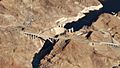
The Mike O'Callaghan–Pat Tillman Memorial Bridge in front of the Hoover Dam.
-
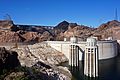
View from upstream of Hoover Dam with Mike O'Callaghan–Pat Tillman Memorial Bridge in background
-
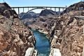
View from Hoover Dam
.jpg)


See also
 In Spanish: Puente Mike O%27Callaghan–Pat Tillman para niños
