
Milford, Texas facts for kids
Quick facts for kids
Milford, Texas
|
|
|---|---|
.jpg)
Downtown Milford in 2010
|
|
| Motto(s):
"Small town living with room to grow"
|
|

Location of Milford, Texas
|
|
 |
|
| Country | United States |
| State | Texas |
| County | Ellis |
| Area | |
| • Total | 2.47 sq mi (6.39 km2) |
| • Land | 2.46 sq mi (6.37 km2) |
| • Water | 0.01 sq mi (0.02 km2) |
| Elevation | 637 ft (194 m) |
| Population
(2020)
|
|
| • Total | 722 |
| • Density | 303.54/sq mi (117.18/km2) |
| Time zone | UTC-6 (Central (CST)) |
| • Summer (DST) | UTC-5 (CDT) |
| ZIP code |
76670
|
| Area code(s) | 214, 469, 945, 972 |
| FIPS code | 48-48408 |
| GNIS feature ID | 2412995 |
Milford is a small town in North Central Texas. It is located in the southwestern part of Ellis County, in the United States. In 2020, about 722 people lived there.
Milford is about 14 miles northeast of Hillsboro. It is also about 20 miles southwest of Waxahachie. In 2013, the town was in the news because of a gas pipeline incident. This event led to the town being evacuated for safety.
Contents
History of Milford
How Milford Started
Milford's story began in the 1850s. Some people from Cherokee County came to the Mill Creek valley. They bought land for a very low price. William R. Hudson named the town Milford. He named it after a factory town in Milford, Massachusetts.
In 1853, the first house was built. It was also a general store and belonged to William R. Hudson. A two-story schoolhouse was also built. This school served as a church and community hall. Sadly, it burned down during the Civil War.
In 1854, Arvin Wright, William Hudson, and J.M. Higgins planned out the town. They set up town lots on a ridge. A gristmill started working in 1857. Milford officially became a town in 1888. W.R. McDaniel was the first mayor.
Growth and Changes
By 1890, train tracks reached Milford. The Dallas and Waco Railway came through town. This made Milford an important place for shipping cotton. Farmers could send their crops from here.
By 1892, Milford had grown quite a bit. About 800 people lived there. The town had three churches, a bank, and a hotel. There were also two cotton gins and many other businesses. A weekly newspaper was also printed.
Milford had two schools at this time. One was a private school called Lone Star Institute. The other was Milford Academy, which the community helped pay for. In 1902, the town offered to open the Texas Presbyterian College for Girls. This college opened in Milford.
The town kept growing, and by 1929, about 1,200 people lived there. However, the Great Depression caused the population to drop. The Presbyterian college also closed. By 1931, Milford's population was 747. It kept going down, reaching a low of 490 in 1968. But the town grew again. By 1990, the population was back up to 711.
Gas Pipeline Incident in 2013
On November 14, 2013, a gas pipeline incident happened. It was near U.S. 77 and FM 308. A gas pipeline was damaged, which led to a fire.
Because of concerns about air quality and safety, the entire town was evacuated. About 700 residents had to leave their homes. Students and staff from Milford ISD also went to the nearby town of Italy. A safety zone was set up around the area.
Some residents were allowed to return briefly with police. But the town stayed evacuated for a few days. The fire also caused a football game to be postponed. Players could not get their gear from the town.
Milford's Geography
Milford covers an area of about 2.47 square miles (6.4 square kilometers). Most of this area is land. Only a very small part, about 0.01 square miles (0.02 square kilometers), is water.
U.S. Route 77 goes right through the middle of town. It is known as Main Street there. Interstate 35E runs along the northern edge of Milford. You can get to Milford from Exit 381. Downtown Dallas is about 48 miles north of Milford.
Population Over Time
| Historical population | |||
|---|---|---|---|
| Census | Pop. | %± | |
| 1880 | 164 | — | |
| 1890 | 353 | 115.2% | |
| 1900 | 653 | 85.0% | |
| 1910 | 766 | 17.3% | |
| 1920 | 940 | 22.7% | |
| 1930 | 747 | −20.5% | |
| 1940 | 767 | 2.7% | |
| 1950 | 690 | −10.0% | |
| 1960 | 590 | −14.5% | |
| 1970 | 664 | 12.5% | |
| 1980 | 681 | 2.6% | |
| 1990 | 711 | 4.4% | |
| 2000 | 685 | −3.7% | |
| 2010 | 728 | 6.3% | |
| 2020 | 722 | −0.8% | |
| U.S. Decennial Census | |||

As of 2020, there were 722 people living in Milford. There were 296 households and 217 families.
Education in Milford
The Milford Independent School District serves the town. Milford is home to the Milford High School Bulldogs.
From 1902 to 1929, Milford was home to the Texas Presbyterian College for Girls. The town gave the school 10 acres of land and money to help it start. The college later grew to 40 acres. It closed in 1929 and joined with Austin College in Sherman, Texas.
Images for kids
-
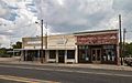
Downtown Milford
-
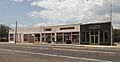
Another view of Downtown Milford
-
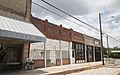
A street in Downtown Milford
.jpg)
.jpg)
.jpg)
See also
 In Spanish: Milford (Texas) para niños
