Mirrool Creek facts for kids
Quick facts for kids Mirrool |
|
|---|---|
|
Location of Mirrool Creek mouth in New South Wales
|
|
| Other name(s) | Merool |
| Country | Australia |
| State | New South Wales |
| Region | Riverina (IBRA) |
| LGAs | Bland, Griffith, Carrathool, Hay |
| Town | Mirrool, Ardlethan, Griffith |
| Physical characteristics | |
| Main source | Great Dividing Range west by south of Temora 304 m (997 ft) 34°27′56″S 147°23′57″E / 34.46556°S 147.39917°E |
| River mouth | Lachlan River northwest of Hay 84 m (276 ft) 34°24′S 144°53′E / 34.400°S 144.883°E |
| Length | 264 km (164 mi) |
| Basin features | |
| River system | Murrumbidgee catchment, Murray–Darling basin |
| Tributaries |
|
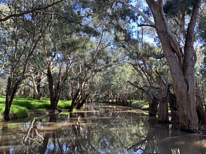
Mirrool Creek is a special kind of waterway in New South Wales, Australia. It's often called a "creek," but it acts more like a river! It's part of a bigger water system called the Murray–Darling basin, which is super important for Australia. Mirrool Creek flows through a region known as the Riverina. Sometimes, its path isn't clear, and it can even disappear underground in some places.
Contents
The Journey of Mirrool Creek
Mirrool Creek starts its journey in a place called the Ingalba Nature Reserve. This is about 15 kilometres (9.3 mi) west of the town of Temora. The water that forms the creek comes from the Great Dividing Range, a large mountain range.
Flowing Through the Land
The creek flows in different directions, generally heading northwest, then west, then north, and then west again. It travels for about 115 kilometres (71 mi). Along the way, four smaller streams join it, adding more water. After this long stretch, the creek's path becomes unclear about 3 kilometres (1.9 mi) south of Barellan. It's like it takes a break from flowing above ground!
Reappearing and Continuing
Mirrool Creek then reappears about 20 kilometres (12 mi) east of Griffith. From there, it flows for another 75 kilometres (47 mi) towards the west and southwest. It passes by towns like Yenda, Bilbul, Hanwood, and Griffith. After this, it turns northwest and flows into a place called Barren Box Swamp. Here, the water spreads out and doesn't flow as a clear creek anymore.
Final Stretch to the Lachlan River
The creek rises again southwest of the village of Goolgowi. It flows west and then southwest, with one more small stream joining it. Finally, Mirrool Creek meets the Lachlan River north of the town of Hay. Over its entire 264 kilometres (164 mi) length, the creek drops about 191 metres (627 ft) in elevation, which means it flows downhill quite a bit!
Where Roads Cross the Creek
Many important roads cross over Mirrool Creek. You can find it under the Newell Highway near the town of Mirrool and again at Ardlethan. The Kidman Way crosses it south of Hanwood. The Mid-Western Highway crosses it northeast of Hay, and the Cobb Highway crosses it northwest of Hay.
 | Anna J. Cooper |
 | Mary McLeod Bethune |
 | Lillie Mae Bradford |


