
Monida Pass facts for kids
Quick facts for kids Monida Pass |
|
|---|---|

Beaver Canyon
|
|
| Elevation | 6,870 ft (2,094 m) |
| Traversed by | |
| Location | Clark County, Idaho / Beaverhead County, Montana, United States |
| Range | Bitterroot Range, Rocky Mountains |
| Coordinates | 44°33′31″N 112°18′20″W / 44.55861°N 112.30556°W |

Monida Pass
Location in Idaho
|
|
Monida Pass is a high mountain pass located in the Rocky Mountains of the northwestern United States. It sits right on the border between Idaho and Montana. This pass is an important spot because it's where Interstate 15, a major highway, crosses the mountains. It also used to be a key route for the Union Pacific Railroad.
Contents
What is Monida Pass?
Monida Pass is a special place in the Rocky Mountains. It's a high point where you can cross from one side of a mountain range to the other. The pass is located at an elevation of about 6,870 feet (2,094 meters) above sea level for the highway. The nearby railroad track is slightly lower, at 6,820 feet (2,079 meters).
Where is Monida Pass Located?
This pass is found on the Continental Divide. This is a line that separates which way water flows across North America. Water on one side flows to the Pacific Ocean, and water on the other side flows to the Atlantic Ocean. Monida Pass is part of the Bitterroot Range and connects the Beaverhead Mountains and the Centennial Mountains.
The name "Monida" comes from the two states it separates: "Mon" from Montana and "-ida" from Idaho. It forms part of the border between eastern Idaho and southwestern Montana. The pass is located between the towns of Spencer in Clark County and Lima in Beaverhead County.
Waterways and Railways
On the Idaho side of the pass, you'll find Beaver Creek running through Beaver Canyon, Idaho. This canyon was an important route for the Utah and Northern Railway back in 1880. Today, the Union Pacific Railroad still uses this route.


History and Transportation
The Monida Pass area has a rich history, especially related to transportation.
Old Towns and Ghost Towns
The Union Pacific Railroad once had a plant in Humphrey, Idaho, where they made ice. Today, Humphrey is a ghost town, meaning almost no one lives there anymore. Monida, Montana, which is close to the top of the pass, is also nearly a ghost town. Only a few people live there now. Its elevation is 6,780 feet (2,067 meters), which is a bit lower than the pass itself.
Stagecoaches and Modern Highways
In the late 1800s, stagecoaches used to carry tourists from the railroad at Monida Pass to Yellowstone National Park. This was a popular way to travel until the Union Pacific built a new branch line directly to the park over Reas Pass.
Today, Interstate 15, also known as the "Veterans Memorial Highway," runs through Monida Pass. This major highway continues north all the way to the border with Canada at Sweetgrass.
Images for kids
-
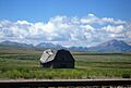
2008 photo of Stage Coach Barn for travel north to Dillon and east to Yellowstone

See also
 In Spanish: Monida Pass para niños
