Montclair, California facts for kids
Quick facts for kids
Montclair, California
|
|
|---|---|

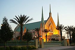
Iglesia Ni Cristo chapel
|
|

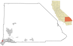
Location of Montclair in California
|
|
| Country | |
| State | |
| County | San Bernardino |
| Incorporated | April 25, 1956 |
| Area | |
| • Total | 5.53 sq mi (14.33 km2) |
| • Land | 5.53 sq mi (14.33 km2) |
| • Water | 0.00 sq mi (0.00 km2) 0% |
| Elevation | 1,066 ft (325 m) |
| Population
(2020)
|
|
| • Total | 37,865 |
| • Density | 6,847/sq mi (2,642.4/km2) |
| Time zone | UTC-8 (PST) |
| • Summer (DST) | UTC-7 (PDT) |
| ZIP Code |
91763
|
| Area code(s) | 909 |
| FIPS code | 06-48788 |
| GNIS feature IDs | 252320, 2411141 |
Montclair is a city located in the Pomona Valley area of Southern California. It is in the southwestern part of San Bernardino County, California. The city is about 35 miles (56 km) east of downtown Los Angeles. In 2020, the city had a population of 37,865 people.
Contents
History of Montclair
Early Inhabitants and Settlements
The first known people to live in this area were the Serrano tribe of Native Americans. They built their village along a creek called Arroyo de los Alisos. This creek is now known as San Antonio Creek. It flowed along what is now Mills Avenue, which is the western edge of Montclair.
In 1897, a place called "Township of Marquette" was started in the area that is now Montclair. A few years later, in 1900, a large piece of land, about 1,000 acres (405 hectares), was mapped out. This area was named "Monte Vista."
Growth and Renaming the City
In 1907, a small community called "Narod" was created south of Monte Vista. For the first half of the 1900s, the area was mostly covered with citrus orchards. These were farms growing oranges, lemons, and other citrus fruits.
After World War II, more homes were built in the Monte Vista area. Because of this growth, the Monte Vista tract officially became a city on April 25, 1956. It was named the City of Monte Vista.
However, there was a problem with the name. The Post Office would not open an office in Monte Vista. This was because another community in Northern California already had a similar name. To fix this, the city was renamed Montclair on April 8, 1958.
Geography and Location
Where is Montclair?
Montclair is surrounded by several other cities. To its west is Pomona. To the north, you'll find Claremont and Upland. Ontario is to the east, and Chino is to the south.
The city is right on the border with Los Angeles County. It is part of the Pomona Valley and also belongs to a larger area known as the Inland Empire region.
Major Roads
The San Bernardino Freeway (I-10) is a big highway that runs through the northern part of Montclair. This freeway helps people travel to and from the city.
Population and People
| Historical population | |||
|---|---|---|---|
| Census | Pop. | %± | |
| 1960 | 13,546 | — | |
| 1970 | 22,546 | 66.4% | |
| 1980 | 22,628 | 0.4% | |
| 1990 | 28,434 | 25.7% | |
| 2000 | 33,049 | 16.2% | |
| 2010 | 36,664 | 10.9% | |
| 2019 (est.) | 40,083 | 9.3% | |
| U.S. Decennial Census | |||
Population in 2010
According to the 2010 census, Montclair had a population of 36,664 people. This means there were about 6,645 people living in each square mile (2,566 people per square kilometer).
The census showed that most people, about 98.9% of the population, lived in homes. Only a small number lived in group homes or institutions.
There were 9,523 households in Montclair. About 52% of these households had children under 18 living in them. Many households were married couples living together. The average household had about 3.81 people. The average family had about 4.09 people.
The median age of people in Montclair was 30.7 years. This means half the people were younger than 30.7 and half were older. About 29.3% of the population was under 18 years old.
Most homes were owned by the people living in them (59.7%). The rest were rented (40.3%).
Population in 2000
In the census of 2000, Montclair had 33,049 people. There were 8,800 households. The population density was about 6,482 people per square mile (2,503 people per square kilometer).
About 47.5% of households had children under 18. The average household size was 3.7 people. The average family size was 4.0 people.
The median age was 29 years. About 33.1% of the population was under 18.
The median income for a household was $30,797 per year. For a family, it was $32,815 per year. About 27.4% of individuals and 34.2% of families lived below the poverty line.
Transportation Hub
Montclair has a big transportation center called the Montclair Transcenter. This is a major place for buses and trains. Many people use it daily to travel. You can find connections for Metrolink trains, Foothill Transit buses, Omnitrans buses, and the Silver Streak bus service. These services can take you to downtown Los Angeles and other places in between.
Famous People from Montclair
Montclair has been home to several notable people, especially in sports:
- Nick Rimando (born 1979), a retired professional soccer player who played in Major League Soccer.
- Vince Velasquez (born 1992), a professional baseball pitcher who has played for teams like the Philadelphia Phillies.
- Matt Wise (born 1975), a retired professional baseball pitcher. He later became a bullpen coach for the Los Angeles Angels.
- Terry Kirkman (born 1939), a retired vocalist and wind instrument player for the music group The Association.
See also
 In Spanish: Montclair (California) para niños


