
Montour Run facts for kids
Quick facts for kids Montour Run |
|
|---|---|

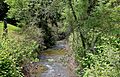
Montour Run looking upstream near its mouth in Rupert
|
|
| Physical characteristics | |
| Main source | western Montour Township, Columbia County, Pennsylvania |
| River mouth | Fishing Creek in eastern Montour Township, Columbia County, Pennsylvania |
| Length | 3.1 mi (5.0 km) |
| Basin features | |
| Progression | Fishing Creek Susquehanna River Chesapeake Bay |
| Basin size | 4.7 sq mi (12 km2) |
Montour Run is a small stream in Columbia County, Pennsylvania. It flows into Fishing Creek. Montour Run is the last stream to join Fishing Creek before it flows into the Susquehanna River. It is about 3.1 miles (5.0 km) long. The area of land that drains into Montour Run is about 4.7 square miles (12 km2). This area is mostly in Montour Township, Columbia County, and Cooper Township, Montour County. Small fish called minnows live in the stream.
Contents
Where Does Montour Run Flow?

Montour Run starts in the western part of Montour Township. This is close to the western edge of Columbia County. Its starting point is just south of U.S. Route 11 and near a place called Grovania.
The stream first flows east for a short distance. It passes by a small landing strip and generally follows U.S. Route 11. Then, it turns to flow southeast. Along this path, it receives water from a small, unnamed stream that comes from a quarry.
After this, Montour Run changes direction again. It flows northeast and then east for a bit. It continues to follow U.S. Route 11. The stream goes through a pond and crosses under Pennsylvania Route 42. Finally, it turns southeast and meets Fishing Creek near the village of Rupert.
Understanding Water Quality in Montour Run
The water in Montour Run carries a lot of sediment. Sediment is like dirt, sand, and small rocks that get washed into the stream. About 11,638 pounds (5,279 kg) of sediment flows through Montour Run every day. This adds up to about 4,248,000 pounds (1,927,000 kg) each year.
Most of this sediment comes from farm fields, specifically croplands. About 3,550,800 pounds (1,610,600 kg) of the yearly sediment comes from these farms. Other sources include hay and pastures, and even the stream banks themselves. Some sediment also comes from developed areas and forests.
The Pennsylvania Department of Environmental Protection sets rules for clean water. Most parts of Montour Run do not meet these rules for water quality. This means the water has too much sediment or other things in it. However, one small stream that flows into Montour Run in the northwest does meet the clean water standards.
The amount of rain in the Montour Run area is about 39.4 inches (100 cm) per year. The amount of water that runs off the land into the stream is about 3.1 inches (7.9 cm) per year. The water in Montour Run can also get quite warm.
Land and Rocks Around the Stream

The area around Montour Run is part of the ridge and valley region. This means there are long, parallel ridges and valleys. The land here ranges from less than 500 feet (150 m) to over 1,220 feet (370 m) above sea level.
The rocks under the ground in this area are mostly shale (50%) and sandstone (25%). The rest are a mix of different sedimentary rocks and some carbonate rock. Some of these rocks, like the Mahantango Formation, are very old, from a time called the Middle Devonian period.
The soil in the Montour Run area is mostly a type that drains water well. The stream itself is about 10 feet (3.0 m) wide. Its banks sometimes wear away, which is called erosion.
The Montour Run Watershed

The watershed of Montour Run covers about 4.7 square miles (12 km2). A watershed is all the land where water drains into a particular stream or river. This watershed is in Montour Township and Cooper Township.
A large part of the land in the watershed is used for farming. About 45.7% is cropland, hay fields, and pastures. Forests cover about 40.5% of the land. Some areas have "low-intensity development," which means houses or small buildings. A very small part, 0.7%, is wetland.
There are about 10.8 miles (17.4 km) of streams in the Montour Run watershed. Some parts of the stream, especially in the lower areas, have wetlands nearby and steep slopes.
History of the Name
Montour Run gets its name from Madame Montour. She was a famous Native American woman who lived in Pennsylvania in the 1700s.
A stone arch bridge was built over Montour Run near Bloomsburg in 1880. This bridge was repaired in 1927. It is about 29.9 feet (9.1 m) long. In 2009, about 150 vehicles crossed this bridge every day.
Animals Living in Montour Run
The Pennsylvania Department of Environmental Protection considers Montour Run a "coldwater fishery." This means it's a good place for fish that like cold water. However, the only fish found living in Montour Run are minnows.
The plants and trees along the stream banks are called the riparian buffer. In some places along Montour Run, this buffer is not very wide. Also, in the upper parts of the watershed, farmers do not always use conservation farming methods. These methods help protect the soil and water.
Images for kids
-
Montour Run looking upstream near its mouth in Rupert
