Mount Barnard (California) facts for kids
Quick facts for kids Mount Barnard |
|
|---|---|

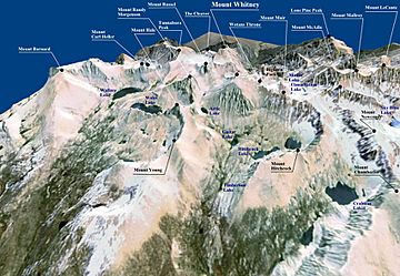
A 3D image of Mount Whitney based on topographic data from NASA and World Imagery. Mount Barnard mount appears in the upper left.
|
|
| Highest point | |
| Elevation | 13,996 ft (4,266 m) NAVD 88 |
| Prominence | 932 ft (284 m) |
| Parent peak | Mount Tyndall |
| Listing |
|
| Geography | |
| Location | Inyo / Tulare counties, California, U.S. |
| Parent range | Sierra Nevada |
| Topo map | USGS Mount Williamson |
| Climbing | |
| First ascent | September 25, 1892 by W. L. Hunter, John Hunter, William Hunter and C. Mulholland. |
| Easiest route | Easy scramble, class 2 |
Mount Barnard is a very tall mountain in the U.S. state of California. It is known for being the highest "thirteener" in the country. A thirteener is a mountain peak that is between 13,000 and 13,999 feet (about 3,962 to 4,267 meters) high.
This mountain is part of the Sierra Nevada mountain range. It sits right on the border between Tulare and Inyo counties. Mount Barnard is about 2 miles (3.2 kilometers) southwest of Mount Williamson. Mount Williamson is the second-highest peak in California. Mount Barnard itself is the twelfth-highest peak in the state.
First Climb and Naming
The first time people successfully climbed Mount Barnard was on September 25, 1892. A group of climbers named W. L. Hunter, John Hunter, William Hunter, and C. Mulholland made this first ascent.
They decided to name the peak in honor of Edward Emerson Barnard. He was a very famous astronomer. An astronomer is a scientist who studies stars, planets, and space.
 | Precious Adams |
 | Lauren Anderson |
 | Janet Collins |


