Mount Billy Mitchell (Chugach Mountains) facts for kids
Quick facts for kids Mount Billy Mitchell |
|
|---|---|

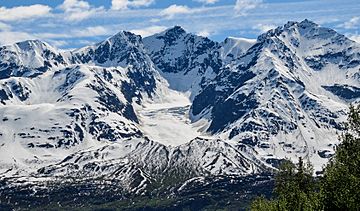
View of the north (leeward) face of Mount Billy Mitchell from mile marker 48 along the Richardson Highway. An unnamed glacier is visible in the cirque.
|
|
| Highest point | |
| Elevation | 7,217 ft (2,200 m) NGVD 29 |
| Listing | Mountains of Alaska |
| Geography | |
| Parent range | Chugach Mountains |
| Topo map | USGS Valdez A-4 |
Mount Billy Mitchell is a tall mountain in the Chugach Mountains of Alaska, USA. It stands about 6,919 feet (2,109 meters) high. You can find it about 35 miles (56 km) east of Valdez and 12 miles (19 km) west of the Copper River.
This mountain is easy to spot from the Richardson Highway. It's a clear landmark between mile markers 43 and 51, as the highway passes right by its western side.
The mountain is named after William "Billy" Mitchell (1879–1936). He was a general in the United States Army Air Service. Many people call him the "father of the United States Air Force" because of his important ideas about air power.
Contents
Why is Mount Billy Mitchell called that?

Mount Billy Mitchell was named to honor William "Billy" Mitchell. He played a big role in setting up telegraph lines in Alaska. This happened during the time of the Klondike Gold Rush, when many people were moving to Alaska to find gold.
In 1900, the U.S. Congress gave money to build a communication system in Alaska. This system would connect military bases and gold rush towns using telegraph lines. Lieutenant Mitchell helped lead this huge project.
Building the Alaska Telegraph System
The construction of the telegraph system, called the Washington-Alaska Military Cable and Telegraph System (WAMCATS), started in 1900. It was a massive undertaking! The lines stretched from Valdez in southern Alaska all the way to Nome on the Seward Peninsula.
By 1904, the WAMCATS system was fully working. It included almost 1,400 miles (2,253 km) of telegraph cable over land. There were also more than 2,000 miles (3,219 km) of underwater cables. Plus, a 107-mile (172 km) wireless telegraphy system crossed the Norton Sound to Nome.
This telegraph line was the first to connect American bases in Alaska with each other and with Washington, D.C. It was a huge achievement for its time. The WAMCATS system even included the first successful long-distance radio operation in the world.
Remembering Billy Mitchell's Work
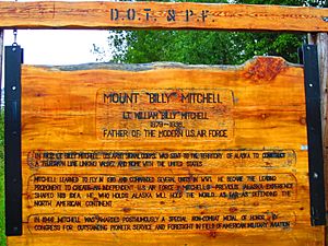
You can find a historical marker along the Richardson Highway. It's near where the highway crosses the Tiekel River. This marker was placed by the Alaska Department of Transportation & Public Facilities.
The marker tells us about Lieutenant Billy Mitchell's work in Alaska. It explains that in 1902, he helped build the telegraph line connecting Valdez and Nome to the rest of the United States. It also mentions that Mitchell later learned to fly and became a strong supporter of creating an independent U.S. Air Force. His time in Alaska helped shape his ideas about how important Alaska was for defending North America.
What about the glaciers on Mount Billy Mitchell?
The Chugach Mountains get a lot of snow because they are close to the Gulf of Alaska. Storms from the Gulf bring heavy snow to this area. Valdez, for example, gets about 279 inches (709 cm) of snow each year, which is more than almost anywhere else in the United States!
Over thousands of years, this heavy snowfall has created glaciers on Mount Billy Mitchell. You can see them especially on the mountain's north side. However, even with all this snow, the glaciers on Mount Billy Mitchell have been shrinking. This is because more ice is melting than new snow is building up. So, the glaciers have gotten much smaller in recent years.
 | James Van Der Zee |
 | Alma Thomas |
 | Ellis Wilson |
 | Margaret Taylor-Burroughs |


