
Mount Carmel, Pennsylvania facts for kids
Quick facts for kids
Borough of Mount Carmel
|
||
|---|---|---|

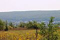
View of Mount Carmel from the northeast
|
||
|
||

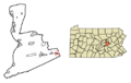
Location of Mount Carmel in Northumberland County, Pennsylvania.
|
||

Borough of Mount Carmel
Location in Pennsylvania

Borough of Mount Carmel
Location in the United States
|
||
| Country | United States | |
| State | Pennsylvania | |
| County | Northumberland | |
| Settled | 1770 | |
| Incorporated, Township | November 14, 1854 | |
| Incorporated, Borough | November 3, 1862 | |
| Area | ||
| • Total | 0.66 sq mi (1.71 km2) | |
| • Land | 0.66 sq mi (1.71 km2) | |
| • Water | 0.00 sq mi (0.00 km2) | |
| Elevation
(center of borough)
|
1,100 ft (300 m) | |
| Highest elevation
(southeastern boundary of borough)
|
1,300 ft (400 m) | |
| Lowest elevation
(Shamokin Creek on western borough boundary)
|
1,035 ft (315 m) | |
| Population
(2020)
|
||
| • Total | 5,725 | |
| • Density | 8,648.04/sq mi (3,341.16/km2) | |
| Time zone | UTC-5 (EST) | |
| • Summer (DST) | UTC-4 (EDT) | |
| ZIP code |
17851
|
|
| Area codes | 570 and 272 | |
| FIPS code | 42-51496 | |

Mount Carmel is a small town, called a borough, in Northumberland County, Pennsylvania. It's part of the beautiful Coal Heritage Region. In 2020, about 5,725 people lived there. Mount Carmel is located in the Coal Region, about 88 miles (141 km) northwest of Philadelphia. It is completely surrounded by Mount Carmel Township.
Contents
History of Mount Carmel
Mount Carmel got its name from a sawmill worker named Albert Bradford. He thought the area was so high up and pretty, like the holy mountain in Israel, that it deserved a special name.
Mount Carmel started as a place for cutting down trees. Coal was first found here in 1790 by Isaac Tomlinson. It took 24 years for the first coal, called anthracite, to be shipped out.
In 1812, the Mount Carmel Inn opened. It was a good spot on the Centre Turnpike, a main road between Pottsville and Danville. In 1854, a railroad was finished, connecting Shamokin to Mount Carmel. This helped many coal mines open in the area. The town became a borough in 1862.
Mount Carmel was one of the first towns in the United States to have electric streetlights! Thomas Edison himself put one of his first power plants here in 1883. It was only the seventh Edison plant in the whole world.
In the past, coal mining was a huge industry here. The borough also had factories that made things like miners' caps, cement blocks, cigars, and shirts. There were also large silk mills, machine shops, and lumber yards. Today, the area focuses on making paper and plastic products.
Important Dates in Mount Carmel's History
- 1681: Charles II of England gave land to William Penn, creating Pennsylvania.
- 1729: Lancaster County was formed.
- 1749: The land for Mount Carmel was bought from the Six Nations.
- 1770: The first European settlers arrived in the area.
- 1772: Northumberland County was formed.
- 1783: The Treaty of Paris recognized Pennsylvania's independence.
- 1790: Anthracite coal was discovered nearby by Isaac Tomlinson.
- 1808: The Centre Turnpike, an important road, opened.
- 1812: The Mount Carmel Inn opened.
- 1830s: Coal mining began.
- 1846: The first Post Office opened.
- 1854: Mount Carmel Township was created.
- 1855: The first church, Evangelical Grace Church, opened.
- 1862: Mount Carmel became an official borough.
- 1883: The Edison Electric Illuminating Company of Mount Carmel was started.
- 1894: A trolley line connected Shamokin with Mount Carmel.
- 1906: The "Miners Dispute" happened, where striking miners were injured.
- 1931: Mount Carmel High School's "Silver Bowl" football stadium opened with lights for night games.
- 1948: United Airlines Flight 624 crashed nearby, sadly killing everyone on board.
- 1950: The coal mining industry started to slow down.
- 2003: A new bridge, called a viaduct, was built to replace an old one.
Geography and Nature


Mount Carmel is located in the ridge-and-valley part of the Appalachian Mountains. Water from the town flows into the Shamokin Creek, which then goes into the Susquehanna River.
The borough is about 0.7 square miles (1.7 km2) in size. Most of Mount Carmel is flat and built up with buildings. Pennsylvania Route 61 is a main road that goes through the town.
People and Population
| Historical population | |||
|---|---|---|---|
| Census | Pop. | %± | |
| 1870 | 1,289 | — | |
| 1880 | 2,378 | 84.5% | |
| 1890 | 8,254 | 247.1% | |
| 1900 | 13,179 | 59.7% | |
| 1910 | 17,532 | 33.0% | |
| 1920 | 17,469 | −0.4% | |
| 1930 | 17,967 | 2.9% | |
| 1940 | 17,780 | −1.0% | |
| 1950 | 14,222 | −20.0% | |
| 1960 | 10,760 | −24.3% | |
| 1970 | 9,317 | −13.4% | |
| 1980 | 8,190 | −12.1% | |
| 1990 | 7,196 | −12.1% | |
| 2000 | 6,390 | −11.2% | |
| 2010 | 5,893 | −7.8% | |
| 2020 | 5,725 | −2.9% | |
| Sources: | |||
In 2000, there were 6,390 people living in Mount Carmel. Most people were White (98.56%). About 21.9% of homes had children under 18 living there. The average age of people in Mount Carmel was 45 years old.
Schools in Mount Carmel
The Mount Carmel Area School District has three schools for students:
- Mount Carmel Area Elementary School (for pre-kindergarten to 6th grade)
- Mount Carmel Area Junior High School (for 7th and 8th grade)
- Mount Carmel Area High School (for 9th to 12th grade)
Getting Around Mount Carmel
Main Roads
- Pennsylvania Route 61: This road has had different names over the years, like King's Highway and Centre Turnpike.
- Pennsylvania Route 54
- Pennsylvania Route 901
Train Lines

Many different train companies used to operate in Mount Carmel, helping to move coal and people. Some of these included:
- Shamokin Valley and Pottsville Railroad
- Lehigh Valley Railroad
- Reading Company
- Pennsylvania Railroad
- Shamokin Valley Railroad
- The Shamokin-Mount Carmel Electric Railway (a trolley line)
Public Transportation
The Lower Anthracite Transportation System provides bus services in Mount Carmel. These buses run on weekdays and Saturdays, connecting Mount Carmel to nearby towns. There's even a special bus route that runs during certain times of the year to Knoebels Amusement Resort, a popular amusement park!
Famous People from Mount Carmel
- Ellen Dow – an actress.
- Lieutenant General James M. Gavin (1907–1990) – a brave United States Army general, known as "The Jumping General," who led the 82nd Airborne Division during World War II.
- Henry Hynoski Sr. – an NFL football player for the Cleveland Browns.
- Vaughn Nark – a talented jazz musician.
- Edward Pinkowski – a journalist and historian.
- Marie Powers – an opera singer who performed all over Europe and on Broadway.
- James M. Quigley – a politician and lawyer.
- Brett Veach – the General Manager for the NFL football team, the Kansas City Chiefs.
Images for kids
-
View of Mount Carmel from the northeast
-
Seal of Mount Carmel Borough
-
Location of Mount Carmel in Northumberland County, Pennsylvania.
-
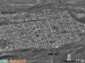
Satellite view of Mount Carmel
-
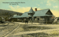
The Philadelphia and Reading RR Station in Mount Carmel, around 1917
See also
 In Spanish: Mount Carmel (Pensilvania) para niños
