
Mount Olive, North Carolina facts for kids
Quick facts for kids
Mount Olive, North Carolina
|
|||
|---|---|---|---|
 |
|||
|
|||
| Motto(s):
"We Value Hometown Tradition"
|
|||

Mount Olive, North Carolina
Location in North Carolina
|
|||
| Country | United States | ||
| State | North Carolina | ||
| Counties | Wayne, Duplin | ||
| Area | |||
| • Total | 2.74 sq mi (7.09 km2) | ||
| • Land | 2.74 sq mi (7.09 km2) | ||
| • Water | 0.00 sq mi (0.00 km2) | ||
| Elevation | 164 ft (50 m) | ||
| Population
(2020)
|
|||
| • Total | 4,198 | ||
| • Density | 1,533.24/sq mi (591.92/km2) | ||
| Time zone | UTC-5 (Eastern (EST)) | ||
| • Summer (DST) | UTC-4 (EDT) | ||
| ZIP code |
28365
|
||
| Area code(s) | 919 | ||
| FIPS code | 37-45100 | ||
| GNIS feature ID | 2406209 | ||


Mount Olive is a town located in North Carolina, a state in the United States. It is found in both Duplin and Wayne counties. In 2020, about 4,198 people lived there. Mount Olive is famous for being home to the Mt. Olive Pickle Company and the University of Mount Olive. It is also part of the Goldsboro Metropolitan Area.
Contents
Exploring Mount Olive's Past
Mount Olive has a rich history with several important buildings. Many of these places are listed on the National Register of Historic Places. This list helps protect buildings that are special because of their history or design.
- The Mount Olive High School (Former)
- The Mount Olive Historic District
- The Perry-Cherry House
- The Southerland-Burnette House
- The former United States Post Office
- The Vernon
A railroad called the Wilmington & Raleigh Railroad was finished in 1840. This railroad, later renamed the Wilmington & Weldon Railroad, ran right through Mount Olive. The land for the railroad was sold by Adam Winn Sr., who was a well-known free Black landowner.
Where is Mount Olive Located?
Mount Olive is mostly in the southern part of Wayne County. A small piece of the town also reaches into Duplin County.
Roads and Travel
Major roads help people travel to and from Mount Olive. U.S. Route 117 is a large highway that runs along the western side of the town. It connects Mount Olive to Goldsboro to the north and Warsaw to the south.
North Carolina Highway 55 crosses US 117 in Mount Olive. This highway leads east to Kinston and west to Newton Grove. The town covers an area of about 7 square kilometers (2.7 square miles).
Who Lives in Mount Olive?
The population of Mount Olive changes over time. Here's how the number of people living there has grown:
| Historical population | |||
|---|---|---|---|
| Census | Pop. | %± | |
| 1890 | 393 | — | |
| 1900 | 617 | 57.0% | |
| 1910 | 1,071 | 73.6% | |
| 1920 | 2,297 | 114.5% | |
| 1930 | 2,685 | 16.9% | |
| 1940 | 2,929 | 9.1% | |
| 1950 | 3,732 | 27.4% | |
| 1960 | 4,673 | 25.2% | |
| 1970 | 4,914 | 5.2% | |
| 1980 | 4,876 | −0.8% | |
| 1990 | 4,582 | −6.0% | |
| 2000 | 4,567 | −0.3% | |
| 2010 | 4,589 | 0.5% | |
| 2020 | 4,198 | −8.5% | |
| U.S. Decennial Census | |||
Understanding the 2020 Census
In 2020, the town had 4,198 people living in 1,803 households. A household is a group of people living together in one home. There were also 985 families.
The people living in Mount Olive come from many different backgrounds. Here's a look at the different groups:
| Race | Number | Percentage |
|---|---|---|
| White (non-Hispanic) | 1,463 | 34.85% |
| Black or African American (non-Hispanic) | 2,060 | 49.07% |
| Native American | 14 | 0.33% |
| Asian | 14 | 0.33% |
| Other/Mixed | 112 | 2.67% |
| Hispanic or Latino | 535 | 12.74% |
New Neighbors in Mount Olive
Between 2010 and 2012, many people from Haiti came to live in Mount Olive and the areas nearby. They came because there were jobs available at places like the Butterball turkey processing plant and other meat factories. These jobs are often hard work, but they provide opportunities for new residents.
The Famous Pickles of Mount Olive
Mount Olive is well-known for its pickles! The Mt. Olive Pickle Company started in 1926. You can find it on the corner of Cucumber and Vine streets.
Pickle Festival Fun
Every year, the town hosts the North Carolina Pickle Festival. This fun event happens on the last full weekend of April. It's a big celebration put on by both the community and the Mt. Olive Pickle Company.
New Year's Pickle Drop
On New Year's Eve, the Mt. Olive Pickle Company has a unique tradition. They drop a three-foot pickle down a flagpole into a pickle tank! This special event happens at 7 p.m., not midnight. The first pickle drop was on New Year's Eve in 1999.
Mount Olive's Natural Setting
Mount Olive is part of the Atlantic coastal plain. This means the land is generally flat and close to the coast.
Learning and Education in Mount Olive
Education in Mount Olive is managed by the Wayne County Public Schools system and Duplin County Schools.
Local Schools
Schools right in Mount Olive include Carver Elementary School and Mount Olive Middle School. Just outside of town, students can attend Southern Wayne High School in Dudley or North Duplin Jr & Sr High School.
Higher Education Opportunities
For students who want to continue their education after high school, there are options nearby. Wayne Community College is in Goldsboro. The University of Mount Olive is a private college located right in town.
Getting Around Mount Olive
Mount Olive has several ways for people to travel, whether by air, road, or train.
Air Travel
- Local Airport: Mount Olive Municipal Airport is available for smaller corporate and private planes.
- Nearby Jetport: The Kinston Regional Jetport (KISO) offers flights to places like Orlando, Florida.
- Major Airport: For more flights, the Raleigh-Durham International Airport is the closest large airport. It has flights to many cities around the world.
Interstate Highways
The closest major highway is I-40. It is about 9 miles south of Mount Olive, near Faison.
Train Travel
Mount Olive does not have passenger train service directly. The nearest Amtrak station is in Selma. However, CSX freight trains do travel through Mount Olive.
Bus Service
Bus service is available through Greyhound. The closest Greyhound station is in nearby Goldsboro.
Famous People from Mount Olive
Several notable people have come from Mount Olive:
- Morrie Aderholt: A former professional baseball player in the MLB.
- Leora Jones: A former handball player who competed in the Olympics three times (1984, 1988, and 1992).
- Greg Warren: A former professional football player who played as a long snapper and won two Super Bowls with the Pittsburgh Steelers.
Images for kids
-
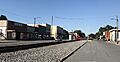
A view of Mount Olive, North Carolina.
See also
 In Spanish: Mount Olive (Carolina del Norte) para niños
