
Mount Ouray facts for kids
Quick facts for kids Mount Ouray |
|
|---|---|

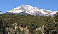
Mount Ouray above Marshall Pass in 1899.
|
|
| Highest point | |
| Elevation | 13,961 ft (4255.4 m) NAVD88 |
| Prominence | 2659 ft (810 m) |
| Isolation | 13.58 mi (21.9 km) |
| Listing |
|
| Geography | |

Mount Ouray
Location in Colorado
|
|
| Location | Chaffee and Saguache counties, Colorado, United States |
| Parent range | Sawatch Mountains |
| Topo map | USGS 7.5' topographic map Mount Ouray, Colorado |
| Climbing | |
| Easiest route | West ridge, class 2 |

Mount Ouray is a very tall mountain in the southern part of the Sawatch Range. This mountain range is part of the Rocky Mountains in North America. Mount Ouray is often called a "thirteener" because it stands at 13,961 feet (4,255.4 meters) high. It is located in the San Isabel National Forest in Colorado, United States. The mountain sits on the border between Chaffee and Saguache counties. It was named to honor Chief Ouray, a respected leader of the Ute people.
About Mount Ouray
Mount Ouray is the very southern tip of the Sawatch Range. It rises about 7,000 feet above the Arkansas River Valley. Another important mountain pass, Monarch Pass, is about four miles northwest of Mount Ouray.
Who was Chief Ouray?
The mountain is named after Chief Ouray, a famous leader of the Ute people. He was known for working for peace between his people and settlers. Not far from Mount Ouray, about a mile to the northwest, is Mount Chipeta. This mountain is named after Chief Ouray's wife, Chipeta.
How to Climb Mount Ouray
The most common way to climb Mount Ouray is along its west ridge. Hikers usually start at Marshall Pass. From there, they follow the Continental Divide north. The Continental Divide is a line of high points that separates rivers flowing to the Pacific Ocean from those flowing to the Atlantic. Once hikers reach the west ridge of Mount Ouray, they can hike east along this ridge to reach the top. This route is considered a "class 2" climb, which means it involves some easy scrambling but no technical climbing gear.
Images for kids
-
Mount Ouray, east aspect

