
Mount Pelion East facts for kids
Quick facts for kids Mount Pelion East |
|
|---|---|

Mount Pelion East
|
|
| Highest point | |
| Elevation | 1,461 m (4,793 ft) |
| Prominence | 335 m (1,099 ft) |
| Isolation | 3.23 km (2.01 mi) |
| Parent peak | Mount Ossa |
| Listing | 25th highest mountain in Tasmania |
| Geography | |

Mount Pelion East
Location in Tasmania
|
|
| Location | Central Highlands, Tasmania, Australia |
| Parent range | Pelion |
| Topo map | Tasmap Cathedral 1:25000 |
| Geology | |
| Age of rock | Jurassic |
| Mountain type | Dolerite |
| Climbing | |
| Easiest route | Walk / hike via the Overland Track from Pelion Gap |
Mount Pelion East is a cool mountain found in the Central Highlands area of Tasmania, Australia. It's part of the amazing Cradle Mountain-Lake St Clair National Park.
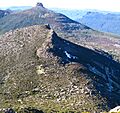
This mountain stands tall at about 1,461 meters (that's over 4,700 feet!) above sea level. It's the 25th tallest mountain in Tasmania. It's even a little bit higher than the famous Frenchmans Cap. Unlike its neighbor, Mount Pelion West, Pelion East looks more like a sharp spire. This unique shape was created by powerful glaciers thousands of years ago.
Contents
Where is Mount Pelion East?
Mount Pelion East is located in a beautiful part of Tasmania. To its west, you'll find Mount Pelion West. To the north is Lake Ayr, and to the east is Curate Bluff, which is part of the Cathedral Mountain range. South of it is Mount Massif.
What is the mountain made of?
The mountain is mostly made of a type of rock called dolerite. The lower parts of the mountain are covered in low plants, including a type of scrub called scoparia.
How to Visit Mount Pelion East
Mount Pelion East is about halfway between Pelion Hut and Kia Ora Hut. These are two stops along the famous Overland Track. This walking trail passes very close to the mountain, about 1,000 meters away.
Walking the Overland Track
You can get to Mount Pelion East by walking the Overland Track from Cradle Mountain. If you plan to walk between November and April, you'll need to book your trip and pay a fee. During this time, only a limited number of people can walk the track, and they must go from north to south.
If you visit during the off-season, you can also start your walk from the south at Lake St Clair. Another way to reach the area is by using the Arm River and Innes Tracks. These tracks meet the Overland Track at Pelion Plains.
Climbing to the Summit
You can climb Mount Pelion East from the Overland Track. The track passes very close to the mountain at a spot called Pelion Gap. This gap is about 1,126 meters high. From there, you can begin your climb to the top of Mount Pelion East.
Images for kids
-
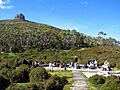
Pelion Gap and Mount Pelion East
-
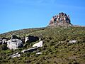
Pelion East from the lower slopes
-
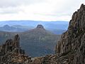
Mount Pelion East left, Cathedral Mountain centre and Mount Ossa right, as seen from Mount Pelion West
-
Mount Pelion East from high on Mount Ossa
-
Mount Doris in the foreground and Mount Pelion East behind - from the lower slopes of Mount Ossa
-
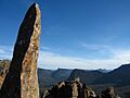
Summit
-
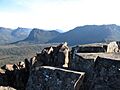
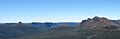
Mount Massif on the left and Mount Ossa on the right as seen from the summit of Mount Pelion East


