
Mount Pulitzer (Washington) facts for kids
Quick facts for kids Mount Pulitzer |
|
|---|---|

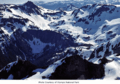
Mount Pulitzer, northeast aspect
|
|
| Highest point | |
| Elevation | 6,283 ft (1,915 m) |
| Prominence | 923 ft (281 m) |
| Isolation | 2.58 mi (4.15 km) |
| Parent peak | Stephen Peak (6,418 ft) |
| Geography | |

Mount Pulitzer
Location in Washington (state)

Mount Pulitzer
Location in the United States
|
|
| Location | Olympic National Park Jefferson County, Washington, US |
| Parent range | Olympic Mountains |
| Topo map | USGS Mount Queets |
| Geology | |
| Age of rock | Eocene |
| Climbing | |
| Easiest route | class 3 scrambling East ridge |
Mount Pulitzer, also called Snagtooth, is a tall mountain peak. It stands 6,283-foot (1,915-metre) high. This mountain is located inside Olympic National Park in Jefferson County, Washington state.
Mount Pulitzer is the sixth-highest peak in the Bailey Range. This range is part of the larger Olympic Mountains. Its closest neighbor is Mount Ferry, which is 0.58 mi (0.93 km) to the northeast. The closest taller mountain is Stephen Peak, 2.58 mi (4.15 km) north. Mount Olympus is 6.8 mi (10.9 km) to the southwest. On a clear day, you can see Mount Pulitzer from the visitor center at Hurricane Ridge. Rain and melting snow from the mountain flow into the Elwha and Hoh Rivers.
What's in a Name?
This mountain was named by the Seattle Press Expedition in 1889-1890. They named it after Joseph Pulitzer (1847–1911). He was a famous newspaper publisher who owned the New York World newspaper. Today, his name is best known for the Pulitzer Prize. This is a very important award for achievements in journalism, literature, and music. The mountain was first called Mount Ferry before it got its current name.
Weather and Climate
Mount Pulitzer is in a marine west coast climate zone. This means it has mild, wet winters and cool, drier summers. This climate helps a small, unnamed glacier survive on the mountain's north side.
Most of the weather systems start over the Pacific Ocean. They then move northeast towards the Olympic Mountains. When these weather systems hit the tall peaks, the air is forced to rise. As it rises, it cools down and drops its moisture as rain or snow. This is called Orographic lift. Because of this, the Olympic Mountains get a lot of rain and snow, especially in winter.
During winter, the weather is often cloudy. But in summer, high-pressure systems over the Pacific Ocean bring clear skies. This means July through September are usually the best months to visit and climb the mountain.
How the Mountain Was Formed
The Olympic Mountains are made of special types of rock. These rocks were formed from pieces of the Earth's crust that were pushed up. They are mostly Eocene sandstone and other rocks that came from the ocean floor.
The mountains got their shape during the Pleistocene era. This was a time when large sheets of ice, called glaciers, covered much of the Earth. These glaciers moved and carved out the valleys and peaks we see today. They advanced and retreated many times, shaping the landscape.
Images for kids
-
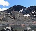
Mt. Pulitzer, north aspect
-
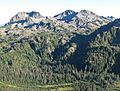
Mt. Ferry (left) and Mt. Pulitzer (right of center)
-
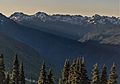
The Bailey Range seen from High Divide featuring Mt. Ferry and Mt. Pulitzer to left, and Mt. Childs on the right.
-
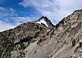
Mount Pulitzer from northeast
-
Mt. Pulitzer in upper left
.jpg)


