Mount Watson (Alaska) facts for kids
Quick facts for kids Mount Watson |
|
|---|---|

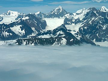
Mount Watson centered in back
|
|
| Highest point | |
| Elevation | 12,497 ft (3,809 m) |
| Prominence | 3,809 ft (1,161 m) |
| Parent peak | Mount Root (12,887 ft) |
| Listing | Highest US summits 143rd |
| Geography | |
| Location | Glacier Bay National Park Borough of Yakutat Alaska, United States |
| Parent range | Fairweather Range Saint Elias Mountains |
| Topo map | USGS Skagway A-7 |
| Climbing | |
| First ascent | June 18, 1974 |
| Easiest route | Mountaineering |
Mount Watson is a tall mountain in southeast Alaska, United States. It stands 12,497 feet (3,809 meters) high. This mountain is covered in glaciers and is part of the Fairweather Range. It's also within the larger Saint Elias Mountains. Mount Watson is the fifth-highest peak in the Fairweather Range.
The mountain is located inside Glacier Bay National Park. It is about 2 miles (3 kilometers) west of the border with Canada. Mount Watson is also about 7 miles (11.5 kilometers) north of Mount Fairweather. Mount Fairweather is the highest peak in the Fairweather Range.
The name "Mount Watson" became official in 1924. It was named after David Thompson Watson (1844-1916). He was an American lawyer who helped with a border disagreement. This disagreement was about the Alaska boundary dispute in 1903.
The first time people climbed Mount Watson was on June 18, 1974. Michael Allen, Walter Gove, Lawrence Dauelsberg, Alice Liska, and Donald Liska reached the top. They climbed using the East Ridge. Later, in April 1999, Chris Trimble and Jim Earl climbed the North Face for the first time. The best time to climb Mount Watson is usually from May to June. This is when the weather is most favorable.
Climate of Mount Watson
Mount Watson has a subarctic climate. This means it has very cold, snowy winters. The summers are mild, not too hot. Temperatures can drop below -20 degrees Celsius (-4 degrees Fahrenheit). With wind, it can feel even colder, below -30 degrees Celsius (-22 degrees Fahrenheit).
This cold climate helps keep glaciers on the mountain's slopes. A large glacier called the Grand Plateau Glacier is to the west. Water from melting glaciers and rain flows into the Gulf of Alaska.
 | Charles R. Drew |
 | Benjamin Banneker |
 | Jane C. Wright |
 | Roger Arliner Young |


