Muggins Mountains facts for kids
Quick facts for kids Muggins Mountains |
|
|---|---|

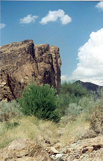
Morgan Peak in the Muggins Mountains
(peak in the distant background) Foreground-base of mountains-adjacent cliffs of wash; in view: gray-green Psorothamnus, deep-green Acacia greggii-(catclaw), blue palo verdes, and straw-colored Bebbia juncea |
|
| Highest point | |
| Peak | unnamed |
| Elevation | 1,908 ft (582 m) |
| Geography | |
| Country | United States |
| State | Arizona |
The Muggins Mountains are a mountain range in southwest Arizona, a state in the United States. They are located east of Yuma and near other mountain ranges like the Gila Mountains and Laguna Mountains. The Castle Dome Mountains are to the northeast. A special protected area called the Muggins Mountains Wilderness covers the southwest part of this range.
Contents
Exploring the Muggins Mountains
The Muggins Mountains form a shape like a triangle. They are about 10 miles (16 km) long on their southwest and southeast sides. The northern side is about 14 miles (23 km) long.
Tallest Peaks and Northern Areas
The northern part of the Muggins Mountains has the two highest points. One peak, which doesn't have a name, is about 1,908 feet (582 meters) tall. The other is Red Bluff Mountain, standing at about 1,905 feet (581 meters). The northern part of the range is inside the Yuma Proving Ground. This is a large area used by the military for testing.
Southern Areas and Wilderness
The southern part of the Muggins Mountains is next to farming areas. These include the Mohawk Valley and the Gila River Valley. To the southwest is Dome Valley, where the Gila River flows.
The Muggins Mountains Wilderness is in the southwest. It borders Dome Valley. Inside this wilderness area are two important peaks. Muggins Peak is about 1,424 feet (434 meters) tall. The Klothos Temple is another peak, about 1,666 feet (508 meters) tall.
Waterways and Landforms
In the northern part of the range, within the Yuma Proving Ground, there are flat areas, mesas, and hills. Small alluvial fans drain this northern edge. Alluvial fans are fan-shaped deposits of sand and gravel left by flowing water.
The unnamed peak in the northwest is separated from the southern mountains by Vinegaroon Wash. A large alluvial fan from the central Muggins Mountains, drained by Vinegaroon Wash, can be seen from US 95 about 4 miles (6.4 km) to the west.
Several washes also drain the southwest part of the Muggins Mountains Wilderness. These include Long Mountain Wash, Twin Tanks Wash, and Muggins Wash. They all flow southwest into the Dome Valley foothills. Morgan Wash drains the southeast border of the wilderness into Mohawk Valley.
Desert Plants and Wildlife
Water in the Muggins Mountains is very scarce. It only appears for short times during winter and spring, especially after rains. Standing water lasts longer in cooler, wetter years. Because the mountains are not very high, there are no large forests. Instead, you'll find plants that are adapted to the desert.
This area is part of the western Sonoran Desert, specifically the Yuma Desert. The main plant community here is called creosote bush scrub.
Common Desert Plants
Many types of plants thrive in this dry environment:
- Creosote bush is a very common shrub.
- Desert ironwood and palo verde are small trees.
- Catclaw acacia is a thorny bush.
- Saguaro cacti are tall, iconic desert plants.
- Ocotillo has long, spiny stems.
- Anderson thornbush and smoketree are also found here.
- Common shrubs include brittlebush, saltbush, and bebbia.
Nearby Communities
The towns closest to the Muggins Mountains are Dome, Ligurta, and Wellton. These communities are located in the Dome and Mohawk Valleys.
 | Percy Lavon Julian |
 | Katherine Johnson |
 | George Washington Carver |
 | Annie Easley |

