
Kuranda, Queensland facts for kids
Quick facts for kids KurandaQueensland |
|||||||||||||||
|---|---|---|---|---|---|---|---|---|---|---|---|---|---|---|---|

Kuranda railway station
|
|||||||||||||||

Kuranda
Location in Queensland
|
|||||||||||||||
| Population | 3,273 (2021 census) | ||||||||||||||
| • Density | 29.513/km2 (76.44/sq mi) | ||||||||||||||
| Established | 1888 | ||||||||||||||
| Postcode(s) | 4881 | ||||||||||||||
| Elevation | 330 m (1,083 ft) | ||||||||||||||
| Area | 110.9 km2 (42.8 sq mi) | ||||||||||||||
| Time zone | AEST (UTC+10:00) | ||||||||||||||
| Location |
|
||||||||||||||
| LGA(s) | Shire of Mareeba | ||||||||||||||
| State electorate(s) | Barron River | ||||||||||||||
| Federal Division(s) | Leichhardt | ||||||||||||||
|
|||||||||||||||
Kuranda is a small town in Queensland, Australia. It is located on the Atherton Tableland, surrounded by beautiful tropical rainforest. The town is very close to the Wet Tropics of Queensland World Heritage listed Barron Gorge National Park.
Kuranda is about 25 kilometers (15 miles) from Cairns. In 2021, about 3,273 people lived in Kuranda. Another small town called Myola is also part of the Kuranda area.
Contents
Exploring Kuranda's Location
Kuranda sits on the eastern edge of the Atherton Tableland. This is where the Barron River starts its journey down to the coast. The area is a vital pathway for animals, connecting different natural areas.
National Parks and Nature Reserves
Many parts of Kuranda are protected. These include the Kuranda National Park and Barron Gorge National Park. Both are part of the amazing Wet Tropics World Heritage Area. This means they are very special places for nature.
You can also find the Barron Gorge Forest Reserve and Formatine Forest Reserve nearby. Closer to the town, there is Jumrum Creek Conservation Park. This park helps protect a rare frog species called Ranoidea myola. A dam built in 1935 for a power station is now used for fun activities.
Myola is located north of Kuranda, right next to the Barron River.
A Look at Kuranda's Past
The rainforest around Kuranda has been home to the Djabugay people for over 10,000 years. Europeans started exploring and settling here in the 1800s. The name Kuranda comes from a local Aboriginal word, kuran, which refers to a type of plant.
Early Settlement and Railway
Kuranda was first settled in 1885. The railway from Cairns reached Kuranda in 1891. This railway was a big deal for the town. The current railway station was finished in 1915.
The Kuranda Post Office opened in 1891. The name Myola comes from its railway station, named in 1891. It is an Aboriginal word meaning main camp.
Schools and Community Life
Kuranda State School opened in 1892. Later, in 2007, it joined with Kuranda District State High School. They became Kuranda District State College. This new school is located in Myola.
St Saviour's Anglican Church was built in 1915. It has beautiful colorful glass windows added in 2002. In the 1930s, the Fairyland Tea Gardens became a popular spot for tourists to enjoy the rainforest.
Kuranda's Growth as a Tourist Spot
From the 1970s, Kuranda became known as the 'village in the rainforest'. This idea attracted people who wanted a different lifestyle. It also helped bring in tourists. Tourism is now a very important part of Kuranda's economy.
The Kuranda Library opened in 1996 and was updated in 2015. Today, Kuranda is still a quiet tourist town. It is famous for its art and souvenir shops.
Who Lives in Kuranda?
In 2021, the population of Kuranda was 3,273 people. A significant number of people, about 14.9%, are Aboriginal and Torres Strait Islander. Most people, 67.0%, were born in Australia. The next largest group came from England (5.7%). About 80.4% of people speak only English at home. Many people in Kuranda, about 39.2%, reported having no religion.
Special Places in Kuranda
Kuranda has some places listed for their special history:
- The Cairns-to-Kuranda railway line, also known as the Kuranda Scenic Railway, including the Kuranda railway station.
- The Kuranda Fig Tree Avenue on Coondoo Street.
Community Services and Groups
The Mareeba Shire Council runs a public library in Kuranda on Arara Street. The Kuranda Historical Society started in 2017. They collect and show items about Kuranda's history.
"The Kuranda Paper" is a monthly newspaper published by the Kuranda Media Association. The Kuranda branch of the Queensland Country Women's Association meets at the CWA Hall. St Christopher's Catholic Church is on Barang Street.
Learning in Kuranda
Kuranda offers good schools for young people:
- Kuranda District State College is a government school for all ages, from Prep (kindergarten) to Year 12. It is located on Myola Road. In 2017, it had 366 students.
- Cairns Hinterland Steiner School is a private school for students from Prep to Year 11. It is on Boyles Road. In 2017, it had 165 students.
Amazing Animals of Kuranda
Kuranda is home to a special frog, the Litoria myola. This frog is only found near a few creeks in the area. The region also has many different kinds of insects and other small creatures. You can find Australia's largest mantids, stick insects, spiders, moths, and butterflies here.
Kuranda's Weather
Because Kuranda is in the tropics, it has mild temperatures all year. It has two main seasons: a dry season and a wet season.
Kuranda is usually 2–5 °C (3.6–9 °F) cooler than Cairns. It also gets more rainy days because of the mountains. The air is often very humid, especially in residential areas near the rainforest. People sometimes call Kuranda the "air conditioned suburb of Cairns" because of its cooler weather.
In summer (January to March), temperatures rarely go above 31 °C (88 °F). This is because of the rain and clouds. Night temperatures rarely drop below 20 °C (68 °F). In winter (June to August), daytime temperatures are usually around 25 °C (77 °F). However, nights can get cooler, sometimes dropping to 8 °C (46 °F).
How Kuranda is Governed
Kuranda is part of different government areas:
- For national elections, it is in the Division of Leichhardt.
- For state elections, it is in the Electoral district of Barron River.
- Locally, it is part of the Shire of Mareeba.
Fun Things to Do in Kuranda
Kuranda is a popular place for tourists with many exciting attractions:
Skyrail Rainforest Cableway
The Skyrail Rainforest Cableway is a 7.5-kilometer (4.7-mile) long cableway. It glides above the Barron Gorge National Park. This park is part of the Wet Tropics of Queensland’s World Heritage Area, home to one of the world's oldest tropical rainforests. You can ride it from Kuranda to Smithfield in Cairns.
Kuranda Scenic Railway
The Kuranda Scenic Railway offers a 37-kilometer (23-mile) train journey. It travels through the beautiful Barron Gorge National Park. The train goes from the Kuranda railway station to the Cairns railway station. A popular day trip is to take the train one way and the cableway the other way.
Exploring Kuranda Village
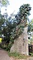
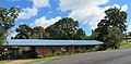
Coondoo Street is the main street in Kuranda. It has many shops, art galleries, and old, shady trees. St. Saviour's Anglican Church on Coondoo Street is famous for its colorful glass windows. The gardens around St Christopher's Catholic Church and the Seventh Day Adventist Church are great for spotting tropical birds. You can also find a Japanese plane wreck hidden in the bushes near Therwine Street.
Kuranda Koala Garden
The Kuranda Koala Garden is a small wildlife park. Here you can see many Australian animals. These include koalas, wombats, kangaroos, wallabies, and many other native creatures like possums, lizards, and pythons.
Images for kids
-
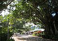
Coondoo Street, the main street in Kuranda.
-
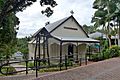
St. Saviour's Church, known for its colorful windows.
-
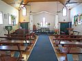
Another view of St. Saviour's Church.
-
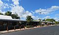
Therwine Street in the town center.
-
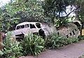
A Japanese plane wreck in the bushes.
-
Another view of the Japanese plane wreck.
-
The Adventist Church in Kuranda.


