
Nandewar Range facts for kids
Quick facts for kids Nandewar Range |
|
|---|---|

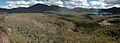
Mount Kaputar, the third peak from the left, is the range's highest peak.
|
|
| Highest point | |
| Peak | Mount Kaputar |
| Elevation | 1,508 m (4,948 ft) |
| Geography | |

Location in New South Wales
|
|
| Country | Australia |
| State | New South Wales |
| Range coordinates | 30°30′S 151°00′E / 30.5°S 151°E |
| Geology | |
| Age of rock | Cenozoic |
| Type of rock | Shield volcano |
The Nandewar Range is a group of mountains in New South Wales, Australia. It's part of the much larger Great Dividing Range. You can find it in the Northern Tablelands area, about 30 kilometers (19 miles) east of a town called Narrabri.
An explorer named John Oxley was the first European to see these mountains in 1818. He was exploring New South Wales at the time.
Contents
Exploring the Nandewar Range
The Nandewar Range is on the western side of the New England region. It acts like a natural wall, separating the water that flows into the Namoi River in the south from the water that flows into the Gwydir River in the north. This means rain falling on one side goes to the Namoi, and rain on the other side goes to the Gwydir.
The eastern part of the Nandewar Range begins near Uralla. A main road that connects Barraba and Bingara crosses over these mountains.
Mount Kaputar: A Volcanic Wonder
At the western end of the range, you'll find Mount Kaputar. This mountain is actually a complex of old volcanoes! From its top, you can see amazing views of the flat plains of New South Wales stretching out below.

The lower areas around the Nandewar Range are used for farming, like grazing animals and growing crops. Higher up, there are forests. A big part of the Mount Kaputar area is protected as Mount Kaputar National Park. Sometimes, in winter, the mountains get a light dusting of snow, which looks beautiful!
How the Nandewar Range Formed
The Nandewar Range is what's left of a huge, old shield volcano. Imagine a volcano that's wide and flat, like a warrior's shield – that's a shield volcano! This one formed about 18 million years ago. Over millions of years, wind and rain have worn it down, leaving behind the mountains we see today. Some of the rocks you can find here are incredibly old, around 230 million years old!
The Meaning Behind the Names
Many of the names in the Nandewar Range come from the local Gamilaraay language. For example, 'Nandewar' itself, 'Kaputar', and 'Ninghdoo' (which is pronounced Ningy-doo or Nungadhun) are all Gamilaraay names for these important places. Ninghdoo is a special type of rock formation called a volcanic plug.
Important Peaks of the Range
The Nandewar Range has several notable mountains. Here are some of them:
- Bushy Mountain, which is about 1,260 meters (4,134 feet) high.
- Castletop Mountain
- Gins Mountain
- Grattai Mountain, standing at about 1,301 meters (4,268 feet) tall.
- Mount Dowe, reaching about 1,457 meters (4,780 feet).
- Mount Kaputar, the highest peak, at about 1,489 meters (4,885 feet).
- Mount Lawler
- Mount Lindesay, around 1,373 meters (4,505 feet) high.
- Mount Ningadhun, about 1,013 meters (3,323 feet) tall.
- Mount Waa
- Mount Yulludunida
- Round Mountain
Images for kids
-
Grattai Mountain rises to 1,301 meters (4,268 feet) and is the most northerly peak in the range.
