
National Register of Historic Places listings in Harford County, Maryland facts for kids

Harford County, Maryland, is a place filled with amazing history! Imagine buildings, areas, and even old boats that are so special, they've been officially recognized as important parts of America's past. These special spots are listed on something called the National Register of Historic Places. It's like a national hall of fame for historic sites!
There are 79 of these cool places in Harford County. One of them, called Sion Hill, is extra special because it's also a National Historic Landmark. That means it's super important to the whole country's history!
Contents
What is the National Register of Historic Places?
The National Register of Historic Places is an official list kept by the United States government. It helps protect places that are important to American history, architecture, archaeology, engineering, or culture. When a place is on this list, it means it's worth saving for future generations to learn from and enjoy.
Discovering Harford County's Historic Treasures
Let's take a look at some of the fascinating historic places you can find in Harford County. Each one tells a unique story about the past!
Historic Homes and Buildings
Many old houses and buildings in Harford County have incredible stories. They show us how people lived long ago and what kind of architecture was popular.
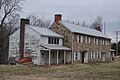
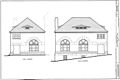
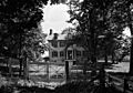
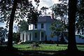
- James B. Baker House: Located in Aberdeen, this house was listed in 1982.
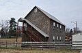
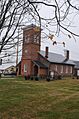
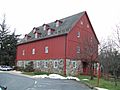
- Bel Air Armory: Found in Bel Air, this armory was added to the list in 1985.
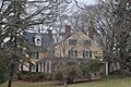
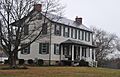
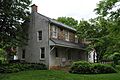
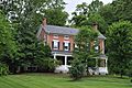
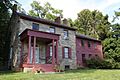
- Best Endeavor: This historic home in Churchville joined the list in 1990.
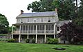
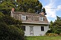
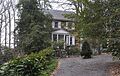
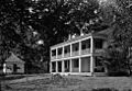
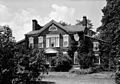
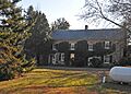
- Bon Air: A beautiful spot in Fallston, listed in 1977.
- Broom's Bloom: You can find this historic place in Bel Air, listed in 1991.
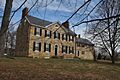
- Chestnut Ridge: Another historic site in Aberdeen, added in 1983.
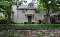
- Dibb House: East of Bel Air, this house was listed in 1980.
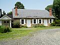
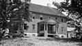
- Fair Meadows: Located in Creswell, this property was added in 1980.
- Gladden Farm: This farm in Street became historic in 1993.
- Graham-Crocker House: In Bel Air, listed in 1980.
- Gray Gables: A historic home in Darlington, added in 1986.
- Graystone Lodge: Found in Bel Air, listed in 2007.
- Griffith House: Southwest of Aberdeen, this house was added in 1978.
- Hays House: In Bel Air, listed in 1980.
- Hays-Heighe House: Another historic house in Bel Air, added in 1972.
- Hidden Valley Farm: This farm in Baldwin was listed in 1983.
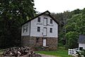
- Ivory Mills: Located in White Hall, this mill was added in 1997.
- Joshua's Meadows: In Bel Air, listed in 1982.
- Liriodendron: This unique place in Bel Air was added in 1980.
- McComas Institute: North of Joppa, listed in 1980.
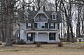
- Mount Adams: In Bel Air, this site was added in 1988.
- Nelson-Reardon-Kennard House: Found in Abingdon, listed in 1991.
- Norris-Stirling House: In Bel Air, added in 1979.
- Odd Fellows Lodge: This lodge in Bel Air was listed in 1975.
- Olney: Located in Joppa, this property was added in 1987.
- Poplar Hill: In Aberdeen, listed in 1976.
- Proctor House: Another historic house in Bel Air, added in 1990.
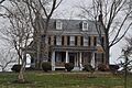
- Rigbie House: Southeast of Berkley, listed in 1973.
- Rockdale: North of Fallston, this property was added in 1982.
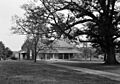
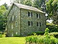
- Sophia's Dairy: Southwest of Aberdeen, listed in 1973.
- Col. John Streett House: East of Deer Creek in Street, added in 1990.
- Swansbury: Northeast of Aberdeen, listed in 1994.
- Tudor Hall: Northeast of Bel Air, added in 1973.
- The Vineyard: In Bel Air, listed in 1994.
- Webster's Forest: Located in Churchville, this site was added in 1983.
- Wildfell: Northwest of Darlington, listed in 1973.
- Winsted: North of Aberdeen, added in 1979.
- Woodside: Northwest of Abingdon, listed in 1979.
- Woodview: In Bel Air, this property was added in 1990.
Historic Districts and Villages
Sometimes, a whole area or group of buildings is historic! These are called historic districts. They show how communities grew and changed over time.
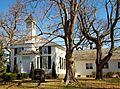
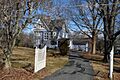
- Bel Air Courthouse Historic District: This area in Bel Air was listed in 1985.
- Berkley Crossroads Historic District: Found in Darlington, this district was added in 2003.
- Darlington Historic District: The main streets of Darlington became a historic district in 1987.
- Finney Houses Historic District: Near Churchville, this district was listed in 1989.
- Harford Furnace Historic District: In Bel Air, added in 1990.
- Havre de Grace Historic District: A large historic area in Havre de Grace, listed in 1982.
- Heighe House: This district in Bel Air was added in 1990.
- Jerusalem Mill Village: A historic village in Jerusalem, listed in 1987.
- Lower Deer Creek Valley Historic District: This valley area near Darlington was added in 1993.
- Medical Hall Historic District: West of Churchville, listed in 1973.
- Mill Green Historic District: In Street, this district was added in 1993.
- My Lady's Manor: A historic area in Jarrettsville, listed in 1978.
- Old Joppa Site: This historic site in Joppatowne was added in 1979.
- Silver Houses Historic District: South of Darlington, listed in 1984.
- Southern Terminal, Susquehanna and Tidewater Canal: In Havre de Grace, added in 1976.
- Whitaker's Mill Historic District: Located in Joppa, this district was listed in 1990.
- Whiteford-Cardiff Historic District: This district is split between Maryland and Pennsylvania, listed in 2005.
Historic Churches and Meetinghouses
Many old churches and meetinghouses are important because of their history and unique architecture. They show us how communities worshipped and gathered.
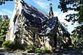
- Church of the Holy Trinity: In Churchville, this church was listed in 2002.
- Churchville Presbyterian Church: Another church in Churchville, added in 1986.
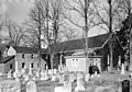
- Deer Creek Friends Meetinghouse: In Darlington, listed in 1980.
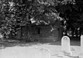
- Gunpowder Meetinghouse: Located at Aberdeen Proving Ground, this meetinghouse was added in 1974.
- Little Falls Meetinghouse: In Fallston, listed in 1980.
- Presbury Meetinghouse: Also at Aberdeen Proving Ground, added in 1974.
- Priest Neal's Mass House and Mill Site: In Bel Air, listed in 1990.
- St. George's Parish Vestry House: In Perryman, added in 1976.
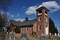
- St. Ignatius Church: Located in Forest Hill, this church was listed in 1974.
- St. Mary's Church: South of Emmorton, added in 1973.
- Thomas Run Church: Northeast of Bel Air, listed in 1978.
Other Unique Historic Sites
Harford County also has other interesting historic places, like lighthouses, schools, and even old quarries!
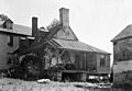
- Broad Creek Soapstone Quarries: These ancient quarries near Whiteford were listed in 1975.
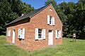
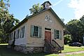
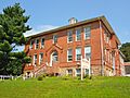
- Berkley School: This old school in Darlington was added in 1988.
- Concord Point Light: Also known as Havre de Grace Lighthouse, this lighthouse in Havre de Grace was listed in 1976.
- Husband Flint Mill Site: This mill site near Kalmia was added in 1975.
- Jericho Covered Bridge: East of Jerusalem, this historic bridge was listed in 1978.
- Ladew Topiary Gardens and House: In Taylor, this amazing garden with sculpted bushes and historic house was added in 1976. It's a 250-acre estate!
- Martha Lewis (skipjack): This historic boat, a Chesapeake Bay skipjack, is located in Havre de Grace and was listed in 2008.
- Pooles Island Lighthouse: This lighthouse on Poole's Island near Edgewood was added in 1997.
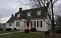
- Sion Hill: This is the special National Historic Landmark in Havre de Grace, listed in 1990. It was once the home of important U.S. Navy officers.
- Slate Ridge School: An old school in Whiteford, listed in 1987.
Template:NRHP footer
Images for kids
-
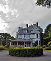
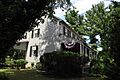
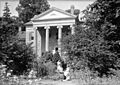
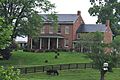
The James B. Baker House.
-
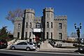
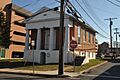
The Bel Air Armory.
-
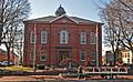
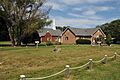
The Bel Air Courthouse Historic District.
-
The Berkley Crossroads Historic District.
-
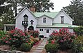
The Berkley School.
-
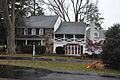
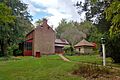
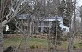
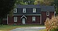
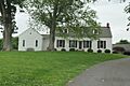
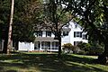
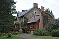
Best Endeavor.
-
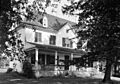
Bon Air.
-

Image for Broad Creek Soapstone Quarries (address restricted).
-
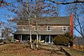
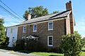
Broom's Bloom.
-
Chestnut Ridge.
-
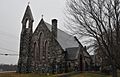
The Church of the Holy Trinity.
-
Churchville Presbyterian Church.
-
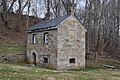
The D. H. Springhouse.
-
Darlington Historic District.
-
Deer Creek Friends Meetinghouse.
-
The Dibb House.
-
Fair Meadows.
-
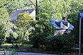
Finney Houses Historic District.
-
Gladden Farm.
-
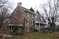
The Graham-Crocker House.
-
Gray Gables.
-
Graystone Lodge.
-
The Griffith House.
-
Gunpowder Meetinghouse.
-
Harford Furnace Historic District.
-
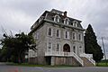
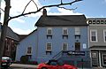
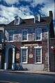
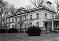
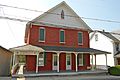
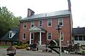
Harford National Bank.
-
Havre de Grace Historic District.
-
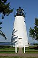
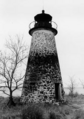
Havre de Grace Lighthouse.
-
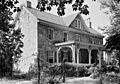
The Hays House.
-
The Hays-Heighe House.
-
Heighe House.
-
Hidden Valley Farm.
-
Image for Husband Flint Mill Site (address restricted).
-
Ivory Mills.
-
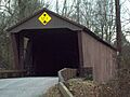
Jericho Covered Bridge.
-
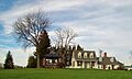
Jerusalem Mill Village.
-
Joshua's Meadows.
-
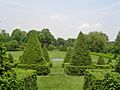
Ladew Topiary Gardens.
-
Liriodendron.
-
Little Falls Meetinghouse.
-
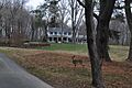
Lower Deer Creek Valley Historic District.
-
McComas Institute.
-
Medical Hall.
-
Mill Green Historic District.
-
Mount Adams.
-
My Lady's Manor.
-
Nelson-Reardon-Kennard House.
-
Norris-Stirling House.
-
Odd Fellows Lodge.
-
Old Joppa Site.
-
Olney.
-
Pooles Island Lighthouse.
-
Poplar Hill.
-
Presbury Meetinghouse.
-
Priest Neal's Mass House and Mill Site.
-
Proctor House.
-
Rigbie House.
-
Rockdale.
-
St. George's Parish Vestry House.
-
St. Ignatius Church.
-
St. Mary's Church.
-
Silver Houses Historic District.
-
Sion Hill.
-
Slate Ridge School.
-
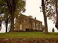
Sophia's Dairy.
-
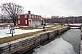
Southern Terminal, Susquehanna and Tidewater Canal.
-
Col. John Streett House.
-
Swansbury.
-
Thomas Run Church.
-
Tudor Hall.
-
The Vineyard.
-
Webster's Forest.
-
Whitaker's Mill Historic District.
-
Whiteford-Cardiff Historic District.
-
Wildfell.
-
Winsted.
-
Woodside.
-
Woodview.


_-_Harford_National_Bank,_Bel_Air,_Harford_County,_MD.jpg)


_Left_Side.JPG)


