
National Register of Historic Places listings in Huntington (town), New York facts for kids
The Town of Huntington in New York is home to many amazing places that are part of something called the National Register of Historic Places. This is a special list kept by the United States government to recognize buildings, sites, and objects that are important to history. When a place is on this list, it means it's worth protecting and learning about!
These historic spots in Huntington tell us stories about the past, from old homes and churches to lighthouses and even a famous jazz musician's house. They help us understand how people lived long ago and what events shaped the area. You can even see where some of these places are on an online map if you know their exact location!
Contents
- Historic Homes and Estates
- Bay Crest Historic District
- M. Baylis House
- Beaux Arts Park Historic District
- Bowes House
- George McKesson Brown Estate-Coindre Hall
- Buffett Houses
- Carll S. Burr Mansion
- Ezra Carll Homestead
- Marion Carll Farm
- Chichester's Inn
- David Conklin House
- Delamater-Bevin Mansion
- Harry E. Donnell House
- Marshall Field, III, Estate
- Gilsey Mansion
- Jarvis-Fleet House
- John P. Kane Mansion
- Joseph Lloyd House
- Oheka Castle
- Prime-Octagon House
- Silas Sammis House
- Suydam House
- William K. Vanderbilt Estate-Eagles Nest
- Walt Whitman House
- Historic Public Buildings and Sites
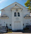
- Bethel AME Church and Manse
- Cold Spring Harbor Fire District Hook and Ladder Company Building
- Cold Spring Harbor Library
- Commack Methodist Church and Cemetery
- Fort Golgotha and the Old Burial Hill Cemetery
- Long Island National Cemetery
- Northport Public Library
- Northport Veterans Administration Hospital Historic District
- Old First Church
- Old Town Hall Historic District
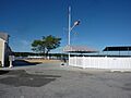
- US Post Office-Northport
- Other Notable Historic Places
- Historic Districts
- Images for kids
Historic Homes and Estates
Huntington has many old houses and grand estates that have been saved because of their history.
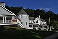
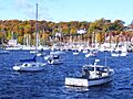
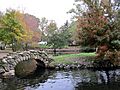
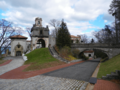
Bay Crest Historic District
The Bay Crest Historic District is a special area in Huntington Bay. It includes several streets like Beech Avenue and Valley Road. This district is recognized for its unique collection of homes and how the neighborhood was planned.

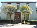
M. Baylis House
The M. Baylis House is located at 530 Sweet Hollow Road in Melville. It's an important historic home that was added to the National Register in 1985.
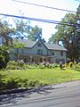
Beaux Arts Park Historic District
Another historic district in Huntington Bay is the Beaux Arts Park Historic District. It covers Locust Lane and Upper & Lower Drives. This area is known for its beautiful architecture and design style from the Beaux-Arts period.

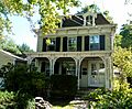
Bowes House
The Bowes House is a historic home found at 15 Harbor Hill Drive in Huntington Bay. It's another example of the important older buildings in the area.
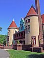
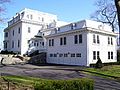
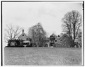
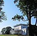
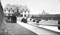
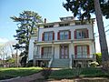
George McKesson Brown Estate-Coindre Hall
Coindre Hall is a grand estate located on Brown's Road in Huntington. It was once the home of George McKesson Brown and is a stunning example of historic architecture.

Buffett Houses
There are two historic homes belonging to the Buffett family:
- Eliphas Buffett House: This house is at 159 West Rogues Path in Cold Spring Harbor.

- Joseph Buffett House: Right nearby, at 169 West Rogues Path, is the Joseph Buffett House. Both were added to the list in 1985.

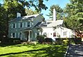
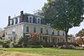
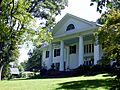
Carll S. Burr Mansion
The Carll S. Burr Mansion is a historic house built in 1830 in Commack. It's a beautiful example of a Second Empire style mansion.

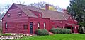
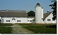
Ezra Carll Homestead
The Ezra Carll Homestead is an old farm located at 49 Melville Road in South Huntington. It shows us what farm life was like in the past.
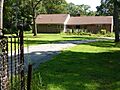
Marion Carll Farm
The Marion Carll Farm, at 475 Commack Road in Commack, is another important historic farm. It was added to the National Register in 1979.

Chichester's Inn
Chichester's Inn, at 97 Chichester Road in West Hills, is a very old building from the 17th century. Famous people like Walt Whitman and Theodore Roosevelt visited this inn at different times! Today, it's a house.

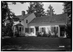
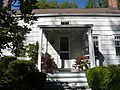
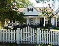
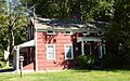
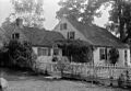
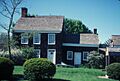
David Conklin House
The David Conklin House, located at 2 High Street in Huntington, is a historic home that gives us a glimpse into the past.

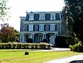
Delamater-Bevin Mansion
The Delamater-Bevin Mansion is a beautiful old house on Bevin Lane in Asharoken. It's a great example of historic architecture in the area.

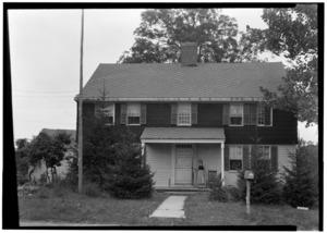
Harry E. Donnell House
You can find the Harry E. Donnell House at 71 Locust Lane in Eatons Neck. This house is another one of Huntington's many historic treasures.

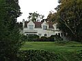
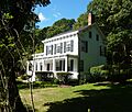
Marshall Field, III, Estate
The Marshall Field, III, Estate is a large property on Lloyd Harbor Road in Lloyd Harbor. It's a significant historic estate that is now part of Caumsett State Historic Park Preserve.

Gilsey Mansion
The Gilsey Mansion, at 36 Browns Road in Huntington, is a historic building that adds to the rich history of the town.

Jarvis-Fleet House
The Jarvis-Fleet House is located at 138 Cove Road in Huntington. It's a well-preserved historic home.

John P. Kane Mansion
The John P. Kane Mansion, also known as "High Lindens," is at 37 Kanes Lane in Huntington Bay. It's a grand historic home.

Joseph Lloyd House
The Joseph Lloyd House is northwest of Huntington on Lloyd Harbor Road in Lloyd Harbor. It's a very important historic house that tells us about early life in the area.

Oheka Castle
Oheka Castle, at 135 West Gate Drive in Cold Springs Hills, is one of the most famous and largest historic estates in the United States. It's a truly magnificent castle-like mansion!

Prime-Octagon House
The Prime-Octagon House, at 41 Prime Avenue in Huntington, is special because of its unique eight-sided shape. Octagon houses were a popular, but unusual, style in the mid-1800s.

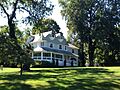
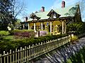
Silas Sammis House
The Silas Sammis House is located at 302 West Neck Road in Huntington. It's a historic home that has been preserved for its architectural and historical value.
Suydam House
The Suydam House, at 1 Fort Salonga Road in Centerport, is another significant historic home in the region.

William K. Vanderbilt Estate-Eagles Nest
The William K. Vanderbilt Estate, also known as "Eagles Nest," is on Little Neck Road in Centerport. This grand estate was once the home of William K. Vanderbilt II and now houses the Vanderbilt Museum.

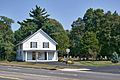
Walt Whitman House
The Walt Whitman House, at 246 Old Walt Whitman Road in West Hills, is the birthplace of the famous American poet Walt Whitman. It's a very important literary landmark.

Historic Public Buildings and Sites
Beyond homes, Huntington also has historic public buildings and important sites.
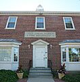
Bethel AME Church and Manse
The Bethel AME Church and Manse (the minister's house) are located at 291 Park Avenue in Huntington. This church has a rich history and is an important part of the community.

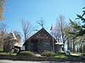
Cold Spring Harbor Fire District Hook and Ladder Company Building
This historic fire station, on Main Street at Elm Place in Cold Spring Harbor, was built for the local fire department. It's a cool example of an old community building.

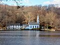
Cold Spring Harbor Library
The Cold Spring Harbor Library, at 1 Shore Road in Cold Spring Harbor, is a historic building that has served the community for many years as a place for learning and reading.
_(2).jpg)
Commack Methodist Church and Cemetery
The Commack Methodist Church and its cemetery, at 486 Townline Road in Commack, are historic sites that tell us about the religious and community life of the past.

Fort Golgotha and the Old Burial Hill Cemetery
Located at Main Street and Nassau Road in Huntington, this site includes an old fort and a cemetery. It played a role in history and is a place to remember those who came before us.

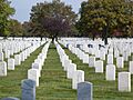
Long Island National Cemetery
The Long Island National Cemetery, at 2040 Wellwood Avenue in Melville, is a special place where veterans are buried. It was built in the 1930s and expanded to honor many World War II veterans and prisoners of war.

Northport Public Library
The Northport Public Library, at 215 Main Street in Northport, is a historic building that has been a center for knowledge and community for a long time.

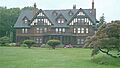
Northport Veterans Administration Hospital Historic District
This historic district, at 79 Middleville Road in East Northport, is part of a larger group of historic veterans' hospitals across the country. It shows how medical care for veterans has evolved.

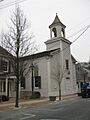
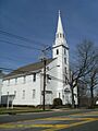
Old First Church
The Old First Church, at 126 Main Street in Huntington, is a very old and important church building. It has been a central part of Huntington's history for many years.

Old Town Hall Historic District
This historic district, located around Main Street and Nassau Road in Huntington, includes the old town hall. It's where important decisions for the town were made long ago.

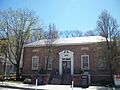
US Post Office-Northport
The US Post Office in Northport, at 244 Main Street, is a historic building that has served as the local post office for many years.

Other Notable Historic Places
Huntington also has other interesting historic places, like lighthouses and parks.
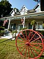
Cold Spring Harbor Beach Club
The Cold Spring Harbor Beach Club, at 101 Shore Road in Cold Spring Harbor, is a historic recreational spot.

John Coltrane Home
The John Coltrane Home, at 247 Candlewood Path in Dix Hills, was the home of the legendary jazz musician John Coltrane. It's a significant site for music history.

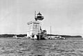
Eatons Neck Light
The Eatons Neck Light is a lighthouse located at Eatons Neck Point, where Huntington Bay meets the Long Island Sound. Lighthouses are important for guiding ships safely.

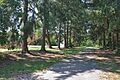
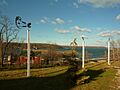
Heckscher Park
Heckscher Park in Huntington is a historic park bounded by Madison Street, Sabbath Day Path, Main Street, and Prime Avenue. It's a beautiful green space that has been enjoyed by the community for generations.

Lloyd Harbor Lighthouse
The Lloyd Harbor Lighthouse is located at the entrance to Lloyd Harbor. Like Eatons Neck Light, it's a historic beacon that helped guide boats.

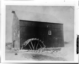
Van Wyck-Lefferts Tide Mill
The Van Wyck-Lefferts Tide Mill, located northeast of Mill and Southdown Roads in Lloyd Harbor, is a historic tide mill. Tide mills use the power of the tides to grind grain, which was an important technology long ago.
Historic Districts
Some areas are recognized as Historic Districts because they have many historic buildings that together create a special sense of the past.
East Shore Road Historic District
The East Shore Road Historic District in Halesite is an area recognized for its collection of historic buildings along East Shore Road.

Harbor Road Historic District
The Harbor Road Historic District in Cold Spring Harbor is another area with many historic buildings along Harbor Road.

Main Street Historic District (Cold Spring Harbor, New York)
The Main Street Historic District in Cold Spring Harbor includes many historic buildings along Main Street. It's a charming area that looks much like it did in the past.

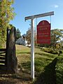
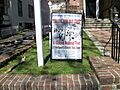
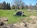
Old Town Green Historic District
The Old Town Green Historic District in Huntington is centered around Park Avenue. This area has been important to the town for centuries.

Shore Road Historic District
The Shore Road Historic District in Cold Spring Harbor is another area with many historic buildings along Shore Road.

West Neck Road Historic District
The West Neck Road Historic District in Huntington is an area with many historic buildings along West Neck Road.

Images for kids
-
A view of the Bay Crest Historic District.
-
A street in the Beaux Arts Park Historic District.
-
Bethel AME Church and Manse.
-
Coindre Hall, a historic estate in Huntington.
-
The Eliphas Buffett House.
-
The Joseph Buffett House.
-
The Carll S. Burr Mansion.
-

The Ezra Carll Homestead.
-
The entrance to Marion Carll Farm.
-
Chichester's Inn, a historic spot visited by famous figures.
-
The Cold Spring Harbor Beach Club.
-
The Cold Spring Harbor Fire District Hook and Ladder Company Building.
-
The Cold Spring Harbor Library.
-
The John Coltrane Home.
-
The Commack Methodist Church.
-

The David Conklin House and its barn.
-
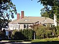
The Charles Homer Davis House.
-
The Delamater-Bevin Mansion.
-
The Harry E. Donnell House.
-
The Dowden Tannery.
-
East Shore Road Historic District.
-
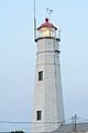
The Eatons Neck Lighthouse.
-
Part of the Marshall Field, III, Estate, now Caumsett State Park.
-
Fort Golgotha and the Soldiers and Sailors Memorial Building.
-
The Fort Hill Estate.
-
The Gilsey Mansion.
-
Harbor Road Historic District.
-
Heckscher Park in Huntington.
-
The Jarvis-Fleet House.
-
The John P. Kane Mansion.
-
The A. P. W. Kennan House.
-
The Lloyd Harbor Lighthouse.
-
The Joseph Lloyd House.
-
The Long Island National Cemetery.
-
The Isaac Losee House.
-
A building in the Main Street Historic District, Cold Spring Harbor.
-
The Northport Public Library.
-
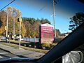
Sign for the VA Medical Center in Northport.
-
Oheka Castle, a grand historic estate.
-
The Old First Church in Huntington.
-
A historical marker in the Old Town Green Historic District.
-

The Old Huntington Town Hall.
-

The Prime House.
-

The unique Prime-Octagon House.
-
The Rogers House.
-

The Silas Sammis House.
-
Shore Road Historic District.
-
The Suydam House.
-
The Titus-Bunce House.
-
The Henry Townsend House.
-
The Northport Post Office.
-

The Van Wyck-Lefferts Tide Mill.
-
The William K. Vanderbilt Estate, now the Vanderbilt Museum.
-
The Charles M. Weeks House.
-
West Neck Road Historic District.
-
The birthplace of poet Walt Whitman.
-
The Charles Woodhull House.


.JPG)
