Huntington (CDP), New York facts for kids
Quick facts for kids
Huntington, New York
|
|
|---|---|

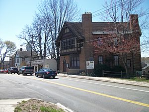
The historic former Huntington Sewing & Trade School, now the headquarters of the Huntington Historical Society.
|
|
| Nickname(s):
"Huntington Village"; "Downtown Huntington"
|
|

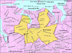
U.S. Census map of Huntington
|
|
| Country | United States |
| State | |
| County | Suffolk |
| Town | Huntington |
| Area | |
| • Total | 7.79 sq mi (20.18 km2) |
| • Land | 7.64 sq mi (19.79 km2) |
| • Water | 0.15 sq mi (0.39 km2) |
| Elevation | 75 ft (23 m) |
| Population
(2020)
|
|
| • Total | 19,645 |
| • Density | 2,571.34/sq mi (992.82/km2) |
| Demonym(s) | Huntingtonian |
| Time zone | UTC-5 (EST) |
| • Summer (DST) | UTC-4 (EDT) |
| ZIP code |
11743
|
| Area code(s) | 631, 934 |
| FIPS code | 36-36233 |
| GNIS feature ID | 0953488 |
Huntington is a cool place on Long Island, in New York. It's a type of community called a hamlet. It's also a census-designated place (CDP), which means it's an area defined for counting people. Huntington is the main town center for the larger Town of Huntington.
The population of Huntington was 19,645 people in 2020. The main part of the hamlet is known as Huntington Village or "Downtown Huntington." It's a busy area with lots of shops and places to go. Even though it's a big, developed area, it doesn't have its own separate village government.
Contents
Geography of Huntington
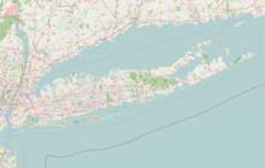
Huntington is located in Suffolk County. It's on the North Shore of Long Island. This means it's close to the water.
Size and Location
The total area of Huntington is about 7.7 square miles (19.9 square kilometers). Most of this area is land. Only a small part, about 0.1 square miles (0.4 square kilometers), is water.
Huntington is about 37 miles (59 kilometers) northeast of Midtown Manhattan. That's the busy central part of New York City.
Communities in the Huntington Area
The larger Town of Huntington includes several different communities. These include two villages and nine hamlets.
Here are some of the communities in the greater Huntington area:
- Huntington (the hamlet this article is about)
- Huntington Bay
- Huntington Station
- South Huntington
- Cold Spring Harbor
- Lloyd Harbor
- Halesite
- Elwood
- Greenlawn
- Centerport
Population Facts
| Historical population | |||
|---|---|---|---|
| Census | Pop. | %± | |
| 2000 | 18,403 | — | |
| 2010 | 18,406 | 0.0% | |
| 2020 | 19,645 | 6.7% | |
| U.S. Decennial Census | |||
In 2020, Huntington had a population of 19,645 people. Back in 2000, there were 18,403 people living here. The population has grown a bit over the years.
Most households in Huntington are families. About 31.7% of households have kids under 18 living with them. The average household has about 2.59 people.
The median age in Huntington is 40 years old. This means half the people are younger than 40, and half are older. About 23.1% of the population is under 18 years old.
Education in Huntington
Students in Huntington go to public schools in one of three different school districts. Which district they attend depends on where they live within the hamlet.
The school districts that serve Huntington are:
- Cold Spring Harbor Central School District
- Harborfields Central School District
- Huntington Union Free School District
Getting Around Huntington
The main village area of Huntington is easy to walk around. There are also several bus routes that serve the area.
Bus Services
- The Route 1 bus is part of Suffolk County Transit. It travels along Route 110. This route connects Halesite to Amityville.
- The H10, H20, and H30 buses are run by Huntington Area Rapid Transit. These buses serve different parts of the village.
Train Connections
The Route 1, H10, and H20 buses all connect to the Long Island Rail Road (LIRR). The LIRR station is called Huntington station. This station is actually located in the nearby hamlet of Huntington Station.
See also
 In Spanish: Huntington (condado de Suffolk) para niños
 | Mary Eliza Mahoney |
 | Susie King Taylor |
 | Ida Gray |
 | Eliza Ann Grier |


