
National Register of Historic Places listings in Windsor, Connecticut facts for kids

Welcome to Windsor, Connecticut! This town is home to many amazing old buildings and areas that are super important to American history. These special places are listed on the National Register of Historic Places. Think of it like a Hall of Fame for historic buildings and neighborhoods across the United States!
In Windsor, there are 41 different places that have earned a spot on this important list. One of them is even a National Historic Landmark, which is an even higher honor! These places help us remember and learn about the past. You can even find many of them on online maps if you want to see where they are!
|
Fairfield (city of Bridgeport) (town of Greenwich) (city of Stamford) | Hartford (city of Hartford) (town of Southington) (town of West Hartford) (town of Windsor) | Litchfield | Middlesex (city of Middletown) | New Haven (city of New Haven) | New London | Tolland | Windham |
What is the National Register of Historic Places?
The National Register of Historic Places is the official list of places in the United States that are worth saving. These can be buildings, sites, structures, objects, or even entire neighborhoods. They are chosen because they are important to American history, architecture, archaeology, engineering, or culture.
When a place is listed, it means it's recognized for its special value. It helps people understand why these places matter and encourages their protection. It's like giving a medal to a building for being a historical superstar!
Meet Windsor's Historic Treasures
Windsor has many cool historic spots. Let's look at some of them and what makes them special.
Homes with History
Many of the places on the list are old houses. These homes tell us stories about the people who lived in Windsor long ago.
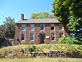
Capt. Benjamin Allyn II House
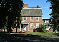
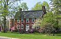
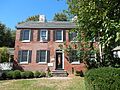
The Capt. Benjamin Allyn II House, located at 119 Deerfield Road, was added to the list in 1979. Imagine living in a house that's been around for so many years!
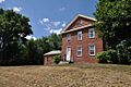
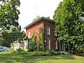
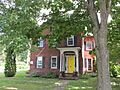
Giles Barber House
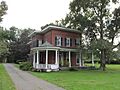
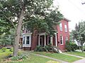
The Giles Barber House at 411-413 Windsor Avenue joined the Register in 1988. It's a great example of the kind of homes people built back then.
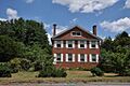
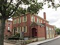
Bissell Tavern-Bissell's Stage House
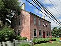
At 1022 Palisado Avenue, you'll find the Bissell Tavern-Bissell's Stage House. Listed in 1985, this building was likely a busy spot where travelers could rest and eat when stagecoaches were the main way to travel.
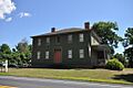
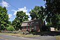
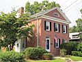
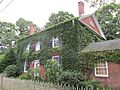
Hezekiah Chaffee House
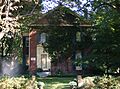
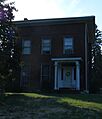
The Hezekiah Chaffee House, found off Palisado Green, has been on the list since 1972. It's one of the older listings in Windsor, showing its early recognition as an important historical site.
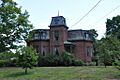
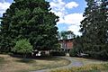
Oliver Ellsworth Homestead: A National Landmark

One of Windsor's most famous historic places is the Oliver Ellsworth Homestead at 778 Palisado Avenue. This house is super special because it's a National Historic Landmark! It was the home of Oliver Ellsworth, who was the third Chief Justice of the United States. A Chief Justice is the main judge of the highest court in the country, the Supreme Court. He was a very important person in early American history, helping to shape the laws of our nation. This house was recognized in 1970.
Historic Districts: Whole Neighborhoods of History
Sometimes, it's not just one building that's historic, but a whole area! These are called historic districts.
Broad Street Green Historic District
The Broad Street Green Historic District, listed in 1999, covers the area around Broad Street. Historic districts often have many old buildings that together create a special historical feeling. It's like stepping back in time when you walk through them!

Palisado Avenue Historic District
Another important area is the Palisado Avenue Historic District, added in 1987. This district includes many buildings along Palisado Avenue, which is also Connecticut Route 159. It stretches between the Farmington River and Bissell Ferry Road. This area is full of old homes and buildings that show how Windsor grew over the years.

Other Notable Historic Places
Windsor's history isn't just about homes. There are other types of buildings that played important roles in the town's past.
Farmington River Railroad Bridge

The Farmington River Railroad Bridge, listed in 1972, is a cool example of old engineering. This bridge spans the Farmington River and Pleasant Street. It reminds us of the early days of railroads, which were vital for travel and moving goods.
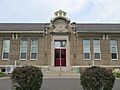
John Fitch School
The John Fitch School at 156 Bloomfield Avenue was added to the Register in 1986. Schools are often important community buildings, and this one has a long history of educating Windsor's children.
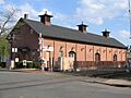
Hartford & New Haven Railroad Depot

The Hartford & New Haven Railroad Depot on Central Street, listed in 1988, was once a busy train station. Imagine people arriving and departing from here, traveling to and from Windsor by train! There's also a separate freight depot nearby at 40 Central Street, also listed in 1988, which was used for shipping goods.
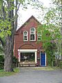
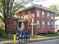
Former Fire Station
The Former Fire Station at 14 Maple Avenue, listed in 1988, reminds us of how communities protected themselves from fires long ago. It's a piece of local public service history.
Stony Hill School
Another old school building, the Stony Hill School at 1195 Windsor Avenue, was listed in 1988. It's another example of a community building that served generations of students.
Why are these places important?
These historic places in Windsor are like living textbooks. They help us understand what life was like in the past, how people lived, worked, and built their communities. By preserving them, we make sure that future generations can also learn from and appreciate Windsor's rich history. They are a link to the past, helping us understand where we come from and how our town became what it is today.
Images for kids
-
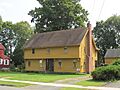
The Capt. Benjamin Allyn II House.
-
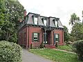
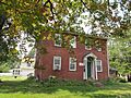
The Giles Barber House.
-
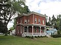
The Bissell Tavern-Bissell's Stage House.
-
The Benomi Case House.
-
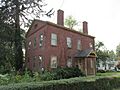
The Hezekiah Chaffee House.
-
The Taylor Chapman House.
-
The Horace H. Ellsworth House.
-
The First Church Parsonage.
-
The John Fitch School.
-
The Former Fire Station.
-
The Grace Church Rectory.
-
The Hartford & New Haven Railroad-Freight Depot.
-
The William H. Harvey House.
-
Hathaways Store.
-
The Capt. Nathaniel Hayden House.
-
The House at 111 Maple Avenue.
-
The House at 130 Hayden Station Road.
-
The House at 44 Court Street.
-
The House at 736 Palisado Avenue.
-
The Capt. James Loomis House.
-
The Col. James Loomis House.
-
The George G. Loomis House.
-
The Gordon Loomis House.
-
The Ira Loomis, Jr. House.
-
The Henry Magill House.
-
The Elijah Mills House.
-
The Oliver W. Mills House.
-
The Timothy Dwight Mills House.
-
The Deacon John Moore House.
-
The Edward and Ann Moore House.
-
The Patrick Murphy House.
-
The Daniel Payne House.
-
The Eli Phelps House.
-
The William Shelton House.
-
The Sophia Sweetland House.


