
National Register of Historic Places listings in Southington, Connecticut facts for kids

Have you ever wondered about the old buildings and special places around you? Some of these places are so important that they are listed on the National Register of Historic Places. This is a special list in the United States that helps protect and celebrate historic buildings, sites, and districts.
In Southington, there are many amazing historic spots! This article will tell you about the cool places in Southington that are on this important list.
What is the National Register of Historic Places?
The National Register of Historic Places is like a Hall of Fame for historic places in America. It's managed by the National Park Service. When a place is added to this list, it means it's special because of its history, architecture, or what happened there.
Being on the list helps protect these places. It also makes people more aware of their history. In Hartford County, where Southington is located, there are over 400 places on this list! Southington itself has 41 of these amazing historic properties and areas.
Some places, like the Farmington Canal-New Haven and Northampton Canal, Hubbard Park, and the Marion Historic District, are so big they stretch into other towns too!
Many old houses in Southington were studied together in 1988 to see if they should be on the list. These houses are marked with a star (*) in the list below.
|
Fairfield (city of Bridgeport) (town of Greenwich) (city of Stamford) | Hartford (city of Hartford) (town of Southington) (town of West Hartford) (town of Windsor) | Litchfield | Middlesex (city of Middletown) | New Haven (city of New Haven) | New London | Tolland | Windham |
Southington's Historic Listings
Here's a list of the historic places in Southington that are currently on the National Register. Most addresses are in "Southington, CT" unless noted otherwise.
| Name on the Register | Image | Date listed | Location | Village | Description | |
|---|---|---|---|---|---|---|
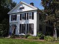
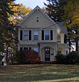
| 1 | Luman Andrews House |
 |
(#88003095) |
469 Andrews St. 41°37′23″N 72°49′52″W / 41.623056°N 72.831111°W |
This old house was built in 1745. It's also important because volcanic rock, used for Portland cement, was found here! | |
| 2 | Atwater Manufacturing Company |
(#88002678) |
335 Atwater St. 41°34′43″N 72°53′54″W / 41.578611°N 72.898333°W |
Plantsville | An important old factory building in Plantsville. | |
| 3 | Selah Barnes House |
(#88003114) |
282 Prospect St. 41°35′29″N 72°54′01″W / 41.591389°N 72.900278°W |
Plantsville | A historic house in Plantsville. | |
| 4 | Barnes-Frost House |
 |
(#88003109) |
1177 Marion Ave. 41°33′56″N 72°55′31″W / 41.565556°N 72.925278°W |
Marion | Built in 1795, this house shows off fancy Federal architecture. It was home to the Barnes and Frost families. |
| 5 | Blakeslee Forging Company |
(#88002676) |
100 W. Main St. 41°34′38″N 72°53′36″W / 41.577222°N 72.893333°W |
Plantsville | Another historic factory in Plantsville. | |
| 6 | Icabod Bradley House |
(#88003115) |
537 Shuttle Meadow Rd. 41°38′55″N 72°50′40″W / 41.648611°N 72.844444°W |
A historic house in Southington. | ||
| 7 | Clark Brothers Factory No. 1 |
(#88002679) |
1331 S. Main St. 41°34′03″N 72°54′10″W / 41.5675°N 72.902778°W |
Milldale | One of the Clark Brothers factories in Milldale. | |
| 8 | Clark Brothers Factory No. 2 |
(#88002680) |
409 Canal St. 41°34′15″N 72°53′46″W / 41.570833°N 72.896111°W |
Milldale | The second Clark Brothers factory building. | |
| 9 | Avery Clark House |
(#88003110) |
1460 Meriden Ave. 41°33′48″N 72°51′12″W / 41.563333°N 72.853333°W |
A historic house in Southington. | ||
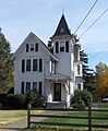
| 10 | Capt. Josiah Cowles House |
 |
(#88003102) |
184 Marion Ave. 41°35′05″N 72°54′12″W / 41.584722°N 72.903333°W |
Plantsville | This house, built around 1750, belonged to Captain Josiah Cowles. He was an important leader in early Southington. He helped provide for soldiers' families during the American Revolution. |
| 11 | Ebenezer Evans House |
(#88003101) |
17 Long Bottom Rd. 41°37′50″N 72°50′03″W / 41.630556°N 72.834167°W |
A historic house in Southington. | ||
| 12 | Farmington Canal-New Haven and Northampton Canal |
 |
(#85002664) |
Roughly from Suffield in Hartford County to New Haven in New Haven County 41°36′00″N 72°53′00″W / 41.599917°N 72.883472°W |
This used to be a canal, then a railroad, and now it's a popular walking and biking trail! | |
| 13 | Levi B. Frost House |
 |
(#87002037) |
1089 Marion Ave. 41°34′05″N 72°55′29″W / 41.568056°N 72.924722°W |
Marion | Also known as the Asa Barnes Tavern, a historic inn. |
| 14 | Stephen Grannis House |
(#88003119) |
1193 West St. 41°37′14″N 72°53′58″W / 41.620556°N 72.899444°W |
A historic house in Southington. | ||
| 15 | Timothy Hart House |
(#88003100) |
521 Flanders Rd. 41°37′09″N 72°50′43″W / 41.619167°N 72.845278°W |
A historic house in Southington. | ||
| 16 | House at 1010 Shuttle Meadow Road |
(#88003116) |
1010 Shuttle Meadow Rd. 41°38′58″N 72°51′12″W / 41.649444°N 72.853333°W |
A historic house in Southington. | ||
| 17 | House at 590 West Street |
(#88003118) |
590 West St. 41°36′16″N 72°53′57″W / 41.604444°N 72.899167°W |
A historic house in Southington. | ||
| 18 | Hubbard Park |
 |
(#97001466) |
Roughly bounded by W. Main St., Interstate 691, CT 66, Reservoir Ave., Edgewood Dr. 41°33′45″N 72°50′05″W / 41.5625°N 72.834722°W |
This large park is partly in Southington, Meriden, and Berlin. It's a great place to explore! | |
| 19 | Hurwood Company |
(#88002681) |
379 Summer St. 41°35′22″N 72°53′26″W / 41.589444°N 72.890556°W |
Plantsville | A historic company building in Plantsville. | |
| 20 | Lake Compounce Carousel |
(#78002865) |
West of Southington Center on Lake Ave. 41°38′21″N 72°55′22″W / 41.639167°N 72.922778°W |
This historic carousel is located at Lake Compounce, one of the oldest amusement parks in the United States! | ||
| 21 | Marion Historic District |
 |
(#88001423) |
Along Marion Ave. and Meriden-Waterbury Turnpike, in town of Southington and in town of Cheshire (in New Haven County) 41°33′50″N 72°55′29″W / 41.563889°N 72.924722°W |
This historic district covers parts of Southington and Cheshire. | |
| 22 | Meriden Avenue-Oakland Road Historic District |
 |
(#88000580) |
Roughly Oakland Rd. between Meriden and Berlin Aves., and Meriden Ave. between Oakland Rd. and Delhunty Dr. 41°35′31″N 72°52′26″W / 41.591944°N 72.873889°W |
This district includes historic homes along Oakland Road and Meriden Avenue. | |
| 23 | Roswell Moore II House |
(#88003093) |
1166 Andrews St. 41°36′18″N 72°49′44″W / 41.605°N 72.828889°W |
A historic house in Southington. | ||
| 24 | Peck, Stow & Wilcox Factory |
(#88002682) |
217 Center St. 41°36′08″N 72°52′59″W / 41.602222°N 72.883056°W |
An old factory building in Southington Center. | ||
| 25 | Plantsville Historic District |
 |
(#88002673) |
Roughly bounded by Prospect St., Summer St., the Quinnipiac River, Grove St., S. Main St., W. Main St., and West St. 41°35′26″N 72°53′35″W / 41.590556°N 72.893056°W |
This district covers a large historic area in Plantsville. | |
| 26 | Dr. J. Porter House |
(#88003096) |
391 Belleview Ave. 41°35′05″N 72°52′07″W / 41.584722°N 72.868611°W |
A historic house in Southington. | ||
| 27 | Pultz & Walkley Company |
(#88002677) |
120 W. Main St. 41°35′12″N 72°53′34″W / 41.586667°N 72.892778°W |
Plantsville | A historic company building in Plantsville. | |
| 28 | Jonathan Root House |
 |
(#88003113) |
140-142 N. Main St. 41°36′16″N 72°52′43″W / 41.604444°N 72.878611°W |
A historic house in Southington. | |
| 29 | Dr. Henry Skelton House |
(#88003117) |
889 S. Main St. 41°35′02″N 72°53′32″W / 41.583889°N 72.892222°W |
A historic house in Southington. | ||
| 30 | H. D. Smith Company Building |
 |
(#77001420) |
24 West St. 41°35′19″N 72°53′56″W / 41.588611°N 72.898889°W |
Plantsville | A historic building of the H. D. Smith Company. |
| 31 | Southington Center Historic District |
 |
(#88002961) |
Roughly N. Main St. north from Vermont Ave., and Berlin St. from Main St. to Academy Ln. 41°36′12″N 72°52′41″W / 41.603333°N 72.878056°W |
This district includes the historic center of Southington. | |
| 32 | Southington Public Library |
 |
(#89000015) |
239 Main St. in Southington Center 41°35′48″N 72°52′41″W / 41.596667°N 72.878056°W |
This building used to be the public library. Now, it's home to the local historical society! | |
| 33 | Horace Webster Farmhouse |
(#77001417) |
577 South End Rd. 41°34′01″N 72°52′27″W / 41.566944°N 72.874167°W |
Plantsville | A historic farmhouse in Plantsville. | |
| 34 | West Street School |
(#88002689) |
1432 West St. 41°37′39″N 72°54′03″W / 41.6275°N 72.900833°W |
A historic school building. | ||
| 35 | Rev. John Wightman House |
(#88003111) |
1024 Mount Vernon Rd. 41°35′56″N 72°55′32″W / 41.598889°N 72.925556°W |
A historic house in Southington. | ||
| 36 | Valentine Wightman House |
(#88003112) |
1112 Mount Vernon Rd. 41°36′04″N 72°55′32″W / 41.601111°N 72.925556°W |
A historic house in Southington. | ||
| 37 | Woodruff House |
(#88003097) |
377 Berlin St. 41°35′49″N 72°51′21″W / 41.596944°N 72.855833°W |
A historic house in Southington. | ||
| 38 | Capt. Samuel Woodruff House |
(#89000014) |
23 Old State Rd. 41°35′52″N 72°50′51″W / 41.597778°N 72.8475°W |
A historic house in Southington. | ||
| 39 | Ezekiel Woodruff House |
(#88003099) |
1152 East St. 41°35′41″N 72°50′32″W / 41.594722°N 72.842222°W |
A historic house in Southington. | ||
| 40 | Jotham Woodruff House |
(#88003120) |
137-139 Woodruff St. 41°36′07″N 72°52′13″W / 41.601944°N 72.870278°W |
A historic house in Southington. | ||
| 41 | Urbana Woodruff House |
(#88003098) |
1096 East St. 41°35′37″N 72°50′31″W / 41.593611°N 72.841944°W |
A historic house in Southington. |
Images for kids
-
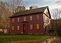
The Luman Andrews House, built in 1745.
-
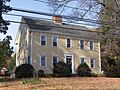
The Barnes-Frost House, a beautiful example of Federal architecture.
-
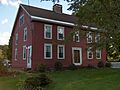
The Captain Josiah Cowles House, home of an early Southington leader.
-
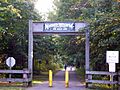
A sign for the Farmington Canal, now a popular trail.
-
The Asa Barnes Tavern, also known as the Levi B. Frost House.
-
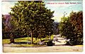
An old postcard showing the entrance to Hubbard Park.
-
A house in the Marion Historic District.
-
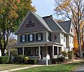
The Charles W. Beckley House in the Meriden Avenue-Oakland Road Historic District.
-
A house in the Plantsville Historic District.
-

The front of the Jonathan Root House.
-
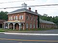
The H. D. Smith Company Building in Plantsville.
-
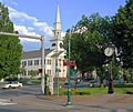
The historic Southington Center Historic District.
-
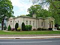
The former Southington Public Library building.
