
National Register of Historic Places listings in Fairfield County, Connecticut facts for kids

Fairfield County, Connecticut, is home to many amazing places that are listed on the National Register of Historic Places. This special list includes buildings, sites, and objects that are important to American history, architecture, archaeology, engineering, or culture. Think of it like a Hall of Fame for historic spots!
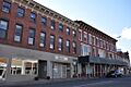
There are nearly 300 places in Fairfield County on this list. Some of these are in bigger cities like Bridgeport, Greenwich, Connecticut, and Stamford, Connecticut, and they have their own separate lists. This article focuses on the other 171 cool places that are spread across the rest of Fairfield County.
Many of these historic places are also National Historic Landmarks, which are even more important! About 46 of them are historic districts, meaning they are areas with many historic buildings that together tell a story.
Cool Architecture and Famous Homes
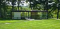
Fairfield County has a lot of different kinds of buildings. One interesting group is in New Canaan, Connecticut, where you can find many modern or International Style houses. These were designed by a group of architects called the "Harvard Five". Some famous examples include the Landis Gores House, the Richard and Geraldine Hodgson House, the amazing Philip Johnson Glass House, and the Noyes House. These homes look very different from older houses, often using lots of glass and simple shapes.
Many homes of famous people are also on the list:
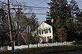
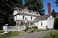
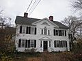
- The Stephen Tyng Mather Home in Darien, Connecticut belonged to Stephen Mather, who helped create and became the first director of the National Park Service. He worked hard to protect America's beautiful natural places.
- The Frederic Remington House in Ridgefield, Connecticut was the home of Frederic Remington, a famous painter and sculptor. He was known for his amazing artworks showing the American West, with cowboys, Native Americans, and landscapes.
- The Ida Tarbell House in Easton, Connecticut was where Ida Tarbell, a brave journalist, lived. She was a "muckraker," meaning she investigated and wrote about unfair practices, like those of the Standard Oil Company. Her book, The History of the Standard Oil Company, helped change laws.
- The Charles Ives House in Danbury, Connecticut was the birthplace of Charles Ives, a very important American composer. He was known for his unique and experimental music.
- The Maxwell E. Perkins House in New Canaan, Connecticut belonged to Maxwell E. Perkins, a famous book editor. He worked with legendary writers like Ernest Hemingway, F. Scott Fitzgerald, and Thomas Wolfe, helping them shape their masterpieces.
Historic Bridges and Lighthouses
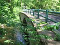
Fairfield County has many historic bridges, some of them quite old!
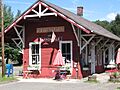
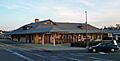
- Seven bridges are moveable bridges, which means they can open or swing to let boats pass. The Saugatuck River Bridge from 1884 is the oldest moveable bridge in Connecticut!
- The Washington Bridge is another important one, carrying a major road, U.S. 1.
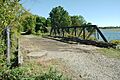
- Five of these are railway bridges, like the Mianus River Railroad Bridge and the Norwalk River Railroad Bridge.
- Some bridges are part of bigger projects, like the one at the Stevenson Dam Hydroelectric Plant, which helps create electricity.
- The Merritt Parkway itself is a historic listing, known for its many beautiful and uniquely designed bridges.
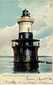
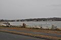
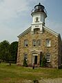
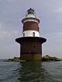
There are also nine historic lighthouses on the list, including the Greens Ledge Light and Peck Ledge Light off the coast of Norwalk, and the Stratford Point Light and Stratford Shoal Lighthouse near Stratford. Lighthouses are important because they helped guide ships safely in the past.
Revolutionary War Connections
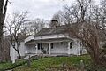
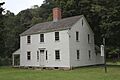
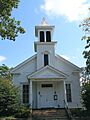
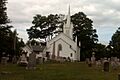
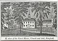
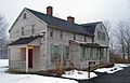
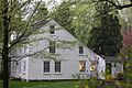
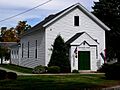
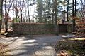
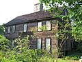
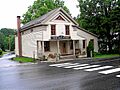
Seven sites in Fairfield County are listed because of their connection to the American Revolutionary War. These places were part of the route taken by French General Rochambeau and his troops in 1781. They marched through the county on their way to help the American forces win the Battle of Yorktown in Virginia. These sites still show what the army's well-planned route looked like back then. For example, the Caleb Baldwin Tavern in Newtown hosted French officers, and the Daniel Basset House in Monroe was the site of a ball for Rochambeau's army!
A Glimpse at Other Historic Places
This list includes many different types of historic places, from old homes to industrial sites. Here are a few examples:
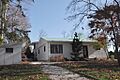
- The Allen House in Westport, Connecticut (built 1958) is a unique example of modern architecture in the area.
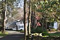
- Aspetuck Historic District in Easton and Weston shows what a farming community looked like in the early days of America. You can still see old houses and barns spread out, just like they were when farming was the main way of life.
- Birdcraft Sanctuary in Fairfield is the oldest bird sanctuary in the United States! It's where Mabel Osgood Wright started the idea of "birdscaping," which means designing gardens to attract birds.
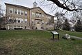
- The Commodore Hull School in Shelton (built 1907) is special because it was one of the first schools in Connecticut built to be completely fireproof, using terra cotta blocks and concrete.
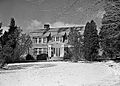
- The Lockwood-Mathews Mansion in Norwalk is a grand mansion built in 1864 in the fancy Second Empire style. It's like stepping back in time to see how wealthy families lived.
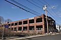
- The P. Robinson Fur Cutting Company in Danbury reminds us of Danbury's history as a major center for hat making.
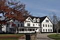
- The Weir Farm National Historic Site in Wilton and Ridgefield is a beautiful place that inspired many American artists. It's a great spot to learn about art and nature.
These are just a few of the many fascinating places in Fairfield County that are preserved because of their historical importance. They help us understand the past and appreciate the rich history of Connecticut!
|
Fairfield (city of Bridgeport) (town of Greenwich) (city of Stamford) | Hartford (city of Hartford) (town of Southington) (town of West Hartford) (town of Windsor) | Litchfield | Middlesex (city of Middletown) | New Haven (city of New Haven) | New London | Tolland | Windham |
Current listings
| Name on the Register | Image | Date listed | Location | City or town | Description | |
|---|---|---|---|---|---|---|
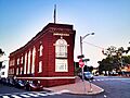
| 1 | The Allen House |
 |
(#10000492) |
4 Burritt's Landing North 41°06′57″N 73°22′32″W / 41.115833°N 73.375556°W |
Westport | Built in 1958, this house is the only known example in Westport of work by Chicago architect Roy Binkley, Jr.. |
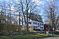
| 2 | Aspetuck Historic District |
 |
(#91000437) |
Roughly, Redding Rd. from its junction with Old Redding Rd. to Welles Hill Rd. and Old Redding Rd. north past the Aspetuck River 41°13′24″N 73°19′24″W / 41.223333°N 73.323333°W |
Easton and Weston | A historic district that shows what a farming community looked like in early America. It has widely spaced houses, barns, and large yards that were once fields or gardens. |
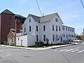
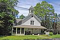
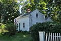
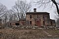
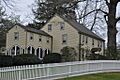
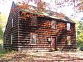
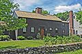
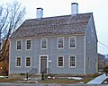
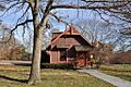
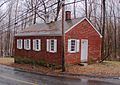
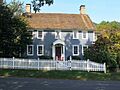
| 3 | Caleb Baldwin Tavern |
 |
(#02000869) |
32 Main St. 41°24′46″N 73°18′31″W / 41.412778°N 73.308611°W |
Newtown | Built around 1763, this house hosted officers from French commander Rochambeau's troops in 1781. It's a good example of 18th-century New England architecture. |
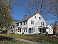
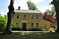
| 7 | Daniel Basset House |
 |
(#02000870) |
1024 Monroe Turnpike 41°20′58″N 73°11′53″W / 41.349444°N 73.198056°W |
Monroe | This colonial house was the site of a ball for a group of Rochambeau's army on June 30, 1781. |
| 10 | Birdcraft Sanctuary |
 |
(#82004371) |
314 Unquowa Rd. 41°08′43″N 73°15′31″W / 41.145278°N 73.258611°W |
Fairfield | The oldest bird sanctuary in the U.S., where Mabel Osgood Wright started the idea of "birdscaping." |
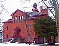
| 26 | Commodore Hull School |
 |
(#83001251) |
130 Oak Ave. 41°19′05″N 73°06′03″W / 41.318056°N 73.100833°W |
Shelton | Built in 1907, this former elementary school is believed to be the only one in Connecticut made of terra cotta blocks and reinforced concrete, designed to be fireproof. |
| 42 | Landis Gores House |
 |
(#02000189) |
192 Cross Ridge Rd. 41°11′54″N 73°29′48″W / 41.198333°N 73.496667°W |
New Canaan | An International Style house built in 1948, home of Harvard Five architect Landis Gores. |
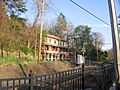
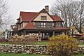
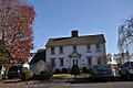
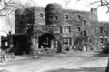
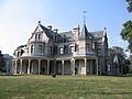
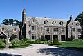
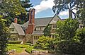
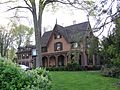
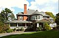
| 53 | Hearthstone Castle |
 |
(#87002184) |
18 Brushy Hill Rd. 41°22′41″N 73°26′55″W / 41.37808°N 73.44854°W |
Danbury | A castle-like house built in 1895. |
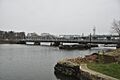
| 55 | Housatonic River Railroad Bridge |
.jpg) |
(#87000842) |
Amtrak right-of-way at the Housatonic River 41°12′19″N 73°06′37″W / 41.205278°N 73.110278°W |
Stratford and Milford | A railroad bridge over the Housatonic River. |
| 60 | Charles Ives House |
 |
(#76001968) |
7 Mountainville Ave. 41°22′54″N 73°26′43″W / 41.381667°N 73.445278°W |
Danbury | The 1780 house of the Ives family, where composer Charles Ives was born in 1874. |
| 61 | Philip Johnson Glass House |
|
(#97000341) |
798-856 Ponus Ridge Rd. 41°08′31″N 73°31′47″W / 41.141944°N 73.529722°W |
New Canaan | A famous modern house made of glass and steel by architect Philip Johnson. |
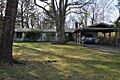
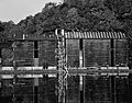
| 64 | Kaatz Icehouse |
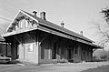
.jpg) |
(#77001395) |
North of Trumbull at 255 Whitney Ave. 41°17′00″N 73°13′03″W / 41.283333°N 73.2175°W |
Trumbull | A former warehouse that operated as an icehouse from 1908 to 1955. It was taken down in 1978. |
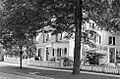
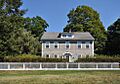
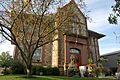
| 74 | Lockwood-Mathews Mansion |
 |
(#70000836) |
295 West Ave., in Central Norwalk 41°06′31″N 73°25′05″W / 41.108611°N 73.418056°W |
Norwalk | A grand mansion built in 1864 in the Second Empire style. |
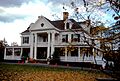
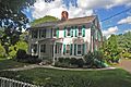
| 83 | Stephen Tyng Mather House |
 |
(#66000877) |
19 Stephen Mather Rd. 41°06′47″N 73°28′31″W / 41.113056°N 73.475278°W |
Darien | Home of Stephen Mather, who was a champion for creating the National Park Service and its first director. |
| 86 | Merritt Parkway |
.jpg) |
(#91000410) |
CT 15 and right-of-way between the New York state line and the Housatonic River bridge 41°05′05″N 73°35′35″W / 41.084722°N 73.593056°W |
Greenwich, Stamford, New Canaan, Norwalk, Westport, Fairfield, Trumbull, Stratford | A historic parkway known for its unique bridges and design. |
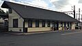
| 93 | New Haven Railroad Danbury Turntable |
(#05001048) |
120 White St. 41°23′49″N 73°26′47″W / 41.396944°N 73.446389°W |
Danbury | A railroad turntable in the yard of the Danbury Railway Museum. | |
| 102 | Norwalk Island Lighthouse |
 |
(#88003222) |
Sheffield Island 41°02′55″N 73°25′12″W / 41.048611°N 73.42°W |
Norwalk | A lighthouse on Sheffield Island, part of the Norwalk Islands. |
| 104 | Octagon House (Danbury) |
 |
(#73001945) |
21 Spring St. 41°23′42″N 73°27′34″W / 41.395°N 73.459444°W |
Danbury | An octagon house built in 1852, which is a house with eight sides. |
| 116 | Putnam Memorial State Park |
 |
(#70000683) |
Junction of Routes 58 (Black Rock Tpke.) and 107 (Park Rd.) 41°20′23″N 73°23′01″W / 41.339722°N 73.383611°W |
Redding | A state park with historical significance. |
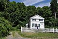
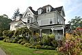
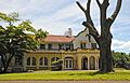
| 118 | Frederic Remington House |
.jpg) |
(#66000880) |
36 Oak Knoll Road. 41°17′17″N 73°31′01″W / 41.288056°N 73.516944°W |
Ridgefield | Home of Frederic Remington, a painter and sculptor famous for his artworks of the American West. |
| 125 | John Rogers Studio |
 |
(#66000881) |
33 Oenoke Ridge 41°09′01″N 73°29′53″W / 41.150278°N 73.498056°W |
New Canaan | The studio of John Rogers, a famous American sculptor from the 1800s. |
| 127 | Saugatuck River Bridge |
 |
(#87000126) |
CT 136 41°07′22″N 73°22′10″W / 41.122778°N 73.369444°W |
Westport | A swinging bridge from 1884, the oldest moveable bridge in the state. |
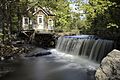
| 138 | Stevenson Dam Hydroelectric Plant |
 |
(#00001073) |
CT 34 41°23′03″N 73°10′16″W / 41.384167°N 73.171111°W |
Monroe | A dam, bridge, and powerhouse built in 1917 on the Housatonic River. |
| 140 | Stratford Point Lighthouse |
 |
(#89001476) |
Stratford Point at mouth of Housatonic River 41°09′07″N 73°06′13″W / 41.151944°N 73.103611°W |
Stratford | A lighthouse located at Stratford Point. |
| 141 | Stratford Shoal Lighthouse |
.jpg) |
(#89001477) |
Middleground Shoal, Long Island Sound 41°03′34″N 73°06′06″W / 41.059444°N 73.101667°W |
Stratford | A lighthouse on a shoal in the middle of Long Island Sound. |
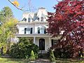
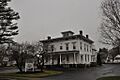
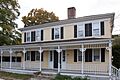
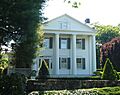
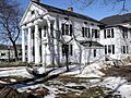
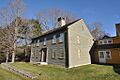
| 143 | Jonathan Sturges House |
 |
(#84000247) |
449 Mill Plain Rd. 41°08′56″N 73°16′06″W / 41.148889°N 73.268333°W |
Fairfield | A Gothic Revival style cottage built in 1840. |
| 146 | Ida Tarbell House |
 |
(#93001602) |
320 Valley Rd. 41°18′25″N 73°19′56″W / 41.306944°N 73.332222°W |
Easton | Home of the famous journalist and author, Ida Tarbell, who wrote The History of the Standard Oil Company. |
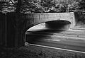
| 157 | Washington Bridge |
|
(#04001093) |
U.S. Route 1 at the Housatonic River 41°12′01″N 73°06′39″W / 41.200278°N 73.110833°W |
Stratford | A bridge carrying U.S. Route 1 over the Housatonic River. |
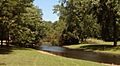
| 159 | Weir Farm National Historic Site |
|
(#03000284) |
735 Nod Hill Road 41°15′21″N 73°27′21″W / 41.25592°N 73.455963°W |
Wilton and Ridgefield | A national historic site that was once the home and workplace of American Impressionist painter J. Alden Weir. |
Images for kids
-
Ball and Roller Bearing Company
-
Caleb Baldwin Tavern
-
Aspetuck Historic District
-
Daniel and Esther Bartlett House
-

Daniel Basset House
-
Benedict House and Shop
-
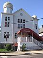
Beth Israel Synagogue
-
Birdcraft Sanctuary
-

Nathan B. Booth House
-
Boothe Homestead
-

Boston Post Road Historic District
-
Bradley Edge Tool Company Historic District
-
Bradley-Hubbell House
-

Bradley-Wheeler House
-
Branchville Railroad Tenement
-

Marcel Breuer House II
-
Bronson Windmill
-
Brookfield Center Historic District
-
Hugh Cain Fulling Mill and Elias Glover Woolen Mill Archeological Site
-
Camps Nos. 10 and 41 of Rochambeau's Army marker
-
Cannondale Historic District
-

Arthur and Lyn Chivvis House
-
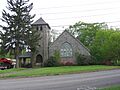
Christ Episcopal Church and Tashua Burial Ground
-
Commodore Hull School
-
Compo-Owenoke Historic District
-
Cosier-Murphy House
-
Nathaniel Curtis House
-
Hanford Davenport House
-
Durisol House
-
Fairfield Historic District
-
Fairfield Railroad Stations
-

Five Mile River Landing Historic District
-

Elinor and Sherman Ford House
-

Gallaher Estate
-
Georgetown Historic District
-
Glover House
-
Godillot Place
-
Landis Gores House
-
Green Farms School
-
Greenfield Hill Grange No. 133
-
Greenfield Hill Historic District
-
Greens Ledge Lighthouse
-
Greenwood Avenue Historic District
-
Isaac Davis and Marion Dalton Hall House
-
Hampton Inn
-
Hattertown Historic District
-
Haviland and Elizabeth Streets-Hanford Place Historic District
-
Thomas Hawley House
-
Hearthstone Castle
-
Richard and Geraldine Hodgson House
-

Housatonic River Railroad Bridge
-
Hoyt-Burwell-Morse House
-
Huntington Center Historic District
-
Hurlbutt Street School
-

Thomas Hyatt House
-
Charles Ives House
-
Philip Johnson Glass House
-
Capt. David Judson House
-

Lewis June House
-
Kaatz Icehouse
-
Keeler Tavern
-
Enos Kellogg House
-

Kettle Creek Historic District
-

Kings Highway North Historic District
-

David Lambert House
-
John Black Lee House I
-
LeRoy Shirt Company Factory
-
Isaac Lewis House
-
Lockwood-Mathews Mansion
-
Locust Avenue School
-
Joseph Loth Company Building
-
Phineas Chapman Lounsbury House
-
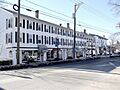
Main Street Historic District
-
David Mallett, Jr., House
-
March Route of Rochambeau's Army: Reservoir Road
-

March Route of Rochambeau's Army: Ridgebury Road
-
Marvin Tavern
-
Stephen Tyng Mather House
-

Meadowlands
-
Meeker's Hardware
-
Merritt Parkway
-
Mill Cove Historic District
-
Beaven W. Mills House
-
Willis N. Mills House
-
Monroe Center Historic District
-

Charles and Peggy Murphy House
-
National Hall Historic District
-
New York Belting and Packing Co.
-
Newtown Borough Historic District
-
Nichols Farms Historic District
-

Nichols Satinet Mill Site
-
Norfield Historic District
-
Norwalk City Hall
-
Norwalk Green Historic District
-
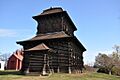
Noyes House
-
Norwalk Island Lighthouse
-
Norwalk River Railroad Bridge
-

Octagon House (Danbury)
-
David Ogden House
-
Old Mine Park Archeological Site
-
John Osborne House
-
Oysterman's Row
-
Peck Ledge Lighthouse
-
Maxwell E. Perkins House
-
Perry Avenue Bridge
-
Pine Creek Park Bridge
-
Plumb Memorial Library
-
Pond-Weed House
-
Verneur Pratt Historic District
-
Putnam Memorial State Park
-
Redding Center Historic District
-
Frederic Remington House
-
Restmore
-
John Rider House
-

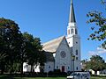
Ridgebury Congregational Church
-
Ridgefield Center Historic District
-
P. Robinson Fur Cutting Company
-
Rock Ledge
-
John Rogers Studio
-
Sanford-Curtis-Thurber House
-
Saugatuck River Bridge
-

Saugatuck River Railroad Bridge
-
Seth Seelye House
-
Shambaugh House
-
Sherman Historic District
-
Silvermine Center Historic District
-
Sloan-Raymond-Fitch House
-
South Main and Washington Streets Historic District
-

Southport Historic District
-
Southport Railroad Stations
-
Sterling Homestead
-

Stevenson Dam Hydroelectric Plant
-
Stratford Center Historic District
-

Stratford Point Lighthouse
-

Stratford Shoal Lighthouse
-
Sturges-Wright House
-
Jonathan Sturges House
-
James Swallen House
-

System House
-
Ida Tarbell House
-
Tarrywile
-
Corinne and George Liston Tatum, Jr., House
-
Town Hall (Westport, Connecticut)
-
Umpawaug District School
-
Union Station (Danbury, Connecticut)
-
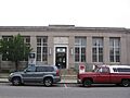
US Post Office-South Norwalk Main
-
United States Post Office, Westport, Connecticut
-
Village Creek
-
Wall Street Historic District
-
Washington Bridge
-
David Jr. and Sarah Webb House
-
Weir Farm National Historic Site
-

West Mountain Historic District
-
Westport Bank and Trust Company
-

Westport Center Historic District
-
Ephraim Wheeler House
-
Williams House
-
Wilton Center Historic District


.jpg)


.jpg)


.jpg)


