
National Register of Historic Places listings in Tolland County, Connecticut facts for kids

Have you ever wondered about the oldest and most important buildings or places in your community? In Tolland County, Connecticut, there are many special spots that are officially recognized for their history! These places are listed on something called the National Register of Historic Places.
The National Register of Historic Places is like a special list kept by the United States government. It helps to find and protect buildings, sites, and objects that are important to American history, architecture, archaeology, engineering, or culture. When a place is on this list, it means it's worth saving for future generations to learn from and enjoy.
In Tolland County, there are 51 different properties and areas that have made it onto this important list. These include old houses, schools, mills, and even whole neighborhoods! Each one tells a unique story about the past. You can even see where some of these places are on an online map if their exact location is shared.
|
Fairfield (city of Bridgeport) (town of Greenwich) (city of Stamford) | Hartford (city of Hartford) (town of Southington) (town of West Hartford) (town of Windsor) | Litchfield | Middlesex (city of Middletown) | New Haven (city of New Haven) | New London | Tolland | Windham |
What Makes a Place Historic?
To be added to the National Register, a place must be truly special. It might be linked to important events, famous people, or have a unique design. Sometimes, it's a place where we can learn a lot about how people lived long ago, like an old factory or a farm.
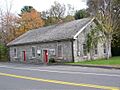
Historic Districts: Whole Neighborhoods with a Story
You'll notice many places on the list are called "Historic Districts." This means it's not just one building, but a whole area or neighborhood that has many historic buildings together. These districts often show how a town grew over time, with homes, churches, and shops from different periods.
Andover Center Historic District
One example is the Andover Center Historic District in Andover. This area includes roads like Hebron Road and Boston Hill Road. It's special because it shows what a traditional New England town center looked like many years ago. It helps us imagine life in the past.
Bolton Green Historic District
Another district is the Bolton Green Historic District in Bolton. This area is centered around the town's "Green," which is a common feature in old New England towns. The Green was often the heart of the community, where people gathered and important buildings like churches and town halls were located.
Famous People and Important Events
Some historic places are famous because of the people who lived there or the big events that happened there.
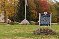
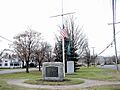
Captain Nathan Hale Monument
In Coventry, you can find the Captain Nathan Hale Monument. Nathan Hale was a brave American soldier during the American Revolutionary War. He is famous for saying, "I only regret that I have but one life to lose for my country." This monument honors his courage and sacrifice.
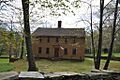
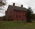
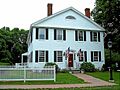
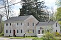
Nathan Hale Homestead
Also in Coventry is the Nathan Hale Homestead. This was the actual home where Nathan Hale grew up. It's a great place to visit to see what life was like for families in Connecticut during the 1700s. It helps us connect with history in a very real way.
Rochambeau's Army March Route
Did you know that during the American Revolutionary War, a French army led by General Rochambeau marched through Connecticut? Parts of their route, like the March Route of Rochambeau's Army: Bailey Road in Bolton and March Route of Rochambeau's Army: Hutchinson Road in Andover, are on the National Register. These roads are important because they show the path this army took to help America win its independence.
Old Buildings with New Uses
Many historic buildings have changed over time. They might have been built for one purpose, but now they are used for something completely different!
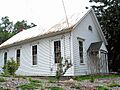
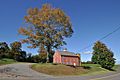
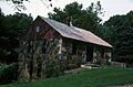
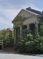
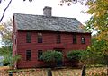
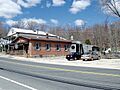
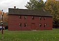
Brigham's Tavern
Brigham's Tavern in Coventry was once a busy inn where travelers could stop for a meal and a place to sleep. Imagine stagecoaches pulling up to its doors! Today, it still stands as a reminder of those early travel days.
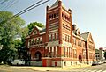
Old Rockville High School and East School
In Vernon, the Old Rockville High School and East School building is now used by the Board of Education. It's cool to think that a building where students once learned their ABCs is now where important decisions about schools are made!
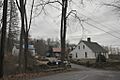
Florence Mill
The Florence Mill in Vernon was once a busy factory. Mills like this were very important for making goods like textiles (cloth) in the past. They were often powered by water. Even though it's not a mill anymore, it reminds us of the industrial history of the area.
Unique and Interesting Places
Not all historic places are buildings. Some are unique sites that tell a different kind of story.
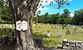
Mansfield Center Cemetery
The Mansfield Center Cemetery in Mansfield is more than just a burial ground. Old cemeteries can be like outdoor museums, with old gravestones that show art and history from long ago. They can tell us about the people who lived in the town and how they lived and died.
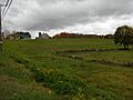
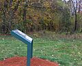
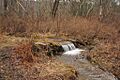
Sharpe's Trout Hatchery Site
In Vernon, the Sharpe's Trout Hatchery Site at Valley Falls Park is on the list. A hatchery is a place where fish are raised. This site shows how people in the past worked with nature and managed resources like fish.
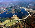
Mansfield Hollow Dam
The Mansfield Hollow Dam is a large structure that helps control water and create a lake. It's important for its engineering and for how it has shaped the landscape and water resources of the area. It even extends into another county!
Images for kids
-
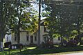
Andover Center Historic District
-
Bolton Green Historic District
-
Brigham's Tavern
-
John Cady House
-
Capron-Phillips House
-
Columbia Green Historic District
-
Jared Cone House
-
Coventry Glass Factory Historic District
-

Eldredge Mills Archeological District
-
Ellington Center Historic District
-
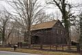
Farwell Barn (Jacobson Barn)
-
Fifth Camp of Rochambeau's Infantry
-
Florence Mill
-
Gurleyville Historic District
-
Nathan Hale Homestead
-
Hebron Center Historic District
-
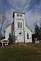
Knesseth Israel Synagogue
-
Loomis-Pomeroy House
-
Mansfield Center Cemetery
-
Mansfield Center Historic District
-
Mansfield Hollow Dam
-
Mansfield Hollow Historic District
-
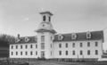
Mansfield Training School and Hospital
-
March Route of Rochambeau's Army: Bailey Road
-

March Route of Rochambeau's Army: Hutchinson Road
-

Minterburn Mill
-
Old Rockville High School and East School
-
Oliver White Tavern
-
Parker-Hutchinson Farm
-
Augustus Post House
-
Rockville Historic District
-
Saxony Mill (destroyed by fire in 1994)
-
Sharpe's Trout Hatchery Site
-

Somers Historic District
-

Somersville Historic District
-
South Coventry Historic District
-

Elias Sprague House
-

Spring Hill Historic District
-
Stafford Hollow Historic District
-
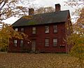
Strong House
-
Talcottville Historic District
-
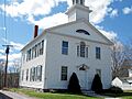
Tolland County Courthouse
-
Tolland Green Historic District
-

Union Green Historic District
-

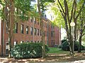
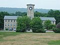
University of Connecticut Historic District-Connecticut Agricultural School
-

Valley Falls Cotton Mill Site
-
White's Tavern
-
Eleazer Williams House
-
Willington Common Historic District


_CT.jpg)


_CT.jpg)


