
National Register of Historic Places listings in New Haven, Connecticut facts for kids

This article lists all the amazing historic places and areas in New Haven, Connecticut, that are officially recognized on the National Register of Historic Places. Think of it like a special list of important buildings and neighborhoods that tell a big part of America's story!
New Haven County has 270 places on this list. Out of those, 68 are right here in New Haven city. This includes 9 super important places called National Historic Landmarks. We'll explore these cool spots below!
|
Fairfield (city of Bridgeport) (town of Greenwich) (city of Stamford) | Hartford (city of Hartford) (town of Southington) (town of West Hartford) (town of Windsor) | Litchfield | Middlesex (city of Middletown) | New Haven (city of New Haven) | New London | Tolland | Windham |
Historic Places You Can Visit Today
| Name on the Register | Image | Date listed | Location | Neighborhood | Description | |
|---|---|---|---|---|---|---|
| 1 | Ahavas Sholem Synagogue |
 |
(#95000559) |
30 White St. 41°17′54″N 72°56′25″W / 41.298333°N 72.940278°W |
Hill | This old synagogue has a really fancy front. It was built to show the Jewish community's presence in the neighborhood. |
| 2 | Armstrong Rubber Company Building |
 |
(#100006451) |
500 Sargent Dr. 41°17′48″N 72°55′07″W / 41.2967°N 72.9185°W |
Long Wharf | This building is a famous example of brutalism architecture. It was designed by the well-known architect Marcel Breuer. |
| 3 | M. Armstrong and Company Carriage Factory |
 |
(#11000612) |
433 Chapel St. 41°18′13″N 72°54′44″W / 41.303611°N 72.912222°W |
Fair Haven | This building used to be a factory where horse-drawn carriages were made way back in the 1800s. |
| 4 | Beaver Hills Historic District |
 |
(#86002108) |
Roughly bounded by Crescent St., Goffe Terrace, and Boulevard 41°19′28″N 72°56′39″W / 41.324444°N 72.944167°W |
Beaver Hills | This neighborhood was built in the early 1900s. It was one of the first areas designed for people who owned cars! You can see many old Colonial Revival homes here. |
| 5 | Beth Israel Synagogue |
 |
(#95000578) |
232 Orchard St. 41°17′54″N 72°56′25″W / 41.298333°N 72.940278°W |
West River | This Colonial Revival building was built in 1925. It was designed by architect Louis Abramowitz for an orthodox synagogue. |
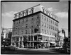
| 6 | Elisha Blackman Building |
 |
(#78002863) |
176 York St. 41°18′29″N 72°55′57″W / 41.308056°N 72.9325°W |
Downtown | Built in 1883, this was the first commercial building in a residential area. It has a very fancy design! |
| 7 | Chapel Street Historic District |
 |
(#84001123) |
Roughly bounded by Park, Chapel, Temple, George, and Crown Sts. 41°18′20″N 72°55′47″W / 41.305556°N 72.929722°W |
Downtown and Dwight | This historic area shows how New Haven grew as a business center in the late 1800s and early 1900s. |
| 8 | Russell Henry Chittenden House |
 |
(#75001944) |
83 Trumbull St. 41°18′48″N 72°55′23″W / 41.313333°N 72.923056°W |
Prospect Hill | This was the home of Russell Henry Chittenden, who is known as the "father of American biochemistry." He lived here from 1887 to 1943. The house has a unique shape and Queen Anne features. |
| 9 | Christ Church New Haven |
 |
(#09000420) |
70 Broadway 41°18′44″N 72°55′56″W / 41.31225°N 72.932269°W |
Dixwell (in Broadway district) |
This Episcopal church was finished in 1898. It was designed in the Gothic style and has a stone tower like those at the University of Oxford. |
| 10 | Connecticut Agricultural Experiment Station |
 |
(#66000805) |
123 Huntington St. 41°19′51″N 72°55′10″W / 41.330833°N 72.919444°W |
Prospect Hill | This is where the very first agricultural experiment station in the United States was located! It started in 1875 and moved to New Haven in 1877. Its library, built in 1882-83, is the oldest building of any such station. Important research on vitamins happened here. |
| 11 | Connecticut Hall, Yale University |
 |
(#66000806) |
Bounded by High, Chapel, Elm, and College Sts. 41°18′29″N 72°55′46″W / 41.308056°N 72.929444°W |
Downtown | Built in 1752, this Georgian-style building is the oldest at Yale University. It's the only original building left from the "Old Brick Row." |
| 12 | John Cook House |
 |
(#83003576) |
35 Elm St. 41°18′26″N 72°55′21″W / 41.307222°N 72.9225°W |
Downtown | This is one of New Haven's oldest stone buildings. It has cool sandstone details and even a ballroom on the third floor! |
| 13 | George W. Crawford House |
 |
(#15000113) |
84–96 Park St. 41°18′24″N 72°56′07″W / 41.3066°N 72.9354°W |
Dwight | This apartment building is a Brutalist design by architect Paul Rudolph. |
| 14 | Dixwell Avenue Congregational United Church of Christ |
 |
(#100003148) |
217 Dixwell Ave. 41°19′08″N 72°56′02″W / 41.3190°N 72.9339°W |
Dixwell | This Brutalist building was designed by John M. Johansen. It's home to a very old African American church community. |
| 15 | James Dwight Dana House |
.jpg) |
(#66000874) |
24 Hillhouse Ave. 41°18′47″N 72°55′30″W / 41.313056°N 72.925°W |
Downtown | This house was the home of James Dwight Dana, a famous Yale geologist. It was designed by Henry Austin. |
| 16 | Dwight Street Historic District |
 |
(#83001281) |
Roughly bounded by Park, N. Frontage, Scranton, Sherman, and Elm Sts. 41°18′38″N 72°56′23″W / 41.310556°N 72.939722°W |
Dwight and West River | This historic area has many well-preserved homes from the 1800s and early 1900s. |
| 17 | East Rock Park |
 |
(#97000299) |
Roughly bounded by State, Davis, and Livingston Sts., Park and Mitchell Drs., and Whitney Ave. 41°19′41″N 72°54′21″W / 41.328056°N 72.905833°W |
East Rock and Hamden | This beautiful park was designed by the Olmsted Brothers. It includes East Rock Ridge and the Soldiers' and Sailors' Monument. |
| 18 | Edgerton |
 |
(#88001469) |
840 Whitney Ave. 41°20′04″N 72°54′52″W / 41.334361°N 72.914333°W |
Prospect Hill | This 20-acre historic park was once the estate of a wealthy industrialist, Frederick F. Brewster. While his mansion is gone, you can still see the gatehouse, carriage house, and lovely gardens. |
| 19 | Edgewood Park Historic District |
 |
(#86001991) |
Roughly bounded by Whalley Ave. and Elm St., Sherman Ave. and Boulevard, Edgewood and Derby, and Yale Aves. 41°18′55″N 72°57′16″W / 41.315278°N 72.954444°W |
Edgewood, Westville, and West River | This historic neighborhood has homes from the late 1800s, including Queen Anne and Colonial Revival styles. |
| 20 | Farmington Canal-New Haven and Northampton Canal |
 |
(#85002664) |
Roughly from Suffield in Hartford County to New Haven in New Haven County 41°19′26″N 72°55′51″W / 41.323889°N 72.930778°W |
Newhallville, Dixwell, and Downtown | This used to be a canal, then a railroad, and now it's a popular trail for walking and biking! It stretches far north into other towns. |
| 21 | Five Mile Point Lighthouse |
 |
(#90001108) |
Lighthouse Point Park 41°14′56″N 72°54′14″W / 41.248889°N 72.903889°W |
East Shore | This lighthouse, built in 1847, has eight sides! |
| 22 | Fort Nathan Hale |
 |
(#70000711) |
Southern end of Woodward Ave. 41°16′12″N 72°53′55″W / 41.27°N 72.898611°W |
East Shore | This spot has been home to forts since the colonial times, all the way through the Civil War. |
| 23 | Goffe Street Special School for Colored Children |
 |
(#79002643) |
106 Goffe St. 41°18′56″N 72°56′06″W / 41.315556°N 72.935°W |
Dixwell | This school was built in 1864 for African American children. Architect Henry Austin designed it for free! After 1874, when all children could attend public schools, this building became a community center. |
| 24 | Grove Street Cemetery |
 |
(#97000830) |
200 Grove St. 41°18′49″N 72°55′39″W / 41.313611°N 72.9275°W |
Downtown | Many famous people from Yale and New Haven are buried here. This includes Roger Sherman, Noah Webster, and Eli Whitney. |
| 25 | Hall-Benedict Drug Company Building |
 |
(#86001205) |
763–767 Orange St. 41°19′16″N 72°54′45″W / 41.321111°N 72.9125°W |
East Rock | This commercial building from 1909 is very well-preserved. |
| 26 | Hillhouse Avenue Historic District |
 |
(#85002507) |
Bounded by Sachem, Temple, Trumbull, and Prospect Sts., Whitney and Hillhouse Aves., and railroad tracks 41°18′50″N 72°55′23″W / 41.313889°N 72.923056°W |
Prospect Hill and Downtown | This historic street is famous for its beautiful mansions from the 1800s. |
| 27 | Elizabeth R. Hooker House |
 |
(#09000695) |
123 Edgehill Rd. 41°19′58″N 72°55′00″W / 41.332697°N 72.916717°W |
Prospect Hill | This Arts and Crafts style house was built in 1914. It was designed for Elizabeth R. Hooker, a well-known activist. |
| 28 | Howard Avenue Historic District |
 |
(#85002308) |
Properties along Howard Ave. between Interstate 95 and Washington St. 41°17′31″N 72°55′59″W / 41.291944°N 72.933056°W |
Hill (including City Point) |
This area has many well-preserved buildings from the late 1800s. |
| 29 | Imperial Granum-Joseph Parker Buildings |
 |
(#86000409) |
47 and 49–51 Elm St. 41°18′27″N 72°55′23″W / 41.3075°N 72.923056°W |
Downtown | These two commercial buildings were designed by Henry Austin. They are considered very fine examples of his work. |
| 30 | Lighthouse Point Carousel |
 |
(#83003578) |
Lighthouse Point Park, Lighthouse Ave. 41°14′54″N 72°54′12″W / 41.248333°N 72.903333°W |
East Shore | This historic carousel from the early 1900s is inside a beautiful Renaissance Revival style building. |
| 31 | Lincoln Theatre |
 |
(#84001134) |
1 Lincoln St. 41°18′43″N 72°55′12″W / 41.311944°N 72.92°W |
Downtown | This theater, built in 1925, has a unique English free style front. |
| 32 | Othniel C. Marsh House |
.jpg) |
(#66000875) |
360 Prospect St. 41°19′19″N 72°55′30″W / 41.321944°N 72.925°W |
Prospect Hill | This was the home of Othniel Charles Marsh, a famous Yale paleontologist. Today, it's part of the Yale School of Forestry. |
| 33 | Lafayette B. Mendel House |
 |
(#76002138) |
18 Trumbull St. 41°18′39″N 72°55′07″W / 41.310833°N 72.918611°W |
Downtown | This house was the home of Lafayette Mendel, a Yale biochemist. It was designed by Henry Austin. |
| 34 | Dr. Mary B. Moody House |
 |
(#100000930) |
154 E. Grand Ave. 41°18′23″N 72°52′55″W / 41.306525°N 72.881821°W |
Fair Haven Heights | This was the home of Mary Blair Moody, a physician. |
| 35 | Morris Cove Historic District |
 |
(#100002320) |
Between Dean & Myron Sts., Morris Causeway & Townsend Ave. 41°15′52″N 72°53′41″W / 41.264315°N 72.894725°W |
East Shore | This area was once a popular vacation spot and a neighborhood built around streetcar lines. It has homes from the early 1900s. |
| 36 | Morris House |
 |
(#72001341) |
325 Lighthouse Rd. 41°15′17″N 72°53′46″W / 41.2548°N 72.8960°W |
East Shore | This is one of the oldest buildings still standing in New Haven! |
| 37 | Mory's |
 |
(#04001552) |
306 York St. 41°18′41″N 72°55′54″W / 41.311389°N 72.931667°W |
Dixwell (in Broadway district) |
This is a famous private club right next to Yale University. |
| 38 | New Haven City Hall |
 |
(#75001940) |
161 Church St. 41°18′26″N 72°55′29″W / 41.307222°N 72.924722°W |
Downtown | This Victorian Gothic building was designed by Henry Austin. |
| 39 | New Haven Armory |
 |
(#100006556) |
270 Goffe St. 41°19′07″N 72°56′21″W / 41.3187°N 72.9391°W |
Dixwell | This huge Romanesque Revival building was constructed between 1928 and 1930. |
| 39 | New Haven Clock Company Factory |
 |
(#100000761) |
133 Hamilton St. 41°18′26″N 72°54′45″W / 41.307085°N 72.912472°W |
Wooster Square | This was originally a large complex of 14 buildings where clocks were made in the 1800s. |
| 40 | New Haven County Courthouse |
 |
(#03000404) |
121 Elm St. 41°18′38″N 72°55′27″W / 41.310556°N 72.924167°W |
Downtown | This Beaux Arts building from 1917 faces New Haven Green. It has some of the most grand rooms in the city! |
| 41 | New Haven Green Historic District |
 |
(#70000838) |
Bounded by Chapel, College, Elm, and Church Sts. 41°18′27″N 72°55′37″W / 41.3075°N 72.926944°W |
Downtown | This large town green includes three historic churches. It's a central part of New Haven's history. |
| 42 | New Haven Jewish Home for the Aged |
 |
(#79002641) |
169 Davenport Ave. 41°18′09″N 72°56′23″W / 41.3025°N 72.939722°W |
Hill | This historic nursing home has beautiful Beaux Arts style architecture. |
| 43 | New Haven Lawn Club |
 |
(#03000309) |
193 Whitney Ave. 41°18′57″N 72°55′10″W / 41.315833°N 72.919444°W |
East Rock | The clubhouse, designed by Douglas Orr, mixes Colonial Revival and Art Moderne styles. |
| 44 | New Haven Railroad Station |
 |
(#75001941) |
Union Ave. 41°17′51″N 72°55′37″W / 41.2975°N 72.926944°W |
Long Wharf | This Beaux-Arts style train station was designed by Cass Gilbert. |
| 45 | Caroline Nicoll House |
 |
(#83001283) |
27 Elm St. 41°18′27″N 72°55′19″W / 41.3075°N 72.921861°W |
Downtown | This townhouse from 1828 shows Federal and Greek Revival styles. It's right next to the John Cook House. |
| 46 | Ninth Square Historic District |
 |
(#84001135) |
Roughly bounded by Church, State, George, and Court Sts. 41°18′17″N 72°55′28″W / 41.304722°N 72.924444°W |
Downtown | This historic business area has buildings from the 1800s and early 1900s. |
| 47 | Orange Street Historic District |
 |
(#85002314) |
Roughly bounded by Whitney Ave., State, Eagle, and Trumbull Sts.; also portions of Anderson, Canner, Cottage, Eagle, Foster, Nash, Nicoll, North Bank & Willow Sts. 41°18′56″N 72°54′55″W / 41.315556°N 72.915278°W |
East Rock | This area has many well-preserved homes from the 1800s. Some new parts were added to the historic district in 2017. |
| 48 | Oyster Point Historic District |
 |
(#89001085) |
Roughly bounded by Interstate 95, S. Water St., Howard Ave., Sea St., and Greenwich Ave. 41°16′59″N 72°55′47″W / 41.283056°N 72.929722°W |
Hill (City Point section) |
This area was once a big center for oystering until 1925. You can still see unique homes built for oystermen here. |
| 49 | William Pinto House |
 |
(#85002316) |
275 Orange St. 41°18′29″N 72°55′21″W / 41.308056°N 72.9225°W |
Downtown | This Federal style house from 1810 was once home to Eli Whitney, the inventor of the cotton gin! |
| 50 | Plymouth Congregational Church |
 |
(#83001250) |
1469 Chapel St. 41°18′41″N 72°56′40″W / 41.311389°N 72.944444°W |
Dwight | This brownstone church from the late 1800s was built in the Romanesque Revival style. After some damage, it was rebuilt inside for offices. |
| 51 | Prospect Hill Historic District |
 |
(#79002670) |
Area between Whitney Avenue and Winchester Avenue north of Edwards Street/Munson Street 41°19′30″N 72°55′15″W / 41.325°N 72.920833°W |
Prospect Hill and Dixwell | This area is known for its historic mansions and some important institutional buildings. |
| 52 | Quinnipiac Brewery |
 |
(#83001285) |
19-23 River St. 41°18′14″N 72°53′37″W / 41.303889°N 72.893611°W |
Fair Haven | This factory complex is dominated by a six-story main building in the Romanesque Revival style. |
| 53 | Quinnipiac River Historic District |
 |
(#84001139) |
Roughly bounded by Quinnipiac Ave., Lexington, Chapel, Ferry, Pine, Front, and Lombard Sts. 41°18′35″N 72°52′59″W / 41.309722°N 72.883056°W |
Fair Haven and Fair Haven Heights | This historic riverside village dates all the way back to the 1700s! |
| 54 | Raynham |
 |
(#80004062) |
709 Townsend Ave. 41°16′34″N 72°53′42″W / 41.276111°N 72.895°W |
East Shore | This is a Gothic revival mansion with a large estate around it. |
| 55 | River Street Historic District |
 |
(#88003213) |
Roughly bounded by Chapel St., Blatchley Ave., New Haven Harbor, and James St. 41°18′08″N 72°54′04″W / 41.302222°N 72.901111°W |
Fair Haven | This industrial area was historically focused on businesses that worked with metal. |
| 56 | Southern New England Telephone Company Administrative Building |
 |
(#97001447) |
227 Church St. 41°18′33″N 72°55′25″W / 41.309167°N 72.923611°W |
Downtown | This is an Art Deco style building designed by Douglas Orr. |
| 57 | Southwest Ledge Lighthouse |
 |
(#89001475) |
Southwestern end of the east breakwater at the entrance to New Haven Harbor 41°13′53″N 72°55′25″W / 41.231389°N 72.923611°W |
New Haven Harbor | Finished in 1877, this lighthouse was one of the first to be built on a special cylindrical iron foundation. This was a big invention for lighthouses dealing with shifting ice! |
| 58 | St. Luke's Episcopal Church |
 |
(#03001170) |
111-113 Whalley Ave. 41°18′51″N 72°56′09″W / 41.314167°N 72.935833°W |
Dixwell | This Gothic revival church was built in 1905 for an African American church community that started in 1844. |
| 59 | Strouse, Adler Company Corset Factory |
 |
(#02000864) |
78-84 Olive St. 41°18′20″N 72°55′11″W / 41.305556°N 72.919722°W |
Wooster Square | This historic factory complex was built between 1876 and 1923. |
| 60 | Trowbridge Square Historic District |
 |
(#85002311) |
Roughly bounded by Columbus and Howard Aves. 41°17′47″N 72°55′55″W / 41.296389°N 72.931944°W |
Hill | This neighborhood from the 1800s is very well-preserved and shows what working-class areas looked like back then. |
| 61 | United States Post Office and Court House |
 |
(#15000586) |
145 Church St. 41°18′24″N 72°55′30″W / 41.3066°N 72.9249°W |
Downtown | This grand 1919 courthouse is built in the classical revival style and covered in Tennessee marble. |
| 62 | Upper State Street Historic District |
 |
(#84001143) |
Roughly State St. from Bradley St. to Mill River St. 41°18′53″N 72°54′41″W / 41.314722°N 72.911389°W |
East Rock | This historic area was a busy business district in the late 1800s. |
| 63 | Welch Training School |
 |
(#83001286) |
495 Congress Ave. 41°18′04″N 72°56′15″W / 41.301111°N 72.9375°W |
Hill | This school was designed in the Queen Anne style by Leoni W. Robinson. |
| 64 | Westville Village Historic District |
 |
(#02001727) |
Roughly along Blake St. and Whalley Ave.; also 827 Whalley Ave. 41°19′38″N 72°57′32″W / 41.327222°N 72.958889°W |
Westville and West Rock | This area has many historic commercial buildings and more. |
| 65 | Whitney Avenue Historic District |
 |
(#88003209) |
Roughly bounded by Burns St., Livingston St., Cold Spring St., Orange St., Bradley St., and Whitney Ave. 41°19′23″N 72°54′53″W / 41.323056°N 72.914722°W |
East Rock and Prospect Hill | This neighborhood has homes from the middle and upper classes. You can see many different styles of architecture here, like Queen Anne, Shingle, Colonial Revival, and Tudor Revival. |
| 66 | Winchester Repeating Arms Company Historic District |
 |
(#87002552) |
Roughly bounded by Hamden town line, Mansfield, Hazel & Division Sts., Winchester Ave., and Sherman Parkway 41°19′16″N 72°55′55″W / 41.321111°N 72.931944°W |
Newhallville and Dixwell | This historic area includes buildings from the famous Winchester Repeating Arms Company. It also has homes where the workers and their families used to live. |
| 67 | Wooster Square Historic District |
 |
(#71000914) |
Roughly bounded by Columbus, Wooster Sq., Chapel St., and Court St. 41°18′16″N 72°55′05″W / 41.304444°N 72.918056°W |
Wooster Square | This neighborhood from the 1800s is centered around Wooster Square Park. It was restored and preserved starting in the late 1950s. |
| 68 | Yale Bowl |
 |
(#87000756) |
Southwest of the intersection of Chapel St. and Yale Ave. 41°18′46″N 72°57′39″W / 41.312778°N 72.960833°W |
Westville | This famous stadium was a model for other stadiums like the Rose Bowl. It's home to Yale Bulldogs football and the big annual game against Harvard. |
A Historic Building That's No Longer Here
| Name on the Register | Image | Date listed | Date removed | Location | Neighborhood | Summary | |
|---|---|---|---|---|---|---|---|
| 1 | First Telephone Exchange |
 |
(#66000961) |
|
733 Chapel Street 41°18′16″N 72°55′17″W / 41.3045°N 72.9215°W |
Downtown | This building was once a National Historic Landmark because it was the location of the very first telephone exchange in the United States! Sadly, it was taken down in 1973 to build a parking garage. |
See Also
