
National parks of Austria facts for kids

Austria is a beautiful country in Europe, famous for its stunning mountains and green landscapes. To protect these special places, Austria has seven national parks. These parks are like giant nature reserves where animals and plants can live safely, and people can visit to enjoy the outdoors. Six of these parks are recognized internationally for meeting high standards of protection.
The very first national park in Austria, called Hohe Tauern, was created in 1981. Today, all the national parks together cover a huge area of about 2,376 square kilometers. That's almost 3% of Austria's total land! These parks protect all kinds of important natural areas, from forests along rivers to tall Alpine mountains, flat Pannonian grasslands, and rocky valleys.
Contents
Austria's Amazing National Parks
Austria's national parks are truly special. Four of them protect the mighty Alpine mountain regions, while three others focus on important water areas like lakes and rivers. The biggest park by far is Hohe Tauern. It's so big, covering 1,856 square kilometers, that it's the largest national park in all of Central Europe! Some parks, like Neusiedler See–Seewinkel and Thayatal, even share their borders with neighboring countries like Hungary and the Czech Republic.
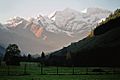
Hohe Tauern National Park

This huge park stretches across three Austrian states: Salzburg, Tyrol, and Carinthia. It was established in stages, starting in 1981. Hohe Tauern covers a large part of the main Alpine mountain range. It's about 100 kilometers long and 40 kilometers wide!
Inside the park, you'll find massive glaciers, valleys shaped by ancient ice, and large areas where rivers have deposited rocks and soil. There are also high Alpine pastures where animals graze, and huge forests filled with larch, spruce, and pine trees. It's a true wilderness adventure!
Nock Mountains National Park

Located in Carinthia, this park was created in 1987. It protects the unique Nock Mountains range, which is part of the Gurktal Alps. The Nock Mountains are known for their rounded, grassy peaks, which look very different from the jagged, rocky peaks of other Alpine areas. It's a beautiful place for hiking and enjoying nature.
Neusiedler See–Seewinkel National Park

This park is in Burgenland and was established in 1993. It covers Lake Neusiedl, which is a very shallow and large lake, along with its shores and surrounding areas. This park is special because it's part of a larger area that is a UNESCO World Heritage Site. It's shared with Hungary and is a very important place for birds and unique plants that live in wetlands.
Danube-Auen National Park

Stretching from the city of Vienna into Lower Austria, this park was founded in 1996. It follows the Danube river, one of Europe's most important rivers, all the way to the border with Slovakia. This national park protects one of the largest untouched floodplains in Central Europe. Floodplains are areas next to rivers that get flooded, creating very rich environments for wildlife. You can even cycle through parts of it on the EuroVelo 6 cycling path!
Kalkalpen National Park
Found in Upper Austria, this park opened in 1997. It covers the Sengsengebirge and Reichraminger Hintergebirge mountain ranges, which are part of the Upper Austrian Prealps. "Kalkalpen" means "Limestone Alps," and this park is famous for its vast forests and hidden cave systems within the limestone mountains. It's a great place to explore untouched nature.
Thayatal National Park

This park is in Lower Austria and was established in 2000. It's centered around a winding part of the Thaya river, right on the border with the Czech Republic. The park connects with a similar national park in the Czech Republic, creating a larger protected area. The steep slopes along the river form beautiful, rocky water gaps, making it one of Austria's most scenic river valleys.
Gesäuse National Park

Located in Styria, this park was created in 2002. It covers the Gesäuse mountain range, which is part of the northeastern Ennstal Alps. The park is famous for the dramatic water gap where the Enns river cuts through the mountains. It's a wild and rugged area, perfect for adventurers who love towering peaks and rushing rivers.
Images for kids
-
Fuscherkarkopf massif, Hohe Tauern
-
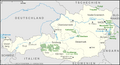
Outline map of Austria's National Parks


