
Navaho Peak facts for kids
Quick facts for kids Navaho Peak |
|
|---|---|

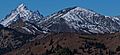
West aspect, from Teanaway Peak
|
|
| Highest point | |
| Elevation | 7,223 ft (2,202 m) |
| Prominence | 1,143 ft (348 m) |
| Isolation | 1.3 mi (2.1 km) |
| Parent peak | Three Brothers (7,303 ft) |
| Geography | |

Navaho Peak
Location in Washington (state)

Navaho Peak
Location in the United States
|
|
| Location | Kittitas County / Chelan County Washington, U.S. |
| Parent range | Wenatchee Mountains Cascade Range |
| Topo map | USGS Enchantment Lakes |
| Climbing | |
| Easiest route | class 2 hiking |
Navaho Peak is a mountain that stands 7,223-foot (2,202-metre) tall. It is located in Washington state, right on the edge of the Alpine Lakes Wilderness. This peak is shared between Kittitas County and Chelan County.
Navaho Peak is the fourth-highest point in the Teanaway area of the Wenatchee Mountains. It sits about two miles northeast of Earl Peak. The land around it is managed by the Wenatchee National Forest. Water from the peak flows into the Teanaway River to the south. It also drains north into Ingalls Creek, which is part of the Wenatchee River system. From the top of Navaho Peak, you can see amazing views of Mount Stuart and the Stuart Range.
Navaho Peak is located east of the Cascade Range. This means the area is a bit drier than places to the west. In summer, it can get warm, and sometimes there are thunderstorms.
Most weather systems come from the Pacific Ocean. They travel east towards the Cascade Mountains. When these weather systems reach the tall Cascade peaks, they are forced to rise. This causes them to drop their moisture as rain or snow on the western side of the mountains. This process is called Orographic lift.
Because of this, the eastern slopes of the Cascades get less rain than the western slopes. In winter, it's often cloudy. But in summer, high pressure systems over the Pacific Ocean usually bring clear skies.
The Alpine Lakes Wilderness has very rugged land. You can see sharp peaks, rocky ridges, and deep valleys carved by glaciers. There are also granite walls and over 700 mountain lakes.
Long ago, major geological events created this varied landscape. These events caused big changes in elevation across the Cascade Range. This also led to the different climates we see today. The land here ranges from about 1,000 feet (300 m) in the lower parts to over 9,000 feet (2,700 m) on Mount Stuart.
The Cascade Range began forming millions of years ago. This happened during the late Eocene Epoch. The North American Plate was moving over the Pacific Plate. This movement caused many volcanic eruptions. Also, small pieces of the Earth's crust, called terranes, helped create the North Cascades about 50 million years ago.
During the Pleistocene period, which was over two million years ago, glaciers played a big role. They moved forward and backward many times. This movement carved and shaped the land. The last glaciers in the Alpine Lakes area started melting about 14,000 years ago. They had moved north of the Canada–US border by 10,000 years ago. The "U"-shaped valleys you see were formed by these glaciers. The rising of the land (called uplift) and cracks in the Earth (called faulting), along with glaciation, have created the tall peaks and deep valleys of the Alpine Lakes Wilderness.
Images for kids
-
Mt. Stuart (left) and Navaho Peak, from southeast
-
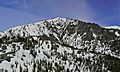
East aspect
-
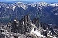
Navaho Peak (left) and Earl Peak (right) from Little Annapurna, Nightmare Needles centered
-
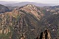
Navaho Peak seen from Little Annapurna


