Neighborhoods in Manchester, New Hampshire facts for kids
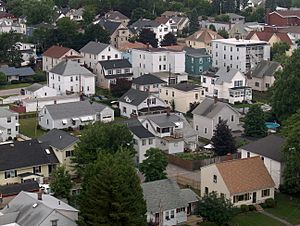
Welcome to Manchester, the biggest city in New Hampshire! Did you know it's divided into 25 different neighborhoods? Each neighborhood has its own special feel. Some even have groups that help make them better places to live. However, these groups don't have official power in the city's government.
Some of the main neighborhoods have been around for a long time. On the West Side, you'll find places like Amoskeag, Rimmon Heights, Notre Dame/McGregorville, and Piscataquog/Granite Square. On the East Side, there's the North End, Janeville/Corey Square, Hallsville, and Bakersville. Plus, Youngsville and Goffes Falls are on the edges of the city.
In 2007, Manchester started a special program called "Neighborhood Initiatives." The goal was to make sure all neighborhoods are lively and great places to live. This is where people spend most of their time, whether they are living, playing, shopping, or going to school. The program helps neighborhoods become more active and grow. It also helps bring back a strong sense of community. The first neighborhood to get these improvements was Rimmon Heights on the West Side. This led to new growth and investments there. The city also planned to expand this program to the Hollow neighborhood in 2012.
Contents
Discover Downtown Manchester
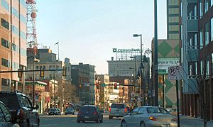
Downtown Manchester is like the city's heart. It's where a lot of history, business, and culture come together. It's also a big center for money matters in New Hampshire. If you're looking for places to eat or fun things to do at night, Downtown is the place to be! It sits right along the east side of the Merrimack River.
Downtown has a few main parts. There's the central area around Elm Street, between Bridge and Granite streets. Then there's the Millyard, which used to be the huge Amoskeag mills. You'll also hear about the "NOB" (North of Bridge) and South Downtown. Inside these bigger areas are smaller spots, like the Gaslight and Warehouse districts. There's also the Cultural District around Victory Park.
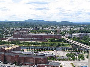
Years ago, in the early 1990s, Downtown had many empty buildings. But it has really bounced back! The old Amoskeag Millyard has been rebuilt, and people now live in its historic buildings. New places like the SNHU Arena and Northeast Delta Dental Stadium have also been built.
Because of all these improvements, more people want to live Downtown. Between 2000 and 2010, the number of residents grew by almost 20%! Many old buildings, once homes for mill workers, are now cool, modern apartments called condominiums. You can also find new shops and colleges that have been cleverly built into older buildings along Commercial Street and Canal Street.
The Millyard is also home to many important company offices. These include Dyn, Deka, Texas Instruments, and Eversource Energy New Hampshire.
Besides shops, restaurants, and homes, Downtown has also seen more colleges and cultural places. The Palace Theatre has been a key part of Hanover Street since it reopened in 1973. The New Hampshire Institute of Art is located near Victory Park. The University of New Hampshire at Manchester moved its campus to the Millyard between 1999 and 2001. In 2002, the Massachusetts College of Pharmacy and Health Sciences opened a campus in the NOB area.
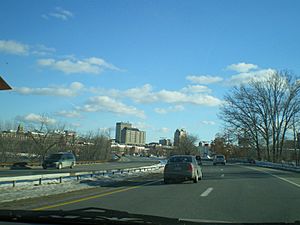
Downtown Manchester also has some of the tallest buildings in northern New England. City Hall Plaza is the tallest building north of Cambridge, Massachusetts. Close behind is the Brady Sullivan Plaza. Both are 20 stories high! Other tall buildings you might see are the Citizens Bank building, Brady-Sullivan Tower, the Carpenter Center, the Wall Street Tower, and Anthem Tower. When you look at them from the west, these tall buildings stand out. Below them, you can see the long, flat Millyard buildings along the Merrimack River.
West Side Neighborhoods
The West Side of Manchester has its own unique neighborhoods. Let's explore some of them.
Mast Road Area
Mast Road is a neighborhood with a mix of homes. It grew up along the old road that led to Goffstown. It also followed a streetcar line that existed before World War II. St. Anselm College and Pinardville are just outside the city limits, near the northern edge of this neighborhood.
Northwest Manchester
Northwest is mostly a suburban area along Front Street. It has some of the biggest undeveloped lands left in the city. This neighborhood includes the old Amoskeag area, where Manchester's very first mills once stood. It's also home to Hackett Hill. Here you'll find the 602-acre Manchester Cedar Swamp Preserve. This preserve has trees that are over 450 years old! Since the early 2000s, Hackett Hill has been the site of a lot of new homes being built.
Notre Dame Neighborhood
Notre Dame is a busy neighborhood with many homes. It's located below Rimmon Heights, along McGregor Street and Notre Dame Avenue. Historically, many French-Canadian families lived here. The Catholic Medical Center and Ste. Marie Church are important landmarks in this area.
Piscataquog Area
Piscataquog is another busy residential neighborhood. It's centered around Granite Square and the Piscataquog River.
Rimmon Heights
Rimmon Heights is a busy neighborhood with many homes. It has historically been home to many French Canadian families. It's centered along Kelley and Amory streets. This neighborhood was the first to be part of the City's Neighborhood Initiatives program, which started in 2007. Since then, the area has seen improvements to its streets and new shops opening up.
Wolfe Park Area
Wolfe Park is mostly a suburban neighborhood. It has more homes closer to the old "A Street" streetcar line and Wolfe Park itself.
East Side Neighborhoods
The East Side of Manchester also has many different neighborhoods, each with its own character.
Bakersville
Bakersville is located just south of Downtown. It's near Baker Brook and Baker Street. This area has seen some new developments recently. This includes the Elliot at River's Edge Urgent Care Center. Bakersville Elementary School is also located here.
Corey Square
Corey Square was once known as Janeville. The streets in this busy city center neighborhood are unique. They are angled and don't follow the usual grid pattern of the city.
Downtown East Side
Eaton Heights
Eaton Heights is mostly a suburban neighborhood. It grew along the old streetcar line that ran along Hanover Street.
Green Acres
Green Acres is mostly a suburban neighborhood that developed after World War II. It is home to Green Acres Elementary School and McLaughlin Middle School.
Hallsville
Hallsville is one of the busiest neighborhoods in the city center. It's centered around the Hollow area, where Massabesic Street breaks away from the city's typical grid. This neighborhood is home to Elliot Hospital, Hallsville Elementary School, and the start of the Rockingham Rail Trail.
Hanover Hill
Hanover Hill is a neighborhood with a medium number of homes, located east of Corey Square. From here, you can get amazing views of Downtown and the Uncanoonuc Mountains to the west. It's also home to Derryfield Park, which is one of Manchester's most famous parks.
Highlands
The Highlands is mostly a suburban neighborhood. It grew along the old streetcar line that went to Pine Island Park.
Kalivas Union
Kalivas Union is one of the busiest neighborhoods in the city center. It includes a large part of Valley and Union streets.
North End
The North End is a neighborhood that has historically been home to wealthy families. It has many homes and businesses along Webster Street. As you go further north, it becomes more suburban. It's home to Stark Park, Webster Elementary School, and The Derryfield School. Southern New Hampshire University is located right on the border between Manchester's North End and the South Hooksett part of Hooksett.
Somerville
Somerville is a neighborhood with a medium number of homes. It's south of Hallsville and centered around Somerville and Wilson streets.
Southside
Southside is mostly a suburban neighborhood that developed after World War II. It's where you'll find many of the city's suburban-style shops and businesses along South Willow Street.
Straw/Smyth
Straw/Smyth is a residential neighborhood that has historically been home to wealthy families. It is home to the Currier Museum of Art.
Beyond the Main Highways
Some Manchester neighborhoods are located a bit further out, beyond the I-93/293 highways.
Wellington
This area is near the Wellington Road Exit 1 on Route 101 West.
Youngsville
Youngsville is located near Candia Road and Lake Massabesic.
Southeast Manchester
This area stretches from Brown Avenue all the way to the border with Litchfield.
Crystal Lake Area
The Crystal Lake area is around Corning Road and the South Mammoth Road area.
Lower South Willow/Airport Area
Lower South Willow is where you'll find the Mall of New Hampshire and many large stores. It's also the location of Manchester-Boston Regional Airport. This area is mostly industrial.
Goffes Falls
Goffes Falls is an older neighborhood centered around Cohas Brook, where the Goffe's Falls are located. Over the last 50 years, a lot of airport development has happened in this area.
 | Tommie Smith |
 | Simone Manuel |
 | Shani Davis |
 | Simone Biles |
 | Alice Coachman |


