Nerstrand, Minnesota facts for kids
Quick facts for kids
Nerstrand
|
|
|---|---|

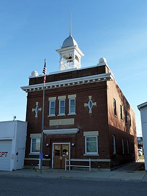
Nerstrand's historic City Hall building, listed on the National Register of Historic Places
|
|

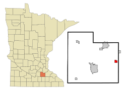
Location of Nerstrand, Minnesota
|
|
| Country | United States |
| State | Minnesota |
| County | Rice |
| Area | |
| • Total | 1.42 sq mi (3.67 km2) |
| • Land | 1.42 sq mi (3.67 km2) |
| • Water | 0.00 sq mi (0.00 km2) |
| Elevation | 1,188 ft (362 m) |
| Population
(2020)
|
|
| • Total | 273 |
| • Density | 192.93/sq mi (74.47/km2) |
| Time zone | UTC-6 (Central (CST)) |
| • Summer (DST) | UTC-5 (CDT) |
| ZIP code |
55053
|
| Area code(s) | 507 |
| FIPS code | 27-45196 |
| GNIS feature ID | 2395175 |
Nerstrand (pronounced NEER-schrand) is a small city in Rice County, Minnesota, in the United States. It's a quiet place with a rich history.
Minnesota State Highway 246 is the main road that goes through Nerstrand. Other important roads like Highway 56 and Highway 60 are also close by.
Contents
History of Nerstrand
Nerstrand began in 1856 when a Norwegian immigrant named Osmund Osmundson moved to the area. He claimed land and built a farm, hoping to create a town there.
In 1877, Osmundson built a store on what would become the main street. Later, in 1885, a railroad was built through the area. Osmundson then officially planned out the town, naming it after his hometown of Nedstrand in Norway.
Nerstrand became a hub for many Norwegian immigrants. Some people from the area, like Osmundson himself, even became state lawmakers. A famous thinker named Thorstein Veblen, who grew up nearby, became a well-known sociologist and economist.
The town officially became a city in 1897. Its first city hall was built that year, and a larger one was built in 1907. The Nerstrand City Hall is now a historic building. The Osmund Osmundson House and the Bonde Farmhouse are also on the National Register of Historic Places. This means they are important historical sites. The Thorstein Veblen Farmstead is even a National Historic Landmark. The old railroad tracks are no longer there.
How Nerstrand is Governed
Nerstrand is run by a city council and a mayor. The city council has four members who help make decisions for the community.
Geography of Nerstrand
Nerstrand covers about 1.42 square miles (3.67 square kilometers) of land. There is no water within the city limits.
In the past, the area was known for "Nerstrand Hill." This hill was very steep and made it hard for trains to travel on the railroad tracks. It was the steepest part of the line from St. Paul to Manly Junction, Iowa.
Nerstrand Elementary School
Nerstrand has its own elementary school for students from kindergarten to fifth grade. It's called Nerstrand Elementary School. The school is part of the Faribault Public Schools district. It operates as a special type of public school called a charter school. In the 2019–2020 school year, about 155 students attended the school.
Places to Visit in Nerstrand
There are a few interesting places to see around Nerstrand:
- Nerstrand-Big Woods State Park: This state park is very close to the city. It's a great place to explore nature.
- Valley Grove Church Building: This old church is considered an important historical site.
- Other churches in the area include:
- St. John's United Church of Christ (about 3 miles southwest)
- Grace Lutheran Church (located right in town)
- Nerstrand United Methodist Church (located right in town)
- Gol Lutheran Church (about 4 miles southeast)
Nerstrand's Economy
For many years, Nerstrand has provided services to local farmers. Today, a large grain elevator still operates in the city. It handles crops from nearby farms and provides many jobs in Nerstrand.
Over time, as cars became more common, people started shopping in bigger towns. Many residents now travel to Northfield or Faribault for their shopping. Northfield has two colleges, and Faribault is the county seat.
Because of this, Nerstrand has become more of a "bedroom community." This means many people who live in Nerstrand work in other towns like Northfield, Faribault, or Kenyon. However, some new businesses have moved into Nerstrand. These include a cabinet shop and two special construction companies. They help fill empty buildings in the city.
Population of Nerstrand
| Historical population | |||
|---|---|---|---|
| Census | Pop. | %± | |
| 1900 | 256 | — | |
| 1910 | 292 | 14.1% | |
| 1920 | 245 | −16.1% | |
| 1930 | 283 | 15.5% | |
| 1940 | 251 | −11.3% | |
| 1950 | 228 | −9.2% | |
| 1960 | 584 | 156.1% | |
| 1970 | 231 | −60.4% | |
| 1980 | 255 | 10.4% | |
| 1990 | 210 | −17.6% | |
| 2000 | 233 | 11.0% | |
| 2010 | 295 | 26.6% | |
| 2020 | 273 | −7.5% | |
| U.S. Decennial Census | |||
The population of Nerstrand changes over time. In 2010, there were 295 people living in the city. There were 108 households, which are groups of people living together. Most of these households (91) were families.
About 40.7% of households had children under 18 living with them. Most households (73.1%) were married couples. The average household had 2.73 people, and the average family had 2.96 people.
The average age of people in Nerstrand in 2010 was 37.1 years old. About 28.1% of residents were under 18. About 15.3% were 65 years old or older. The population was almost evenly split between males (47.8%) and females (52.2%). In 2020, the population was 273 people.
Famous Person from Nerstrand
Thorstein Veblen (1857–1929) was a very important person who grew up near Nerstrand. He is known as an economist and sociologist. His most famous book is The Theory of the Leisure Class.
Veblen's farm, called the Thorstein Veblen Farmstead, had some interesting new ideas for its time. It even had what might have been the first "bucket elevator" on a farm in Rice County. This machine helps move things like grain.
The Thorstein Veblen Farmstead was fixed up in 1994 to become a historic site. Sometimes, it is open for people to visit. As of 2016, it is used as a flower farm.
See also
 In Spanish: Nerstrand (Minnesota) para niños
 | Delilah Pierce |
 | Gordon Parks |
 | Augusta Savage |
 | Charles Ethan Porter |


