
New River, Arizona facts for kids
Quick facts for kids
New River, Arizona
|
|
|---|---|

Welcome sign
|
|

Location in Maricopa County and the state of Arizona
|
|

New River, Arizona
Location in Arizona

New River, Arizona
Location in the United States
|
|
| Country | United States |
| State | Arizona |
| County | Maricopa |
| Area | |
| • Total | 56.12 sq mi (145.35 km2) |
| • Land | 56.11 sq mi (145.32 km2) |
| • Water | 0.01 sq mi (0.03 km2) |
| Elevation | 2,136 ft (651 m) |
| Population
(2020)
|
|
| • Total | 17,290 |
| • Density | 308.16/sq mi (118.98/km2) |
| Time zone | UTC-7 (MST) |
| ZIP codes |
85087 (New River)
85086 (Phoenix) |
| Area code(s) | 623 |
| FIPS code | 04-49360 |
| GNIS feature ID | 2408920 |
New River is a community in Maricopa County, Arizona, United States. It's called a census-designated place (CDP) because it's a community that the government counts for population, but it's not officially a city or town. In 2020, about 17,290 people lived there. This was an increase from 14,952 people in 2010.
Contents
History of New River

New River gets its name from a seasonal wash. A wash is like a riverbed that only has water after it rains a lot. This wash is part of the Agua Fria River system. The Agua Fria River eventually flows into the Salt River.
The community of New River was started in 1868 by a person named Lord Darrell Duppa. He created it as a stop for stagecoaches. Stagecoaches were like old buses pulled by horses. They carried people and mail long distances.
For many years, New River was the end of the paved part of the old Black Canyon Highway. After New River, the road turned into a dirt path that went all the way to the city of Prescott. Today, this old highway is known as Interstate 17.
Geography of New River
New River is located in the northern part of Maricopa County. It has some interesting neighbors! To the north, it's next to the Tonto National Forest. To the east, you'll find Cave Creek. To the south, it borders Phoenix. And to the west, it's next to Phoenix and Anthem. The area known as Desert Hills is also part of New River.
New River is about 36 miles (58 km) north of downtown Phoenix. The area covers about 56.1 square miles (145 km2). Only a tiny bit of this area, about 0.01 square miles (0.026 km2), is water. Two mountains are located within the community: Daisy Mountain, which is 3,176-foot (968 m) tall, and Gavilan Peak, which is 2,980-foot (910 m) tall.
Population Information
| Historical population | |||
|---|---|---|---|
| Census | Pop. | %± | |
| 2000 | 10,740 | — | |
| 2010 | 14,952 | 39.2% | |
| 2020 | 17,290 | 15.6% | |
| U.S. Decennial Census | |||
Every ten years, the United States government counts how many people live in different areas. This is called a census. In 2000, New River had 10,740 people. By 2010, the population grew to 14,952. The most recent count in 2020 showed 17,290 people living in New River. This shows that the community has been growing steadily!
Fun Places to Visit
New River and the surrounding area have many cool places to explore:
- Cave Creek Regional Park
- Lake Pleasant Regional Park
- Wranglers Roost Stagecoach Stop (This place was started way back in 1890!)
- Spur Cross Ranch
- Daisy Mountain Preserve
- New River Kiwanis Park
- Gavilan Peak – This mountain got its name in the 1880s. That's when the U.S. Cavalry and the Apaches had a battle nearby. "Gavilan" means "sparrow hawk" in Spanish and "hawk" in Apache.
Old Buildings in New River
There are still some old and historic buildings left in New River. These buildings help us remember the past.
- Historic structures of New River, Arizona
-
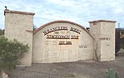
Front gate of the historic Wranglers Roost Stagecoach Stop
-
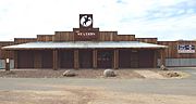
The Station
-
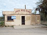
The Jack Ass Acres Service Station, which has since been demolished and replaced by a nearby Shell station


See also
 In Spanish: New River (Arizona) para niños
