
New River (Broward County, Florida) facts for kids
Quick facts for kids New River |
|
|---|---|
.jpg)
The New River as seen from Fort Lauderdale's Riverwalk
|
|
| Lua error in Module:Location_map at line 420: attempt to index field 'wikibase' (a nil value). | |
| Country | United States |
| State | Florida |
| County | Broward County |
| Physical characteristics | |
| Main source | 26°06′39″N 80°06′44″W / 26.1109199°N 80.1122665°W |
The New River is a special kind of river called a tidal estuary in South Florida, United States. This means its water mixes fresh water from land with salty water from the ocean. The river connects to the famous Everglades wetlands through many man-made canals.
After flowing through the city of Fort Lauderdale, the New River joins the Intracoastal Waterway. This waterway is like a highway for boats along the coast. Finally, the river reaches the Atlantic Ocean at a place called Port Everglades. The entire New River is located within Broward County. It is formed where three main canals meet. These canals start in the Everglades and branch off from the Miami Canal.
- The North New River Canal flows south from Lake Okeechobee. Then it turns east along the north side of State Road 84.
- The South New River Canal flows east from the Miami Canal. It runs along the north side of Griffin Road.
- Another canal flows east along the south side of Sunrise Boulevard.
Contents
Why is it Called the New River?
There are two interesting stories about how the New River got its name.
The Seminole Legend
A legend from the Seminole people says the river appeared suddenly one night. There were strong winds, loud noises, and the ground shook. Because it seemed so new, the Seminoles supposedly called it Himmarshee. This word means "new water." Some writers in the 1940s thought this might have been caused by an earthquake. The earthquake could have made the roof of an underground river collapse.
However, some historians say the Seminole name for the river was actually Coontie-Hatchee. This name came from the Zamia integrifolia plant, called coontie, which grew along the riverbanks. During a time when Florida was booming in the 1920s, some people tried to change the river's name to Himmarshee-Hatchee.
The Explorer's Maps
The English name "New River" comes from early maps made by explorers. The mouth of the river, where it met the Atlantic Ocean, often changed its location. This happened because the sand on the barrier island kept shifting.
Each time the coast was surveyed and mapped, the river's entry point would be in a different spot. So, the new location wouldn't be on older maps. From the ocean, it would look like a brand new river had just appeared. Because of this, mapmakers would simply write "new river" next to the spot. The first settlers then learned the river by this name, and it stuck.
History of the River Area
Long ago, before Europeans arrived, people of the Glades culture lived along the New River. Later, the Tequesta people lived there. By the mid-1700s, the Tequesta people were gone.
In 1788, a family from the Bahamas, Charles and Frankee Lewis, started the first settlement along the river. But they had to leave when the Second Seminole War began. The U.S. Army then built forts called Fort Lauderdale near the river.
Fort Lauderdale's Beginnings
The first fort was built where the North and South Forks of the river met. Later, the fort moved to different spots. In the 1890s, a man named Frank Stranahan opened a trading post at a ferry crossing on the New River. This trading post became the very beginning of the city of Fort Lauderdale.
Frank's wife, Ivy Stranahan, remembered how clear the New River was in those early days. She said you could easily see fish and even large sharks in its deep waters.
River Changes Over Time
Before the 1900s, the New River had two natural streams: the North Fork and the South Fork. These streams joined and flowed directly into the Atlantic Ocean. But the river was changed a lot in the early 20th century.
- The North Fork was extended and became the C-12 Canal. This canal runs along where Sunrise Boulevard is today.
- The South Fork was extended by two canals. One of these was the C-11, or South New River Canal, which connects to the Miami Canal.
- The South New River Canal also connects to the Dania Cutoff Canal. This canal leads east to the Intracoastal Waterway.
North New River Canal
The most important change to the New River was the creation of the North New River Canal. This canal is also known as the G-15 canal.
Building the Canal
Work on dredging this canal began in 1906. This was soon after Napoleon B. Broward became the governor of Florida. He had promised to drain parts of the Everglades. The canal was dug about 42 miles south from Lake Okeechobee. Then it turned east for about 16 miles to where the river used to end near Fort Lauderdale.
The canal was finished in 1912. This happened after Lock No. 1, North New River Canal was built. This lock is in the city of Plantation, Florida, just west of Fort Lauderdale.
Canal's Importance
The North New River Canal was a very important way to travel and transport goods. It connected the coast to the inner parts of Florida, south of Lake Okeechobee. Steamships and other boats used the canal. They brought lumber, farm tools, and people to towns like Okeelanta and South Bay.
The boats then carried crops from these farms back to the coast. From there, the goods were sent north by train. However, the canal started to get clogged with silt (shoaling). Also, new roads and train lines were built. Because of this, Lock No. 1 was closed to boat traffic in 1926.
Today, the North New River Canal is a major part of South Florida's water control system. The South Florida Water Management District manages it. Lock No. 1 was added to the U.S. National Register of Historic Places in 1978. This means it's an important historical site.
Images for kids
-
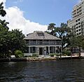
Stranahan House, the oldest building in Fort Lauderdale, originally built as a trading post
-
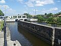
Lock No. 1 on the North New River Canal, with modern water control structure in background


