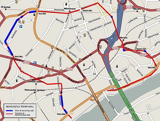
Newcastle town wall facts for kids
Quick facts for kids Newcastle town wall |
|
|---|---|
| Newcastle upon Tyne, England | |
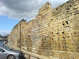
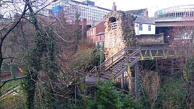
The Newcastle town wall at Orchard Street, running south towards the River Tyne
|
|
| Coordinates | 54°58′18″N 1°37′17″W / 54.97167°N 1.62139°W |
| Height | Up to 7.6 metres (25 ft) high. |
| Site history | |
| Built | 13th and 14th century |
| Materials | Stone |
The Newcastle town wall is a very old defensive wall built in the Middle Ages (around the 13th and 14th centuries). It's located in Newcastle upon Tyne, northern England. This amazing wall was built to protect the town from attacks and invasions, especially during times of war.
The wall was about 3 kilometers (2 miles) long. It was also at least 2 meters (6.5 feet) thick and could be as tall as 7.6 meters (25 feet)! It had six main gates, like big entrances, and seventeen towers. There were also smaller towers called turrets and secret postern gates.
For a long time, the town wall was kept in good shape, especially when there was a risk of attack from Scottish armies. It helped Newcastle successfully defend itself at least twice! But as the wars between England and Scotland became less common, the wall wasn't looked after as well.
During the English Civil War, Scottish soldiers managed to break through the wall using special digging tools and artillery (cannons). By the mid-1700s, the wall was no longer needed for defense. As Newcastle grew and changed, large parts of the wall were taken down. Today, the biggest remaining sections are called the West Walls, found on the western side of the city.
Contents
Building the Great Wall
The Newcastle town wall was built in the 1200s and 1300s. Its main purpose was to stop Scottish invaders. Newcastle is about 97 kilometers (60 miles) from the River Tweed, which was the border between England and Scotland back then.
At that time, England and Scotland were often fighting. This led to wars like the Wars of Scottish Independence. Scottish kings often tried to invade the North of England when England seemed weak. For example, David I of Scotland invaded Northumberland three times between 1136 and 1138. Even though Newcastle had a strong castle, it wasn't enough to protect the homes and businesses of the local merchants. So, everyone agreed that a strong town wall was needed.
Paying for the Wall
To pay for the wall, a special tax called "murage" was collected. Murus is a Latin word meaning "wall." This tax was first collected in 1265, so building probably started soon after. People paid this tax for over a hundred years, which means the wall likely wasn't finished until the mid-1300s.
Changing the Plans
The original plan for the wall changed a bit during construction. At first, the castle was supposed to be part of the wall, acting as a strong point. However, the castle was on high ground near the river. If the wall followed this path, it would leave out the area by the river where many important merchants lived. Their homes would be unprotected.
So, the route was changed. The wall turned south at the Neville Tower and went down to the river instead. A similar change happened on the east side of the city. In 1299, the village of Pandon officially became part of Newcastle. The wall then made a sharp turn east to go around Pandon until it reached the river.
From Pandon, the wall ran west along the river, separating the town from the busy docks. This part of the wall had several "water gates." These gates allowed ships to be loaded and unloaded. In 1616, an order was given to close these gates at night. This was to stop servants from throwing rubbish into the river. A few gates were left open for sailors to return to their ships, but they were watched all night.
Wall's Features
When it was finished, the wall was about 3 kilometers (2 miles) long. It was at least 2 meters (6.5 feet) thick and up to 7.6 meters (25 feet) high. It had six main gateways and seventeen towers. There were also smaller turrets and postern gates.
The towers stuck out from the walls. They were close enough that archers in one tower could shoot at attackers trying to climb the wall near another tower. This meant attackers faced arrows from the front (from the wall) and from both sides (from the towers).
The postern gates were smaller, private entrances. They were used by places like the Dominican Order of Blackfriars (a monastery) and the Hospital of St Mary the Virgin (a charity that still exists). These gates allowed them to reach their property outside the walls.
Even before the walls were fully built, an outer ditch was added. It was known as the King's Dyke. This ditch was over 11 meters (36 feet) wide and 4.5 meters (15 feet) deep in front of the Herber and Morden Towers. It was completed by 1317.
Later Years of the Wall
The town wall was kept in good condition as long as there was a threat from the Scots. In 1342, David II of Scotland invaded Northumberland and tried to attack Newcastle, but he failed. In 1388, another Scottish army attacked the town but was pushed back.
As the wars between England and Scotland became less common, especially after the two countries joined under one king in 1603, the wall was not maintained as well.
In 1640, during the Bishops' Wars, and again in 1644, during the English Civil War, Scottish armies were able to invade Newcastle despite the wall. In 1648, the Parliamentarian governor had the wall repaired. More repairs happened in 1667.
During the Jacobite rebellions of 1715 and 1745, the wall was made much stronger. This was in case a Jacobite army attacked, but no attacks happened then.
After this, the wall slowly started to disappear. Parts were torn down little by little to make way for new buildings and to create better access to the town center. The last repairs to the wall were made in the early 1800s, during the Napoleonic Wars. After that, people believed the town no longer needed a defensive wall.
The first part of the wall to be taken down was the section along the quayside (the area by the river where ships docked). People thought it was "a very great obstacle to carriages and a hindrance to the despatch of business." This section was pulled down in 1763, and the Sand Gate followed in 1798.
Main Gates of the Wall
There were six main gateways through the wall. Here they are, listed clockwise from the western end:
- Close Gate – This gate was at the end of Close, a street that ran west from Sandhill, next to the river. In early times, Close was where many rich traders lived. Their houses had their own docks on the river. It's thought that the wall only went a short distance east from Close Gate along the river. North of Close Gate was the Whitefriars Tower. It was near this part of the wall that Scottish forces, led by General Leven, broke through in 1644. They used mines and cannons to breach the wall. Close Gate was torn down in 1797.
- West Gate – This gate led to the West Road, which followed the path of an old Roman Wall. It had big oak gates and iron doors. An old writer named John Leland called it "a mightye strong thinge." At one point, it was used as a prison. Later, it became the meeting hall for carpenters. Seventeen prisoners were held there during the Civil War, but they managed to escape. It was demolished in 1811.
- New Gate – This gate had very strong defenses. From 1399, it was used as the town's gaol (prison). Prisoners who were sentenced to death would be taken from here along Gallowgate to the gallows on the Town Moor. East and west sections were added in 1702 and 1706. A north gate was added later. By 1820, the prison was in bad shape and not secure. A new prison was built, and New Gate began to be torn down in June 1823. The newer parts were removed first, but the oldest part of the structure remained for a while. Despite some people wanting to keep it, it was removed that September. New Gate is believed to have replaced an older gate called Berwick Gate.
- Pilgrim Gate or Pilgrim Street Gate – This gate, at the north end of Pilgrim Street, led out towards Jesmond. Pilgrims (people on a religious journey) would use this gate to travel to St Mary's Chapel. The chapel's ruins can still be seen overlooking what is now Jesmond Dene. A room above the gate was used by the Joiners' Company. It was demolished in 1802.
- Pandon Gate – This gate led northeast from the village of Pandon. It had folding iron gates but no portcullis (a heavy, gridded gate that slides down). Until 1648, it was used as a hall for the Barber Chirurgeons (a group of barbers and surgeons). It was demolished in 1795.
- Sand Gate – This gate led to the riverbank on the east side of the town. It was demolished in 1798.
Until 1695, all the gates were closed at night.
Preserving History: What's Left Today
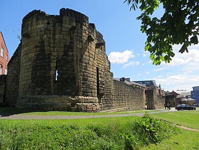
Most of the wall was torn down in the 1700s and 1800s. But the biggest parts that are left are on the western side of the city. The longest continuous section runs along Back Stowell Street, in the Chinatown area. This part includes three towers: Herber Tower, Morden Tower, and Ever Tower. Since 1964, Morden Tower has been used for poetry readings!
At the north end of this section, St Andrew's Street cuts through the wall. You can see small pieces of the wall in St Andrew's churchyard, across the street. At the south end, Stowell Street cuts through to Bath Lane. The old outer ditch has been rebuilt along this part of the wall.
From Stowell Street, a complete section of wall, which includes Durham Tower, stretches southeast along Bath Lane. It ends near Westgate Road. The walls between Westgate Road and St Andrew's Street are known as the West Walls.
Near the river, you can see a partially demolished section of the wall on the steep bank between Hanover Street and Close. This part was covered by warehouses for many years. Another large piece of the wall stands north of Hanover Street, next to Orchard Street. You can also see the dug-up foundations of Gunner Tower in Pink Lane.
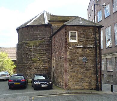
On the eastern side of the city, three towers still stand: Plummer Tower in Croft Street, Corner Tower at the corner of City Road and Melbourne Street, and Sallyport Tower in Tower Street. Plummer Tower was changed by the Company of Cutlers in the 1600s. The Company of Masons added an upper floor and a new front in the 1700s. Sallyport Tower was changed in 1716 with a banqueting hall (a big dining room) on the first floor, which was used by the Shipwrights' Company.
The remaining parts of the walls are protected as a Scheduled Ancient Monument. This means they are important historical sites that are legally protected.
 | Selma Burke |
 | Pauline Powell Burns |
 | Frederick J. Brown |
 | Robert Blackburn |


