
Newfields, New Hampshire facts for kids
Quick facts for kids
Newfields, New Hampshire
|
|
|---|---|

Swamscott Street
|
|

Location in Rockingham County and the state of New Hampshire.
|
|
| Country | United States |
| State | New Hampshire |
| County | Rockingham |
| Incorporated | 1849 |
| Villages |
|
| Area | |
| • Total | 7.3 sq mi (18.8 km2) |
| • Land | 7.1 sq mi (18.4 km2) |
| • Water | 0.2 sq mi (0.4 km2) 2.31% |
| Elevation | 75 ft (23 m) |
| Population
(2020)
|
|
| • Total | 1,769 |
| • Density | 249/sq mi (96.3/km2) |
| Time zone | UTC-5 (Eastern) |
| • Summer (DST) | UTC-4 (Eastern) |
| ZIP code |
03856
|
| Area code(s) | 603 |
| FIPS code | 33-51380 |
| GNIS feature ID | 0873678 |
Newfields is a town in Rockingham County, New Hampshire, United States. It is a part of New England. In 2020, the town had 1,769 people living there. The main village, also called Newfields, had 378 residents in 2020. It is located along New Hampshire Route 85 and the Squamscott River. This village is known for its charming old houses.
Newfields is one of New Hampshire's wealthier towns. This means that many families living there have a higher income.
Contents
History of Newfields

Newfields became an official town in 1849. Before that, it was part of Exeter until 1727. Then, it became part of Newmarket. People first settled here in 1638. It was called "Newfield Village" as early as 1681. Later, it was known as "South Newmarket." This was like a smaller part or parish of Newmarket.
The name "Newfields" wasn't used in official population counts until 1900. Before that, it was listed as "South New Market" or "South Newmarket." Sometimes, it was just called "Newmarket."
Early Settlers and Protection
In the early days, people built special "garrison" houses. These were strong homes designed to protect against attacks from Native American groups. Some of the first important officials, called "tithingmen," in the village included Jonathan Robinson (1678) and Abraham Folsom (1720).
A New Bridge and Its Impact
In 1775, a bridge was built over the Squamscott River. This bridge connected Newfields with Stratham. It made the trip to Exeter shorter. Exeter had become the capital during the American Revolutionary War. However, this new road went around the old town center. This helped to keep the historic part of Newfields just as it was.
Wesleyan Academy
A school called Wesleyan Academy opened here in 1817. It was a Methodist school that taught both boys and girls. This was quite advanced for the time. The school had money problems because there weren't many Methodists nearby who could support it. So, in 1825, the academy moved to Wilbraham, Massachusetts. Today, the Newfields Elementary School stands on the old academy's site. About 170 children attend this school, from kindergarten to fifth grade.
Modern Connections and Renaming
In 1841, the Boston and Maine Railroad started offering train service to the community. This helped the town grow. Later, in 1880, a doctor named John M. Brodhead gave his library and $10,000 to the town. He had one condition: the town had to be renamed "Newfields." The town officially became "Newfields" in 1895.
Gallery
-
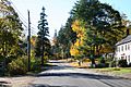
Main Street
-
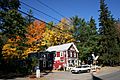
Newfields Country Store
-
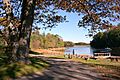
Town landing


Geography of Newfields
Newfields covers a total area of about 18.8 square kilometers (7.3 square miles). Most of this area, about 18.4 square kilometers (7.1 square miles), is land. The rest, about 0.4 square kilometers (0.15 square miles), is water. Water makes up about 2.31% of the town's total area.
The Piscassic River flows through the western part of the town. This river eventually flows into the Lamprey River. The eastern side of Newfields is bordered by the Squamscott River. All the water in the town flows into the Great Bay and Piscataqua River system. The highest point in Newfields is Oakland Hill. It is about 240 feet (73 meters) above sea level.
Roads in Newfields
Several important roads pass through Newfields. These include New Hampshire Route 85, New Hampshire Route 87, and New Hampshire Route 108.
Neighboring Towns
Newfields shares its borders with several other towns:
Population Information
In 2010, Newfields had 1,680 people living there. There were 575 households, and 487 of these were families. Most of the people living in Newfields were white (97.5%). A small number were African American, Native American, or Asian. About 1.3% of the population was Hispanic or Latino.
Age and Households
About 44.5% of households had children under 18 living with them. Most households (76.3%) were married couples living together. The average household had 2.92 people, and the average family had 3.19 people.
About 28.6% of the population was under 18 years old. About 9.1% of the population was 65 years or older. The average age in Newfields was 43.1 years.
Notable People from Newfields
Many interesting people have connections to Newfields:
- William Badger (1752–1830), a skilled shipbuilder.
- John Brodhead (1770–1838), who served as a U.S. congressman.
- Maggie Hassan (born 1958), a U.S. senator.
- Winthrop Hilton (1671–1710), an officer in the colonial military.
- James Pike (1818–1895), who also served as a U.S. congressman.
- Anita Shreve (1946–2018), a well-known novelist.
- Chris Sununu (born 1974), the current governor of New Hampshire.
See also
 In Spanish: Newfields para niños
